


View Information About HSR Ratings

This enormous bridge is one of the longest historic cantilever truss spans surviving in the United States today, with a main span of 1,200 feet. At the time of completion, this was the longest cantilever truss span in the United States. The bridge is also a rare and highly significant example of a fixed (non-movable) bridge designed by famous engineer Joseph Strauss, whose main claim to fame was the design of bascule bridges. Note that Strauss was listed as the chief engineer for the Golden Gate Bridge, but he in fact did very little of the design work. Perhaps Strauss played a larger role in the design of this bridge, however. This bridge is highly significant due to its span length, but it also is noted for its unusual design details, including member sizing that differs from that found on other cantilever truss bridges. For example the diagonal members adjacent to the main vertical posts are heavier in design than the main post itself. The overall shape of the cantilever truss is somewhat unusual as well. Careful observers will also find the bridge's numerous unused holes that were used as temporary pin connections for assisting in the construction and erection of the bridge.
This bridge continues to carry heavy traffic with numerous trucks as well in an industrial setting. Despite this the bridge retains excellent historic integrity with no major alterations. The physical condition of the bridge also appears to be very good. Hopefully this will continue to be the case given the significance of the bridge.
Joseph Strauss proposed a bridge of similar design for Port Huron, Michigan and Sarnia, Ontario, but it was rejected, likely in part due to an unusual approach configuration.
The steel stringer approaches and bents at the north end of the bridge were reconstructed ca. 1950. The new bents still retain a traditional riveted design with lacing and so despite not being original they still math the design and appearance of the bridge. However, the pin and hanger details of the steel stringers are a typical 1950s construction practice.

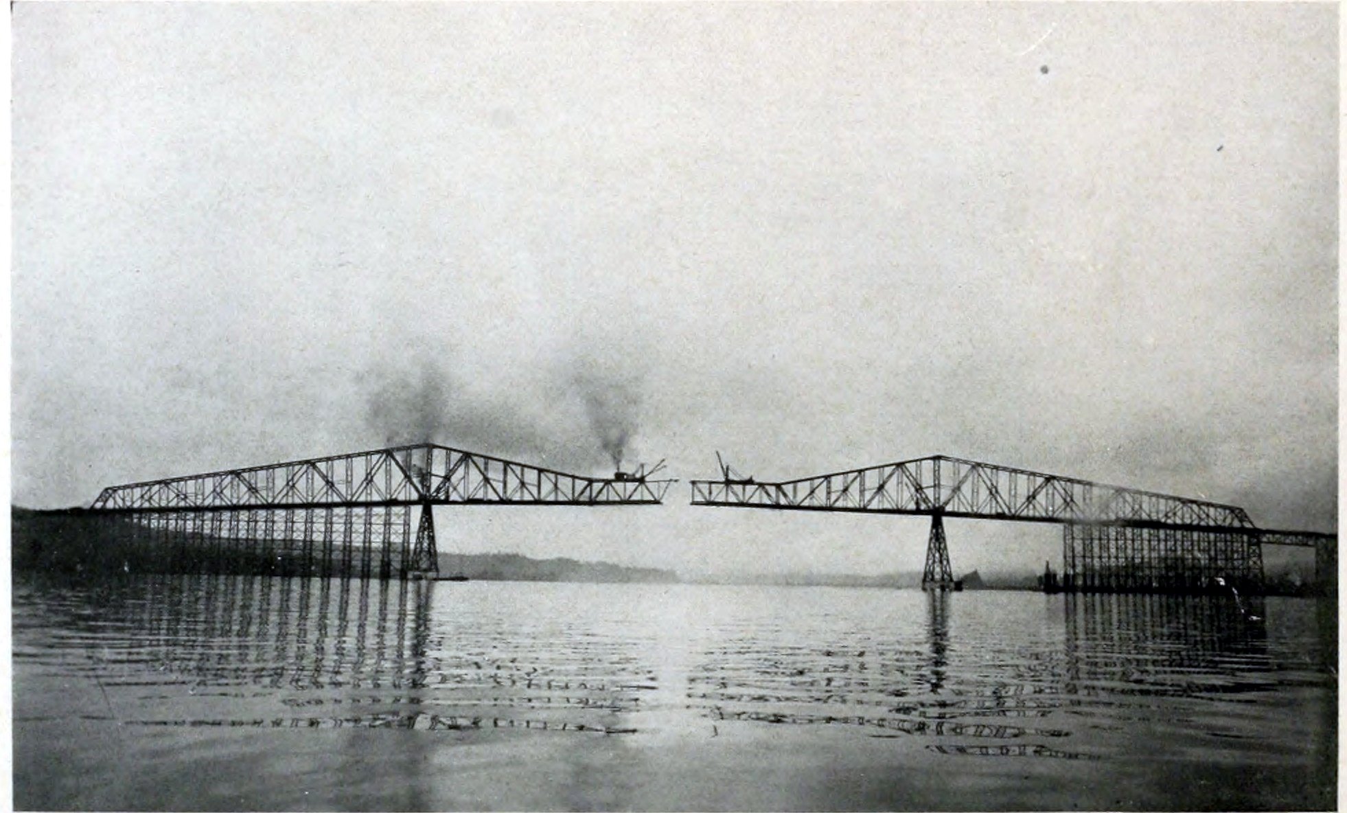
Above: Historical photo showing bridge construction. Erection of the suspended span is in progress here.

Above: Historical mid-20th century photo of bridge.

Above: Historical photo of bridge.
![]()

![]()

![]()
![]()
![]()
Coordinates (Latitude, Longitude):
Search For Additional Bridge Listings:
Bridgehunter.com: View listed bridges within 0.5 miles (0.8 kilometers) of this bridge.
Bridgehunter.com: View listed bridges within 10 miles (16 kilometers) of this bridge.
Additional Maps:
Google Streetview (If Available)
GeoHack (Additional Links and Coordinates)
Apple Maps (Via DuckDuckGo Search)
Apple Maps (Apple devices only)
Android: Open Location In Your Map or GPS App
Flickr Gallery (Find Nearby Photos)
Wikimedia Commons (Find Nearby Photos)
Directions Via Sygic For Android
Directions Via Sygic For iOS and Android Dolphin Browser
USGS National Map (United States Only)
Historical USGS Topo Maps (United States Only)
Historic Aerials (United States Only)
CalTopo Maps (United States Only)

© Copyright 2003-2024, HistoricBridges.org. All Rights Reserved. Disclaimer: HistoricBridges.org is a volunteer group of private citizens. HistoricBridges.org is NOT a government agency, does not represent or work with any governmental agencies, nor is it in any way associated with any government agency or any non-profit organization. While we strive for accuracy in our factual content, HistoricBridges.org offers no guarantee of accuracy. Information is provided "as is" without warranty of any kind, either expressed or implied. Information could include technical inaccuracies or errors of omission. Opinions and commentary are the opinions of the respective HistoricBridges.org member who made them and do not necessarily represent the views of anyone else, including any outside photographers whose images may appear on the page in which the commentary appears. HistoricBridges.org does not bear any responsibility for any consequences resulting from the use of this or any other HistoricBridges.org information. Owners and users of bridges have the responsibility of correctly following all applicable laws, rules, and regulations, regardless of any HistoricBridges.org information.
![]()