HistoricBridges.org Menu: HistoricBridges.org Menu:


We Recommend:
Bach Steel - Experts at historic truss bridge restoration.

HistoricBridges.org: Bridge Browser

Chicago Bridge

Chicago Bridge

Primary Photographer(s): C. Hanchey, CC BY-NC 2.0, flickr.com/photos/21953562@N07/

Bridge Documented: May 17, 2015

View Photos
and Videos
View Maps
and Links

Facility Carried / Feature Intersected
AB-547 Over Bow River
Location
Rural: Wheatland County, Alberta: Canada
Structure Type
Metal 10 Panel Rivet-Connected Parker Through Truss, Fixed and Approach Spans: Metal Bailey Pony Truss, Fixed
Construction Date and Builder / Engineer
1949 By Builder/Contractor: Dominion Bridge Company of Montréal, Québec (Dominion Bridge Company of Winnipeg, Manitoba)
Rehabilitation Date
Not Available or Not Applicable
Main Span Length
175.0 Feet (53.3 Meters)
Structure Length
670.0 Feet (204.2 Meters)
Roadway Width
Not Available
Spans
3 Main Span(s) and 1 Approach Span(s)
Inventory Number
Not Applicable

Historic Significance Rating (HSR)
View Information About HSR Ratings

Bridge Documentation

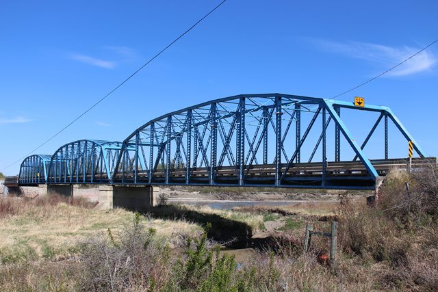
This is a historic 1908 Parker through truss bridge on Hwy 547 over the Bow River on the Siksika Reservation in Wheatland County, Alberta, Canada. Flooding in June 2013 washed out the north embankment. The bridge was repaired and reopened in November 2014. A Bailey truss span was added at this end.


Divider

Photo Galleries and Videos: Chicago Bridge


View Photo Gallery

Bridge Photo-Documentation

Original / Full Size Photos
A collection of overview and detail photos. This gallery offers photos in the highest available resolution and file size in a touch-friendly popup viewer.
Alternatively, Browse Without Using Viewer

Divider

View Photo Gallery

Bridge Photo-Documentation

Mobile Optimized Photos
A collection of overview and detail photos. This gallery features data-friendly, fast-loading photos in a touch-friendly popup viewer.
Alternatively, Browse Without Using Viewer

Divider

Maps and Links: Chicago Bridge

Coordinates (Latitude, Longitude):

Search For Additional Bridge Listings:

HistoricBridges.org Bridge Browser: View listed bridges within 0.5 miles (0.8 kilometers) of this bridge.

HistoricBridges.org Bridge Browser: View listed bridges within 10 miles (16 kilometers) of this bridge.

Additional Maps:

Google Maps

Google Streetview (If Available)

Bing Maps

OpenStreetMap

GeoHack (Additional Links and Coordinates)

Apple Maps (Via DuckDuckGo Search)

Apple Maps (Apple devices only)

MapQuest

HERE We Go Maps

ACME Mapper

Waze Map

Android: Open Location In Your Map or GPS App

Flickr Gallery (Find Nearby Photos)

Wikimedia Commons (Find Nearby Photos)

Directions Via Sygic For Android

Directions Via Sygic For iOS and Android Dolphin Browser


Divider
 
Home Top

Divider

About - Contact

© Copyright 2003-2024, HistoricBridges.org. All Rights Reserved. Disclaimer: HistoricBridges.org is a volunteer group of private citizens. HistoricBridges.org is NOT a government agency, does not represent or work with any governmental agencies, nor is it in any way associated with any government agency or any non-profit organization. While we strive for accuracy in our factual content, HistoricBridges.org offers no guarantee of accuracy. Information is provided "as is" without warranty of any kind, either expressed or implied. Information could include technical inaccuracies or errors of omission. Opinions and commentary are the opinions of the respective HistoricBridges.org member who made them and do not necessarily represent the views of anyone else, including any outside photographers whose images may appear on the page in which the commentary appears. HistoricBridges.org does not bear any responsibility for any consequences resulting from the use of this or any other HistoricBridges.org information. Owners and users of bridges have the responsibility of correctly following all applicable laws, rules, and regulations, regardless of any HistoricBridges.org information.

Admin Login

Divider