

View Information About HSR Ratings
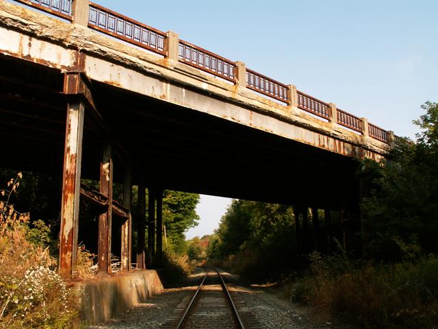
This was an attractive steel stringer bridge noted for intact, original decorative railings that were a standard of the period, and also for a heavy skew. During a visit to this bridge in 2005, it had recently been posted for an unusually low weight limit for obvious reasons: its heavy steel deterioration. The next visit, it had been closed to traffic. According to Allegan County Road Commission, the bridge was closed September 29, 2005. An article, available for downloading above details the steps that Allegan County Road Commission took to seal this bridge's doom. Although this bridge could be described as semi-historic, the structure, certainly had historic value as a remnant of 10th Street's trunk line past, prior to the US-131 expressway. It also was important as an attractive structure that added to the interest of the roadway. It utilized a standard railing design for the period that featured an attractive, ornamental design. Such beauty will not be present on this bridge's replacement.
This bridge was not properly maintained over the years, accounting for its extremely poor condition prior to demolition. The steel bent supports for this bridge had rusted so bad that they were nearly gone in many places. In short, salt damage was likely the main cause, leaking through the joints in the bridge onto the supports below. The bridge's steel stringers had suffered as well. If the amount of salt had been limited on this bridge, and the beams were maintained through a regular painting program, this disaster could have been prevented. By not maintaining the bridge, the result was the loss of an attractive bridge, and also local businesses lost money during the time that the bridge was closed and being replaced. Taxpayer money was also wasted, since proper maintenance generally is less costly than total replacement. Federal and state funding programs are largely to blame for encouraging local county road commissions to not properly maintain bridges, and instead seek replacements after letting the bridges fall apart. The result is a significant waste of taxpayer dollars. These are programs that legislators should seek to revise to more effectively manage this nation's highway transportation system.
This bridge is tagged with the following special condition(s): Unorganized Photos
![]()
![]()
![]()
![]()
This historic bridge has been demolished. This map is shown for reference purposes only.
Coordinates (Latitude, Longitude):
Search For Additional Bridge Listings:
Bridgehunter.com: View listed bridges within 0.5 miles (0.8 kilometers) of this bridge.
Bridgehunter.com: View listed bridges within 10 miles (16 kilometers) of this bridge.
Additional Maps:
Google Streetview (If Available)
GeoHack (Additional Links and Coordinates)
Apple Maps (Via DuckDuckGo Search)
Apple Maps (Apple devices only)
Android: Open Location In Your Map or GPS App
Flickr Gallery (Find Nearby Photos)
Wikimedia Commons (Find Nearby Photos)
Directions Via Sygic For Android
Directions Via Sygic For iOS and Android Dolphin Browser
USGS National Map (United States Only)
Historical USGS Topo Maps (United States Only)
Historic Aerials (United States Only)
CalTopo Maps (United States Only)

© Copyright 2003-2024, HistoricBridges.org. All Rights Reserved. Disclaimer: HistoricBridges.org is a volunteer group of private citizens. HistoricBridges.org is NOT a government agency, does not represent or work with any governmental agencies, nor is it in any way associated with any government agency or any non-profit organization. While we strive for accuracy in our factual content, HistoricBridges.org offers no guarantee of accuracy. Information is provided "as is" without warranty of any kind, either expressed or implied. Information could include technical inaccuracies or errors of omission. Opinions and commentary are the opinions of the respective HistoricBridges.org member who made them and do not necessarily represent the views of anyone else, including any outside photographers whose images may appear on the page in which the commentary appears. HistoricBridges.org does not bear any responsibility for any consequences resulting from the use of this or any other HistoricBridges.org information. Owners and users of bridges have the responsibility of correctly following all applicable laws, rules, and regulations, regardless of any HistoricBridges.org information.
![]()