

View Information About HSR Ratings
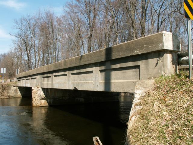
This is the longest of only two straight chord concrete through girders remaining in Calhoun County. The bridge is two spans, and is thus historically significant as one of very few remaining multi-span concrete girders in Michigan. The bridge was built in 1920. The contractor was A. R. Morrison from Port Huron, Michigan. It was built as a State Reward Bridge, and the plaque on the bridge lists it as number 23, making it an early example of a bridge built under the State Reward program. This girder is the type in which inset rectangles appear only on the outside of the girders. The bridge is in good overall condition, although some spalling is starting to show.
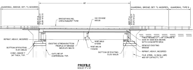
Although Calhoun County is home to the nationally recognized first of its kind Historic Bridge Park, and Calhoun County has also been kind enough to store numerous historic bridges from other counties that would otherwise have been demolished, Calhoun County's actual commitment to preserving its own on-system bridges is somewhat lacking. Of the several remaining historic bridges, none have been rehabilitated recently (and all are in need), and this beautiful historic bridge was demolished and replaced. The replacement bridge is an ugly set of pre-stressed concrete box beams with the appearance of little more than a slab of concrete. It will look like nearly every bridge structure built in the past 20+ years. The replacement bridge as drawn in the bid package is shown below. A photo of the replacement bridge is also shown below.

![]()
![]()
This historic bridge has been demolished. This map is shown for reference purposes only.
Coordinates (Latitude, Longitude):
Search For Additional Bridge Listings:
Bridgehunter.com: View listed bridges within 0.5 miles (0.8 kilometers) of this bridge.
Bridgehunter.com: View listed bridges within 10 miles (16 kilometers) of this bridge.
Additional Maps:
Google Streetview (If Available)
GeoHack (Additional Links and Coordinates)
Apple Maps (Via DuckDuckGo Search)
Apple Maps (Apple devices only)
Android: Open Location In Your Map or GPS App
Flickr Gallery (Find Nearby Photos)
Wikimedia Commons (Find Nearby Photos)
Directions Via Sygic For Android
Directions Via Sygic For iOS and Android Dolphin Browser
USGS National Map (United States Only)
Historical USGS Topo Maps (United States Only)
Historic Aerials (United States Only)
CalTopo Maps (United States Only)

© Copyright 2003-2024, HistoricBridges.org. All Rights Reserved. Disclaimer: HistoricBridges.org is a volunteer group of private citizens. HistoricBridges.org is NOT a government agency, does not represent or work with any governmental agencies, nor is it in any way associated with any government agency or any non-profit organization. While we strive for accuracy in our factual content, HistoricBridges.org offers no guarantee of accuracy. Information is provided "as is" without warranty of any kind, either expressed or implied. Information could include technical inaccuracies or errors of omission. Opinions and commentary are the opinions of the respective HistoricBridges.org member who made them and do not necessarily represent the views of anyone else, including any outside photographers whose images may appear on the page in which the commentary appears. HistoricBridges.org does not bear any responsibility for any consequences resulting from the use of this or any other HistoricBridges.org information. Owners and users of bridges have the responsibility of correctly following all applicable laws, rules, and regulations, regardless of any HistoricBridges.org information.
![]()