

View Information About HSR Ratings

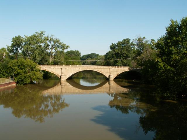
This bridge is a three span concrete arch bridge, with earth fill. The bridge has had its original guardrails removed, which greatly detracts from the aesthetic qualities of the structure. In fact, most people probably don't know that this bridge is so old it was only the 256th bridge ever built as a trunkline bridge. The original plaque, set into the new guardrails remains to tell the fact. The plaque also mentions Rapid Railway Co, so this bridge must have once carried some sort of railroad tracks across its deck as well when it was built. MDOT's site lists this bridge as the sixth largest surviving earth filled concrete arch bridge in the state, at a length of 241 feet. MDOT lists the construction date as 1920, although the plaque lists a date of 1919. The bridge does not have a weight limit and continues to carry heavy traffic, testifying to the strength of the structure.

A photo from the 1922 Biennial Report of the Michigan State Highway Department featured a photo of the bridge with its original railings.
According to Michigan Department of Transportation, the Gratiot Avenue Bridge is a bridge for which repair and/or rehabilitation is impossible due to a problem with the design of the bridge which includes spread footings in the substructure. MDOT provided the following explanation:
The construction of the bridge simply does not allow piles to be installed to combat scour without compromising the structural integrity of the bridge. Drilling the cores for the piles would go through rebar. And the spread footing of course cannot be excavated without again compromising the pier completely. So scour at the piers cannot be addressed without completely rebuilding the bridge, thus destroying the historic integrity. The construction of the bridge itself coupled with the spread footings is a bad combination in this instance.

Therefore, MDOT has no alternative buy to replace it with a mundane modern bridge with no heritage value whatsoever. How should MDOT respond in a situation where the preservation of a historic bridge is found to be impossible? In the view of HistoricBridges.org, MDOT should commit to the preservation of another of Michigan's concrete arch bridges for which preservation is possible. The Fulton Street Bridge in Grand Rapids appears to be the best candidate (whose preservation would include replication of the bridge's original railings), although the BL-196 Bridge would also be acceptable.
As part of Section 106 mitigation, MDOT has committed to produce interpretive signage to describe the historic bridge and its heritage.
During a public involvement stage of the planning process, the public commented that they wanted the replacement bridge to have an arch shape to it. To fulfill those requests, MDOT will attach a fake arch-shaped facade to the outside of the replacement bridge which is little more than an ugly pre-stressed slab of concrete. If the general public wanted the replacement bridge to have an arch-like appearance and some aesthetic value to it, than that is fine. However, to compare the replacement bridge to the historic bridge in any way is extremely misleading, and to claim the that replacement bridge has any relationship to the design or heritage value of the historic bridge is untrue. MDOT was quoted in a newspaper saying "Even though it will be a new bridge it will keep the same architectural integrity and aesthetics of the bridge it will replace..." This statement is essentially untrue. The architecture of the Gratiot Avenue Bridge was uniform with the physical bridge superstructure, because the architecture of the bridge... that of a series of arches... was also the functioning superstructure. Since the entire superstructure has been removed, all of the architectural integrity has been lost. Retaining the architectural integrity as part of a replacement project would have required leaving the original spandrel walls in place, while removing the earthen fill and placing the replacement bridge beams in between the spandrel walls. This would be similar to what was done with the open spandrel Pearl Street Bridge in Grand Rapids, although because of the spread footings problem, this would not have worked on the Gratiot Avenue Bridge. Further, the original aesthetics of the historic Gratiot Avenue Bridge will be completely lost. The shape of the arch facades are different on the replacement bridge. Further, the stone stamps placed on the concrete of the replacement attempt to replicate a stone arch not a concrete arch, and in reality they don't even replicate a stone arch very well. Finally, the railings placed on the replacement bridge do not replicate the original railings on the bridge. Thus, both the architectural integrity and aesthetic integrity have been lost in the replacement. Because the historic bridge has been determined impossible to rehabilitate, there is really nothing else to be done in this regard. However that doesn't mean that misleading statements should be made about the replacement bridge. It is unclear what MDOT meant with this statement.

![]()

![]()
![]()
![]()
This historic bridge has been demolished. This map is shown for reference purposes only.
Coordinates (Latitude, Longitude):
Search For Additional Bridge Listings:
Bridgehunter.com: View listed bridges within 0.5 miles (0.8 kilometers) of this bridge.
Bridgehunter.com: View listed bridges within 10 miles (16 kilometers) of this bridge.
Additional Maps:
Google Streetview (If Available)
GeoHack (Additional Links and Coordinates)
Apple Maps (Via DuckDuckGo Search)
Apple Maps (Apple devices only)
Android: Open Location In Your Map or GPS App
Flickr Gallery (Find Nearby Photos)
Wikimedia Commons (Find Nearby Photos)
Directions Via Sygic For Android
Directions Via Sygic For iOS and Android Dolphin Browser
USGS National Map (United States Only)
Historical USGS Topo Maps (United States Only)
Historic Aerials (United States Only)
CalTopo Maps (United States Only)

© Copyright 2003-2024, HistoricBridges.org. All Rights Reserved. Disclaimer: HistoricBridges.org is a volunteer group of private citizens. HistoricBridges.org is NOT a government agency, does not represent or work with any governmental agencies, nor is it in any way associated with any government agency or any non-profit organization. While we strive for accuracy in our factual content, HistoricBridges.org offers no guarantee of accuracy. Information is provided "as is" without warranty of any kind, either expressed or implied. Information could include technical inaccuracies or errors of omission. Opinions and commentary are the opinions of the respective HistoricBridges.org member who made them and do not necessarily represent the views of anyone else, including any outside photographers whose images may appear on the page in which the commentary appears. HistoricBridges.org does not bear any responsibility for any consequences resulting from the use of this or any other HistoricBridges.org information. Owners and users of bridges have the responsibility of correctly following all applicable laws, rules, and regulations, regardless of any HistoricBridges.org information.
![]()