
View Information About HSR Ratings
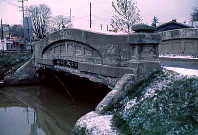
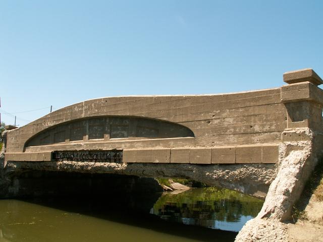
Built in 1922, this is one of Michigan's oldest remaining curved-chord though girder bridges, and despite numerous signs forbidding it, is a popular fishing spot. The curved-chord through girder bridges are unique to the state of Michigan. They were a standard plan, however each one is a bit different. This one does not have decorative openings in the girders, which is a characteristic of the smaller curved-chord through girders, like Yale Road Bridge. The end posts on this bridge are a bit more decorative than most of this bridge type. This example was built in 1922, when Vernier Street was part of M-29. M-29 was realigned in 1932 just south of this bridge. The existing modern bridge there sits on the concrete abutments of this 1932 structure. The 1932 plaque remains on the current 1973 M-29 Bridge.
This bridge is in relatively poor condition compared to other examples of this structure type in Michigan. Concrete reinforcement steel can be seen hanging from the bottom of the bridge, which suggests that the bottom of the bridge is falling apart. Part of the outside of the bridge has fallen away as well, which is quite visible. This appears due to a design feature in the older examples of this structure type where the bottom section was assembled using u-shaped blocks of concrete, something that does not appear on the later examples.
The St Clair County Road Commission posted on their website on July 12, 2005 that the previous weight limit of 18-36-40 will be lowered to 10 tons for all vehicles because of "advancing concrete deck deterioration." This is an extremely low weight limit for this bridge type, which suggests that the deterioration is more than just an aesthetic blemish. However, lowering weight limits has also been noted as a path to demolishing a bridge. If a local agency can make the bridge look in bad condition, the chances for receiving money for demolition and replacement is greater. It represents a fundamental flaw in the way transportation money is awarded to local agencies. It essentially rewards local government for not maintaining a bridge.
As of 2012, the bridge is now closed to all traffic, testimony to how utterly complete the failure to maintain this bridge has been.
Despite the relatively poor condition of this bridge, preservation is still something that this bridge deserves, because it is one of the oldest examples of this unique structure type.
Information and Findings From Michigan Historic Bridge InventoryNarrative Description By 1914, an older bridge crossing Swan Creek at Fairhaven was deemed unsafe to carry heavy loads, and the community approached the St. Clair County Road Commission about a new structure. The board of the commission, which had been established only a year earlier, instructed the county highway engineer to prepare a preliminary survey at the site, and calculate the cost of building a new bridge. By October 1915, a total of $8,000 was apparently appropriated by the county or state for the project, but work was delayed. Later, the Grand Trunk Railroad refused to haul road materials, forcing the bridge project to be abandoned in November 1916. The project was revived by the state highway department during its 1921-1922 biennium, when it constructed two trunkline bridges over Swan Creek in Ira Township. Both were 50-foot concrete girder spans with 22-foot roadways. Rose Construction from nearby Marine City built one for $9,959.20. The other, which now carries Vernier Street, was erected by contractor J. E. Mason of Michigan City for $11,894.42. The state paid for the total cost of both structures. Rose Construction was finished with their project by the end of the fiscal year on 1 July 1922. A small amount of the J. E. Mason contract was outstanding at that time, indicating that the Vernier Street Bridge was built in that year. At some later date, the state highway was diverted to run closer to the shoreline to the south. Statement of Significance The Vernier Street Bridge is one of the earliest existing examples of the curved top-chord through-girder bridge, a unique design developed and promoted by the Michigan State Highway Department. As such, it is eligible for the National Register.
|
This bridge is tagged with the following special condition(s): Unorganized Photos
![]()
![]()
![]()
![]()
This historic bridge has been demolished. This map is shown for reference purposes only.
Coordinates (Latitude, Longitude):
Search For Additional Bridge Listings:
Bridgehunter.com: View listed bridges within 0.5 miles (0.8 kilometers) of this bridge.
Bridgehunter.com: View listed bridges within 10 miles (16 kilometers) of this bridge.
Additional Maps:
Google Streetview (If Available)
GeoHack (Additional Links and Coordinates)
Apple Maps (Via DuckDuckGo Search)
Apple Maps (Apple devices only)
Android: Open Location In Your Map or GPS App
Flickr Gallery (Find Nearby Photos)
Wikimedia Commons (Find Nearby Photos)
Directions Via Sygic For Android
Directions Via Sygic For iOS and Android Dolphin Browser
USGS National Map (United States Only)
Historical USGS Topo Maps (United States Only)
Historic Aerials (United States Only)
CalTopo Maps (United States Only)

© Copyright 2003-2024, HistoricBridges.org. All Rights Reserved. Disclaimer: HistoricBridges.org is a volunteer group of private citizens. HistoricBridges.org is NOT a government agency, does not represent or work with any governmental agencies, nor is it in any way associated with any government agency or any non-profit organization. While we strive for accuracy in our factual content, HistoricBridges.org offers no guarantee of accuracy. Information is provided "as is" without warranty of any kind, either expressed or implied. Information could include technical inaccuracies or errors of omission. Opinions and commentary are the opinions of the respective HistoricBridges.org member who made them and do not necessarily represent the views of anyone else, including any outside photographers whose images may appear on the page in which the commentary appears. HistoricBridges.org does not bear any responsibility for any consequences resulting from the use of this or any other HistoricBridges.org information. Owners and users of bridges have the responsibility of correctly following all applicable laws, rules, and regulations, regardless of any HistoricBridges.org information.
![]()