

View Information About HSR Ratings
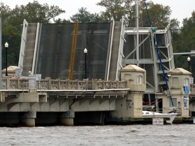
This is a very small bascule span that is in some ways dwarfed by the bridge's very long approach system. This bridge has very little elevation which means this bridge has to be raised for smaller craft than bascule bridges that are positioned higher off the water. The bridge was designed with aesthetics in mind. The four bridge tender houses on this bridge are two more than would generally be needed to operate a bascule bridge in the 1920s (today only one house needs to be staffed). The presence of four houses was likely more of an aesthetic decision rather than a necessity. The approach spans have unusual ornamental concrete railings that are the distinctive design of T. B. Carrick, a local engineer of note. Other bridges designed by T. B. Carrick had this same railing design. The bascule span has its own unusual steel railing. The bascule railing appears to not be original as the use of bolts and welds instead of rivets suggest, but it may be a general replication of the original design.
![]()
![]()
![]()

![]()
![]()
Coordinates (Latitude, Longitude):
Search For Additional Bridge Listings:
Bridgehunter.com: View listed bridges within 0.5 miles (0.8 kilometers) of this bridge.
Bridgehunter.com: View listed bridges within 10 miles (16 kilometers) of this bridge.
Additional Maps:
Google Streetview (If Available)
GeoHack (Additional Links and Coordinates)
Apple Maps (Via DuckDuckGo Search)
Apple Maps (Apple devices only)
Android: Open Location In Your Map or GPS App
Flickr Gallery (Find Nearby Photos)
Wikimedia Commons (Find Nearby Photos)
Directions Via Sygic For Android
Directions Via Sygic For iOS and Android Dolphin Browser
USGS National Map (United States Only)
Historical USGS Topo Maps (United States Only)
Historic Aerials (United States Only)
CalTopo Maps (United States Only)

© Copyright 2003-2024, HistoricBridges.org. All Rights Reserved. Disclaimer: HistoricBridges.org is a volunteer group of private citizens. HistoricBridges.org is NOT a government agency, does not represent or work with any governmental agencies, nor is it in any way associated with any government agency or any non-profit organization. While we strive for accuracy in our factual content, HistoricBridges.org offers no guarantee of accuracy. Information is provided "as is" without warranty of any kind, either expressed or implied. Information could include technical inaccuracies or errors of omission. Opinions and commentary are the opinions of the respective HistoricBridges.org member who made them and do not necessarily represent the views of anyone else, including any outside photographers whose images may appear on the page in which the commentary appears. HistoricBridges.org does not bear any responsibility for any consequences resulting from the use of this or any other HistoricBridges.org information. Owners and users of bridges have the responsibility of correctly following all applicable laws, rules, and regulations, regardless of any HistoricBridges.org information.
![]()