

View Information About HSR Ratings
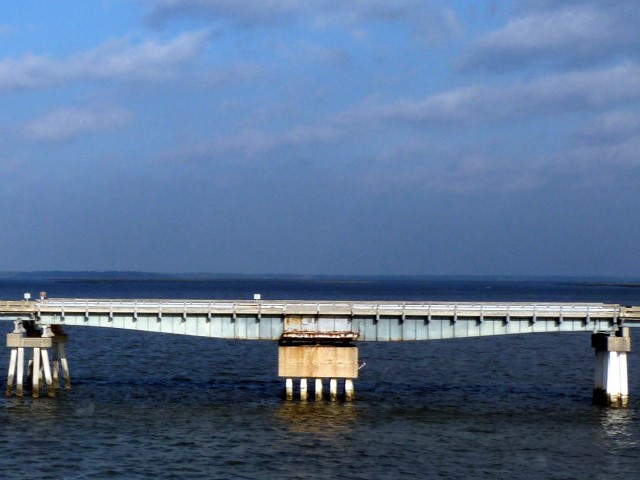
This bridge includes a variable depth riveted deck plate girder swing span that no longer operates for boats. The movable span is dwarfed by the extremely long series of approach spans on either side of the swing span.
Many of Florida's historic movable bridges have been replaced over the years with new fixed bridges on different alignment. Typically, the historic bridges are demolished after the replacement bridge is complete, although sometimes a few fixed approach spans might be left in place as a fishing pier. This riveted deck plate girder swing bridge is a rare example of a movable bridge in Florida that was replaced by a new bridge, but not demolished. The entire bridge was turned into a fishing pier and walkway for non-motorized traffic. While this bridge is not the oldest or rarest of Florida's historic bridges, it is still very nice to see it left standing, where it can be both a historic structure and a function piece of infrastructure for non-motorized traffic.
Presumably one of the reasons why this bridge was left standing next to its replacement is because the waterway no longer is required to accommodate tall boats, meaning that the historic bridge swing span could be left in place without a requirement to operate for boats. The current highway bridge is fixed, yet not much higher, indicating this fact.
![]()
![]()
![]()
Coordinates (Latitude, Longitude):
Search For Additional Bridge Listings:
Bridgehunter.com: View listed bridges within 0.5 miles (0.8 kilometers) of this bridge.
Bridgehunter.com: View listed bridges within 10 miles (16 kilometers) of this bridge.
Additional Maps:
Google Streetview (If Available)
GeoHack (Additional Links and Coordinates)
Apple Maps (Via DuckDuckGo Search)
Apple Maps (Apple devices only)
Android: Open Location In Your Map or GPS App
Flickr Gallery (Find Nearby Photos)
Wikimedia Commons (Find Nearby Photos)
Directions Via Sygic For Android
Directions Via Sygic For iOS and Android Dolphin Browser
USGS National Map (United States Only)
Historical USGS Topo Maps (United States Only)
Historic Aerials (United States Only)
CalTopo Maps (United States Only)

© Copyright 2003-2024, HistoricBridges.org. All Rights Reserved. Disclaimer: HistoricBridges.org is a volunteer group of private citizens. HistoricBridges.org is NOT a government agency, does not represent or work with any governmental agencies, nor is it in any way associated with any government agency or any non-profit organization. While we strive for accuracy in our factual content, HistoricBridges.org offers no guarantee of accuracy. Information is provided "as is" without warranty of any kind, either expressed or implied. Information could include technical inaccuracies or errors of omission. Opinions and commentary are the opinions of the respective HistoricBridges.org member who made them and do not necessarily represent the views of anyone else, including any outside photographers whose images may appear on the page in which the commentary appears. HistoricBridges.org does not bear any responsibility for any consequences resulting from the use of this or any other HistoricBridges.org information. Owners and users of bridges have the responsibility of correctly following all applicable laws, rules, and regulations, regardless of any HistoricBridges.org information.
![]()