

View Information About HSR Ratings
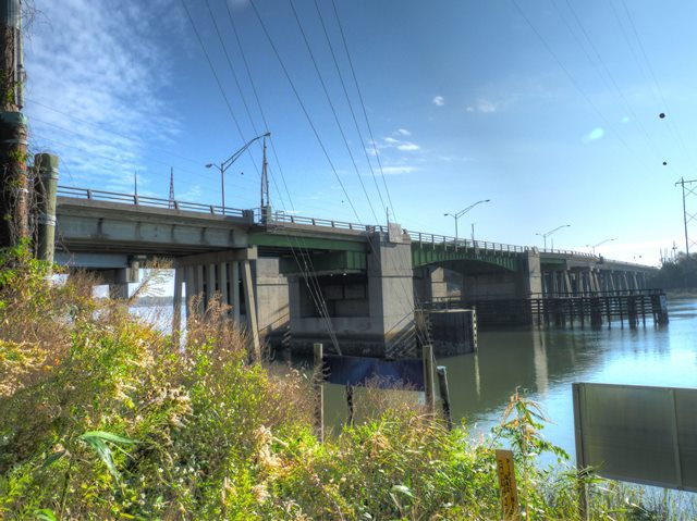
This is a pair of bascule bridges, one carrying eastbound traffic, the other carrying westbound traffic. This pair of bascule bridges are similar in appearance, but not identical, and one has older girders which were moved and reused here.
The history of these bridges is confusing when looking at the National Bridge Inventory, which lists a 1963 construction date for one bridge and a 1989 construction date for the other. However, both bascules are riveted, and rivets were not used in 1989. Their girder design is essentially identical.
Ray Williams contacted HistoricBridges.org and provided the following information.
The southbound span was built in 1963 and was a toll span a long time. From the early 1970s, city and county officials talked of expanding/replacing the 2 lane bridge and highway. By the mid 1980s, monies were awarded for the replacement of the U.S. Hwy 80 bridge over Wilmington River in Thunderbolt, Georgia. The approaches at Causton Bluff were built and to help expedite the opening of the new bridges/highway, and to ease the burden on taxpayers, parts of the old U.S.Hwy 80 drawbridge was used to complete the new span. This explans the rivets on the 1989 construction.
Both of these spans are currently being replaced with a fixed high level span that will not impede marine or motor traffic. First span set to open this year, and the other set to open in 2024.
![]()
![]()
![]()
Coordinates (Latitude, Longitude):
Search For Additional Bridge Listings:
Bridgehunter.com: View listed bridges within 0.5 miles (0.8 kilometers) of this bridge.
Bridgehunter.com: View listed bridges within 10 miles (16 kilometers) of this bridge.
Additional Maps:
Google Streetview (If Available)
GeoHack (Additional Links and Coordinates)
Apple Maps (Via DuckDuckGo Search)
Apple Maps (Apple devices only)
Android: Open Location In Your Map or GPS App
Flickr Gallery (Find Nearby Photos)
Wikimedia Commons (Find Nearby Photos)
Directions Via Sygic For Android
Directions Via Sygic For iOS and Android Dolphin Browser
USGS National Map (United States Only)
Historical USGS Topo Maps (United States Only)
Historic Aerials (United States Only)
CalTopo Maps (United States Only)

© Copyright 2003-2024, HistoricBridges.org. All Rights Reserved. Disclaimer: HistoricBridges.org is a volunteer group of private citizens. HistoricBridges.org is NOT a government agency, does not represent or work with any governmental agencies, nor is it in any way associated with any government agency or any non-profit organization. While we strive for accuracy in our factual content, HistoricBridges.org offers no guarantee of accuracy. Information is provided "as is" without warranty of any kind, either expressed or implied. Information could include technical inaccuracies or errors of omission. Opinions and commentary are the opinions of the respective HistoricBridges.org member who made them and do not necessarily represent the views of anyone else, including any outside photographers whose images may appear on the page in which the commentary appears. HistoricBridges.org does not bear any responsibility for any consequences resulting from the use of this or any other HistoricBridges.org information. Owners and users of bridges have the responsibility of correctly following all applicable laws, rules, and regulations, regardless of any HistoricBridges.org information.
![]()