

View Information About HSR Ratings
This bridge was intended to be built in 1939, but was delayed until 1948 due to World War II. The bridge was turned into a one-way couplet when a companion modern cantilever truss was built next to it in 1982. The bridge today carries eastbound traffic as a result.
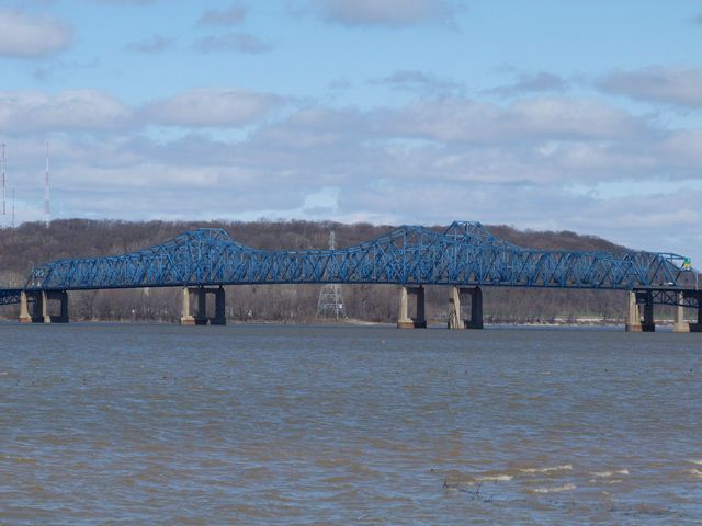
This is one of those bridges that looks exactly like a cantilever truss, with a variable depth truss forming "towers" over the piers, however it appears to lack hinges which means that it functions as a continuous truss, not a cantilever truss. As such, it does not have a suspended span. The same appears to be true for the deck truss approach spans.
This bridge is noted for its use not only of the through truss spans, but also for the unusual, and attractive continuous deck truss approach spans that look nice and compliment the appearance of the through truss. Sadly, in more recent years these approach spans appear to have been widened with deep metal stringers, and this has substantially obstructed the view of the deck trusses, and has harmed the visual beauty of the bridge as a result.
HistoricBridges.org has not fully photo-documented this bridge. Currently only a small number of overview photos are available.
![]()
![]()
![]()
Coordinates (Latitude, Longitude):
Search For Additional Bridge Listings:
Bridgehunter.com: View listed bridges within 0.5 miles (0.8 kilometers) of this bridge.
Bridgehunter.com: View listed bridges within 10 miles (16 kilometers) of this bridge.
Additional Maps:
Google Streetview (If Available)
GeoHack (Additional Links and Coordinates)
Apple Maps (Via DuckDuckGo Search)
Apple Maps (Apple devices only)
Android: Open Location In Your Map or GPS App
Flickr Gallery (Find Nearby Photos)
Wikimedia Commons (Find Nearby Photos)
Directions Via Sygic For Android
Directions Via Sygic For iOS and Android Dolphin Browser
USGS National Map (United States Only)
Historical USGS Topo Maps (United States Only)
Historic Aerials (United States Only)
CalTopo Maps (United States Only)

© Copyright 2003-2024, HistoricBridges.org. All Rights Reserved. Disclaimer: HistoricBridges.org is a volunteer group of private citizens. HistoricBridges.org is NOT a government agency, does not represent or work with any governmental agencies, nor is it in any way associated with any government agency or any non-profit organization. While we strive for accuracy in our factual content, HistoricBridges.org offers no guarantee of accuracy. Information is provided "as is" without warranty of any kind, either expressed or implied. Information could include technical inaccuracies or errors of omission. Opinions and commentary are the opinions of the respective HistoricBridges.org member who made them and do not necessarily represent the views of anyone else, including any outside photographers whose images may appear on the page in which the commentary appears. HistoricBridges.org does not bear any responsibility for any consequences resulting from the use of this or any other HistoricBridges.org information. Owners and users of bridges have the responsibility of correctly following all applicable laws, rules, and regulations, regardless of any HistoricBridges.org information.
![]()