

View Information About HSR Ratings
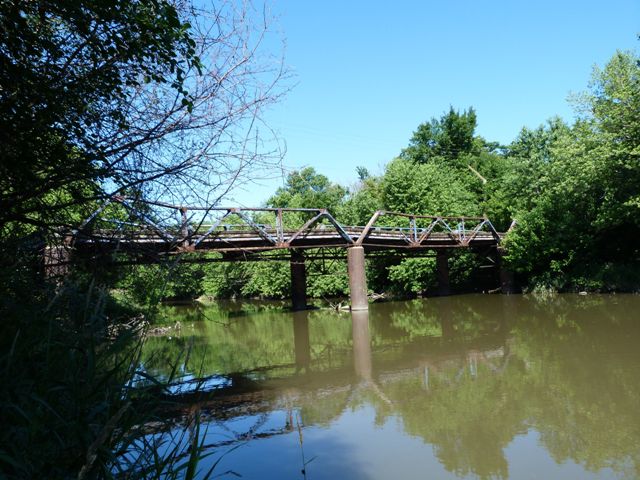
This bridge is a rare example of a multi-span pony truss. It was a four span truss, but the southernmost span has collapsed. The remaining spans are in horrible condition. Widespread complete section loss is present on many truss members, and the top chord is severely bent and buckled. Worse, it appears that scrap metal thieves are responsible for cutting and removing some of the truss members, something that should have caused the bridge to collapsed based on the basic engineering principal of a "fracture critical truss bridge". Truss bridges have been pushed into rivers by floodwaters and been dragged out in better condition than this bridge whose three surviving spans are still standing. This is most unfortunate since among Cook County's extremely large and diverse collection of metal truss bridges, there is no other bridge that is even remotely similar to this bridge. The bridge is for the most part beyond repair (a concession that HistoricBridges.org rarely makes), although it might be possible to salvage some parts to either combine and make a working single span, or to use as a guide to create a replica of the bridge.
Its lightweight construction is strikingly dissimilar from most of Cook County's massive truss bridges designed for heavy traffic. In contrast, this bridge appears to have been designed for lightweight traffic and is more like historic truss bridges found in rural locations. Among lightweight truss bridges, the bridge still is somewhat unusual, in particular the use of a large and simple rolled channel for the top chord and end post. It is unusual to see a single rolled beam for these parts of the truss, especially considering that the smaller truss verticals and diagonals are built-up with lattice and v-lacing. Normally the larger truss beams are built-up and the smaller truss beams are rolled. Indeed, there may be a reason why there are not other bridges with this design, since the buckled top chord may be indicative of the weakness of a single channel top chord.
Despite the condition of this bridge, enough of the bridge remained for HistoricBridges.org to make a comprehensive photo-documentation of the bridge that accurately shows the design and construction of the bridge.
In February 2012, the Blue Island Active Transportation Plan was published and it suggests the bridge "could be restored as a fishing area and bicycle/pedestrian crossing to currently closed Jackson Street." HistoricBridges.org suggests a nice solution to put this bridge into service would be finding, relocating, and reusing the many historic truss spans in Illinois being replaced and use them to deal with missing spans on this bridge and spans beyond repair.
Paul Petraitis contacted HistoricBridges.org and provided the below information about the bridge.
A very weird and weary bridge was open to traffic (scary) as late as the 1970s. It is built over I&M Calumet Feeder Canal Dam constructed in 1848/49. Remains of the dam can be seen in the stone foundation of this bridge on the south side of the river, west side of the bridge road. Nearby is "the pipe" a rather inelegant 12 inch drain that was dropped into the old Calumet Feeder bed and covered over with dirt whenm the dam was blown up. This gets interesting...the I&M Canal engineers needed more water in their canal so it could run "later in the season" so they went back to surveys by Chief Engineer Bucklin from the early 1830's (when the I&M canal was first proposed) and decided to divert all the water from the Little Calumet River "above" Blue Island, via canal to add to the I&M Canal. As soon as the built the dam (a local miller named Rohl built a mill) the Little Calumet backed up into the towns upstream (South Holland Illinois) and over the line into Indiana a ways (the headwaters 40 miles east were of course unaffected) The spring of 1849 was the wettest since 1805 (when the Calumet Rivers switched mouths. that's another story) and the newspapers are full of accounts of the spring thaw as it moved its way north taking out bridges from Peoria to Chicago. The new dam and the spring thaw enraged farmers in a couple counties. When legislation did not work un-named farmers from Illinois and Indiana marched to the dam in the middle of the night and blew it up. No one was prosecuted, no repairs were made, the canal was now higher than the river so became a local drainage feature running in reverse from hoiw it was designed to work initially. The Rohl house, which probably served as an I&M canal house is still there only a few hundred feet from the Alwurn Bridge/dam site. Interesting hydrography here near the Little Calumet River!
Below is a historical postcard of the bridge in all its glory.

Source: blisl, http://www.flickr.com/photos/21178482@N00/5407820755/, CC BY 2.0
![]()


Chicago and Cook County are home to one of the largest collections of historic bridges in the country, and no other city in the world has more movable bridges. HistoricBridges.org is proud to offer the most extensive coverage of historic Chicago bridges on the Internet.
General Chicago / Cook County Bridge Resources
Chicago's Bridges - By Nathan Holth, author of HistoricBridges.org, this book provides a discussion of the history of Chicago's movable bridges, and includes a virtual tour discussing all movable bridges remaining in Chicago today. Despite this broad coverage, the book is presented in a compact format that is easy to take with you and carry around for reference on a visit to Chicago. The book includes dozens of full color photos. Only $9.95 U.S! ($11.95 Canadian). Order Now Direct From The Publisher! or order on Amazon.
Chicago River Bridges - By Patrick T. McBriarty, this is a great companion to Holth's book shown above. This much larger book offers an extremely in-depth exploration of Chicago's movable highway bridges, including many crossings that have not existed for many years. Order Now Direct From The Publisher! or order on Amazon.
View Historic American Engineering Record (HAER) Overview of Chicago Bascule Bridges (HAER Data Pages, PDF)
Chicago Loop Bridges - Chicago Loop Bridges is another website on the Internet that is a great companion to the HistoricBridges.org coverage of the 18 movable bridges within the Chicago Loop. This website includes additional information such as connections to popular culture, overview discussions and essays about Chicago's movable bridges, additional videos, and current news and events relating to the bridges.
Additional Online Articles and Resources - This page is a large gathering of interesting articles and resources that HistoricBridges.org has uncovered during research, but which were not specific to a particular bridge listing.
![]()
![]()
![]()
Coordinates (Latitude, Longitude):
Search For Additional Bridge Listings:
Bridgehunter.com: View listed bridges within 0.5 miles (0.8 kilometers) of this bridge.
Bridgehunter.com: View listed bridges within 10 miles (16 kilometers) of this bridge.
Additional Maps:
Google Streetview (If Available)
GeoHack (Additional Links and Coordinates)
Apple Maps (Via DuckDuckGo Search)
Apple Maps (Apple devices only)
Android: Open Location In Your Map or GPS App
Flickr Gallery (Find Nearby Photos)
Wikimedia Commons (Find Nearby Photos)
Directions Via Sygic For Android
Directions Via Sygic For iOS and Android Dolphin Browser
USGS National Map (United States Only)
Historical USGS Topo Maps (United States Only)
Historic Aerials (United States Only)
CalTopo Maps (United States Only)

© Copyright 2003-2024, HistoricBridges.org. All Rights Reserved. Disclaimer: HistoricBridges.org is a volunteer group of private citizens. HistoricBridges.org is NOT a government agency, does not represent or work with any governmental agencies, nor is it in any way associated with any government agency or any non-profit organization. While we strive for accuracy in our factual content, HistoricBridges.org offers no guarantee of accuracy. Information is provided "as is" without warranty of any kind, either expressed or implied. Information could include technical inaccuracies or errors of omission. Opinions and commentary are the opinions of the respective HistoricBridges.org member who made them and do not necessarily represent the views of anyone else, including any outside photographers whose images may appear on the page in which the commentary appears. HistoricBridges.org does not bear any responsibility for any consequences resulting from the use of this or any other HistoricBridges.org information. Owners and users of bridges have the responsibility of correctly following all applicable laws, rules, and regulations, regardless of any HistoricBridges.org information.
![]()