

View Information About HSR Ratings
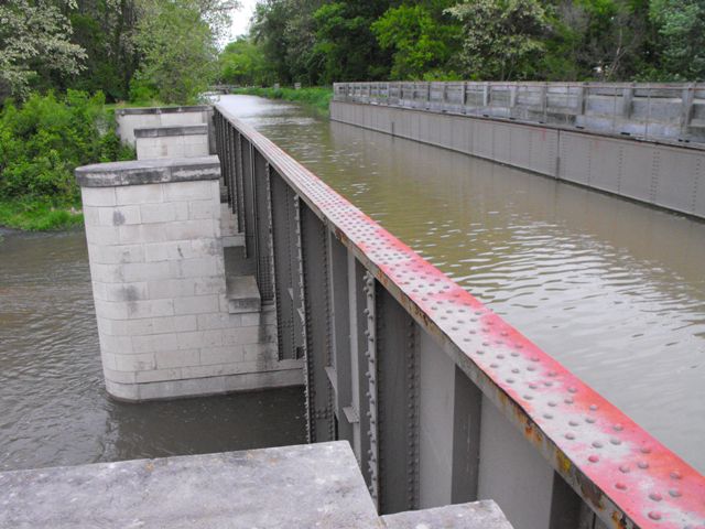
This is one of the most impressive and striking features of the historic Illinois and Michigan Canal, which is designated a National Heritage Corridor. It is an aqueduct that carries the canal over a creek, in other words a bridge carrying water over water. Aqueducts like this were a fact of life in canal construction, but surviving functional examples, particularly in the United States that also retain good historic integrity are rare today. The Fox River Aqueduct also on the Illinois and Michigan Canal is a larger aqueduct, but it no longer carries water, and thus the Aux Sable Creek Aqueduct is a rare chance to see one of the canal's aqueducts function in the way it was originally intended.
The riveted through plate girder aqueduct was built in 1927 to replace a timber structure that had been built in 1848. It appears that the existing 1927 structure reused the 1848 substructure. The piers were extensively repaired in 1948, and a parallel towpath bridge was removed in 1960. Historic American Engineering Record documented the structure in 1986, and at that time the piers had fallen into severe disrepair, with numerous stones missing. Sometime after that date, the piers were extensively rehabilitated and reconstructed with stone in a historically sensitive manner. The superstructure may have been repainted at that time but otherwise it remains in good condition in an unaltered state. A wooden deck arch bridge was also integrated into the piers on the south side of the bridge. HistoricBridges.org did not document this structure, but it may be an attempt to replicate either the towpath bridge or the removed original aqueduct.
![]()
![]()
![]()
Coordinates (Latitude, Longitude):
Search For Additional Bridge Listings:
Bridgehunter.com: View listed bridges within 0.5 miles (0.8 kilometers) of this bridge.
Bridgehunter.com: View listed bridges within 10 miles (16 kilometers) of this bridge.
Additional Maps:
Google Streetview (If Available)
GeoHack (Additional Links and Coordinates)
Apple Maps (Via DuckDuckGo Search)
Apple Maps (Apple devices only)
Android: Open Location In Your Map or GPS App
Flickr Gallery (Find Nearby Photos)
Wikimedia Commons (Find Nearby Photos)
Directions Via Sygic For Android
Directions Via Sygic For iOS and Android Dolphin Browser
USGS National Map (United States Only)
Historical USGS Topo Maps (United States Only)
Historic Aerials (United States Only)
CalTopo Maps (United States Only)

© Copyright 2003-2024, HistoricBridges.org. All Rights Reserved. Disclaimer: HistoricBridges.org is a volunteer group of private citizens. HistoricBridges.org is NOT a government agency, does not represent or work with any governmental agencies, nor is it in any way associated with any government agency or any non-profit organization. While we strive for accuracy in our factual content, HistoricBridges.org offers no guarantee of accuracy. Information is provided "as is" without warranty of any kind, either expressed or implied. Information could include technical inaccuracies or errors of omission. Opinions and commentary are the opinions of the respective HistoricBridges.org member who made them and do not necessarily represent the views of anyone else, including any outside photographers whose images may appear on the page in which the commentary appears. HistoricBridges.org does not bear any responsibility for any consequences resulting from the use of this or any other HistoricBridges.org information. Owners and users of bridges have the responsibility of correctly following all applicable laws, rules, and regulations, regardless of any HistoricBridges.org information.
![]()