

View Information About HSR Ratings
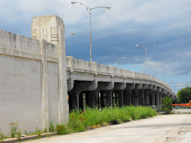
The Laramie Avenue Viaduct was noted as one of the oldest, largest, and most unaltered examples of a highway over railroad viaduct in Cook County. Chicago and the Cook County area is noted for its extremely large number of railroad over highway overpasses, many of them that are very wide, providing drivers with a tunnel-like experience. However, there appears to be a lesser number of bridges where the highway passes over the railroad. Further, many of the highway over railroad structures that remain are either relatively new or have been severely altered. In contrast, the Laramie Avenue Viaduct was constructed in 1939 and yet it retained its original railings and other architectural elements. With the total length of the bridge itself being 841 feet, and a very wide 44.3 foot roadway, this was a notably large structure.
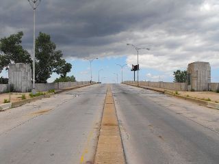
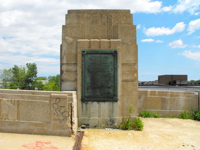
The actual bridge was composed of 20 steel stringer spans. However leading up to those spans at each end was an earthen approach grade that was contained within concrete retaining walls that extended above the roadway to form railings. The retaining walls and railings were designed to match the bridge stylistically, however the width between railings was wider on this approach grade. At the point where the approach grade ended and the bridge began, large decorative concrete pillars on each side of the bridge were present. In true Chicago style, the southeast and northwest pillars contained large grandiose plaques filled with information about the bridge. Crossing the bridge, the bridge grade did not level off for very long in the center, so the experience was one of going up and then immediately descending again. The outermost stringers on the bridge were encased in a decorative concrete veneer that matches up with the railings to create a consistent appearance. The railings themselves were solid concrete with architectural detailing. The stringer spans of the bridge are supported by concrete column bents with caps that have a decorative curved design at the ends. The overall bridge's architectural design was somewhat reminiscent of Art Deco.
The bridge should be considered historically significant as an unaltered example of a large-scale project funded by Federal Depression-related relief funding programs. The plaques on the bridge list the Public Works Administration and President Franklin D. Roosevelt. Morris Handler Company was the contractor for the superstructure, Ready Coal and Construction Company was the contractor for the substructure, and Thomas McQueen Company was the contractor for the approaches. Robert R. Anderson Company did street work for the bridge, and Kil-Bar Electric Company installed the lighting.
Unfortunately, this bridge suffered from extreme deterioration of its concrete column bents. There was severe and widespread spalling present, and emergency shoring had been put in place. By 2010, the bridge had been closed to traffic for safety reasons with plans for demolition and replacement to occur that same year. It is most unfortunate that the bridge was allowed to deteriorate in this manner. The superstructure was actually in decent condition, but the substructure ended up essentially beyond repair. It appears that the deterioration on the bents may have been due to water and particularly winter deicing salts leaking through expansion joints and dripping onto the bents below. This theory was supported by the observation of holes in the deck around the expansion joints, suggesting water was pooling and draining improperly around the joints. Providing a more water-tight form of expansion joint along with appropriate drain pipes to direct water away from the bents, limiting salt application, and/or coating the bents with a protective sealant would have all been possible solutions that could have helped prevent this deterioration from occurring. Now instead, much larger quantities of tax dollars will be spent to replace this bridge, which will also result in the loss of an attractive and noteworthy historic bridge.
HistoricBridges.org does suggest that the earthen approach grade along with its railings and retaining wall, as well as the decorative concrete pillars at the abutments could be left in place, and the replacement bridge simply built to extend from the ends of these approaches. Obviously this is not an optimal preservation solution, but it would be a partial salvage and reuse of the historic structure and would retain a few of the key architectural elements from the structure.

|
Main Plaque FEDERAL WORKS AGENCYPUBLIC WORKS ADMINISTRATION JOHN M. CARMODY FEDERAL WORKS ADMINISTRATOR FRANKLIN D. ROOSEVELT PRESIDENT OF THE UNITED STATES S. LARAMIE AVENUE IMPROVEMENT 1939 BUILT BY THE CITY OF CHICAGO EDWARD J. KELLY, MAYOR BOARD OF LOCAL IMPROVEMENTS JAMES P. BOYLE, PRESIDENT WILLIAM W. LINK, VICE PRESIDENT MEMBERS
ARTHUR ENGH CHIEF ENGINEER CONTRACTORS
MORRIS HANDLER CO. SUPERSTRUCTURE
SEC. S. LARAMIE AVE. - 0808 - C. S. |
![]()


Chicago and Cook County are home to one of the largest collections of historic bridges in the country, and no other city in the world has more movable bridges. HistoricBridges.org is proud to offer the most extensive coverage of historic Chicago bridges on the Internet.
General Chicago / Cook County Bridge Resources
Chicago's Bridges - By Nathan Holth, author of HistoricBridges.org, this book provides a discussion of the history of Chicago's movable bridges, and includes a virtual tour discussing all movable bridges remaining in Chicago today. Despite this broad coverage, the book is presented in a compact format that is easy to take with you and carry around for reference on a visit to Chicago. The book includes dozens of full color photos. Only $9.95 U.S! ($11.95 Canadian). Order Now Direct From The Publisher! or order on Amazon.
Chicago River Bridges - By Patrick T. McBriarty, this is a great companion to Holth's book shown above. This much larger book offers an extremely in-depth exploration of Chicago's movable highway bridges, including many crossings that have not existed for many years. Order Now Direct From The Publisher! or order on Amazon.
View Historic American Engineering Record (HAER) Overview of Chicago Bascule Bridges (HAER Data Pages, PDF)
Chicago Loop Bridges - Chicago Loop Bridges is another website on the Internet that is a great companion to the HistoricBridges.org coverage of the 18 movable bridges within the Chicago Loop. This website includes additional information such as connections to popular culture, overview discussions and essays about Chicago's movable bridges, additional videos, and current news and events relating to the bridges.
Additional Online Articles and Resources - This page is a large gathering of interesting articles and resources that HistoricBridges.org has uncovered during research, but which were not specific to a particular bridge listing.
![]()
![]()
![]()
![]()
![]()
This historic bridge has been demolished. This map is shown for reference purposes only.
This bridge is closed to vehicular traffic and is slated for demolition.
Coordinates (Latitude, Longitude):
Search For Additional Bridge Listings:
Bridgehunter.com: View listed bridges within 0.5 miles (0.8 kilometers) of this bridge.
Bridgehunter.com: View listed bridges within 10 miles (16 kilometers) of this bridge.
Additional Maps:
Google Streetview (If Available)
GeoHack (Additional Links and Coordinates)
Apple Maps (Via DuckDuckGo Search)
Apple Maps (Apple devices only)
Android: Open Location In Your Map or GPS App
Flickr Gallery (Find Nearby Photos)
Wikimedia Commons (Find Nearby Photos)
Directions Via Sygic For Android
Directions Via Sygic For iOS and Android Dolphin Browser
USGS National Map (United States Only)
Historical USGS Topo Maps (United States Only)
Historic Aerials (United States Only)
CalTopo Maps (United States Only)

© Copyright 2003-2024, HistoricBridges.org. All Rights Reserved. Disclaimer: HistoricBridges.org is a volunteer group of private citizens. HistoricBridges.org is NOT a government agency, does not represent or work with any governmental agencies, nor is it in any way associated with any government agency or any non-profit organization. While we strive for accuracy in our factual content, HistoricBridges.org offers no guarantee of accuracy. Information is provided "as is" without warranty of any kind, either expressed or implied. Information could include technical inaccuracies or errors of omission. Opinions and commentary are the opinions of the respective HistoricBridges.org member who made them and do not necessarily represent the views of anyone else, including any outside photographers whose images may appear on the page in which the commentary appears. HistoricBridges.org does not bear any responsibility for any consequences resulting from the use of this or any other HistoricBridges.org information. Owners and users of bridges have the responsibility of correctly following all applicable laws, rules, and regulations, regardless of any HistoricBridges.org information.
![]()