

View Information About HSR Ratings
Additional Information: Construction date, builders, and engineers refer to the original 1925 bascule span.
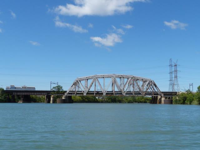
As configured today, this bridge is actually four parallel bridges whose main spans are all truss bridges of the same general design that appear to date to perhaps the 1960s. Three of the truss spans share a single pier and each of these truss spans contain two tracks. Sitting on its own pier is a fourth truss on the eastern side that is more narrow and only carries a single track. Deck girder spans provide an approach to these truss spans. However, some of the approach spans are actually single leaf bascule spans that date to an earlier era of this waterway where movable bridges were needed, and when the waterway would have been more narrow. At that time, the bascule spans would have been the main spans of the bridge. At this time, less railroad tracks appear to have crossed the river as well since not all the bridges have these bascule approach spans. In fact, the configuration is somewhat unusual. When the bascule bridge spans were built, the westernmost bridge was apparently a single track bridge. As a result when the new double-track truss was built, an additional girder span was added to the western side of the bridge to accommodate the wider double track configuration. The two middle truss bridges in contrast both have a double-track bascule approach span. Finally, the eastern single track truss bridge has no bascule span and instead has a fixed plate girder span that is older than the truss spans but obviously newer than the bascule spans (since it is fixed yet offers less clearance that the bascule spans in closed position). As a result of this configuration the bascule spans are somewhat hidden beside the newer girder spans. The newer girder spans are of interest as well however. The westernmost bridge's newer girder spans still retain the United States Steel logo as well as the American Bridge name, both of which were painted on the bridge when built. These were never painted over during their life, which makes them a rather rare sight to see. The names are fading and flaking, but still visible.

In the aerial view from 1959 shown to the above left, at the top portion of the photo this bridge is visible, shown before the river was widened and thus before the truss spans were added. The fixed girder span at the east side has been added, indicating that by 1959, the bascule span, and likely the former Indiana Avenue Bridge (seen in the middle of the photo) no longer operated for boats at this time.
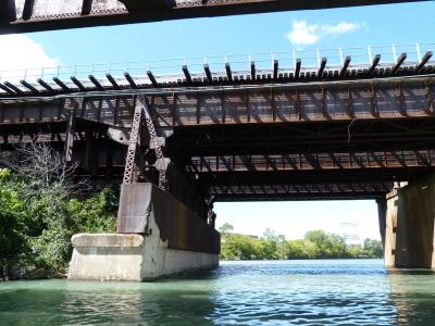
The bascule spans have had much of their operating equipment removed. However, the bascules appear to have been a variation of the fixed trunnion bascule. The racks remain on the bridge, but the pinions and other gears are missing. The counterweights are removed, although the counterweight arms remain.
Thanks to Tom Winkle for providing boat transportation to assist in the photo-documentation of this historic bridge, which made possible the discovery of the bascule spans.
![]()


Chicago and Cook County are home to one of the largest collections of historic bridges in the country, and no other city in the world has more movable bridges. HistoricBridges.org is proud to offer the most extensive coverage of historic Chicago bridges on the Internet.
General Chicago / Cook County Bridge Resources
Chicago's Bridges - By Nathan Holth, author of HistoricBridges.org, this book provides a discussion of the history of Chicago's movable bridges, and includes a virtual tour discussing all movable bridges remaining in Chicago today. Despite this broad coverage, the book is presented in a compact format that is easy to take with you and carry around for reference on a visit to Chicago. The book includes dozens of full color photos. Only $9.95 U.S! ($11.95 Canadian). Order Now Direct From The Publisher! or order on Amazon.
Chicago River Bridges - By Patrick T. McBriarty, this is a great companion to Holth's book shown above. This much larger book offers an extremely in-depth exploration of Chicago's movable highway bridges, including many crossings that have not existed for many years. Order Now Direct From The Publisher! or order on Amazon.
View Historic American Engineering Record (HAER) Overview of Chicago Bascule Bridges (HAER Data Pages, PDF)
Chicago Loop Bridges - Chicago Loop Bridges is another website on the Internet that is a great companion to the HistoricBridges.org coverage of the 18 movable bridges within the Chicago Loop. This website includes additional information such as connections to popular culture, overview discussions and essays about Chicago's movable bridges, additional videos, and current news and events relating to the bridges.
Additional Online Articles and Resources - This page is a large gathering of interesting articles and resources that HistoricBridges.org has uncovered during research, but which were not specific to a particular bridge listing.
![]()
![]()
![]()
Coordinates (Latitude, Longitude):
Search For Additional Bridge Listings:
Bridgehunter.com: View listed bridges within 0.5 miles (0.8 kilometers) of this bridge.
Bridgehunter.com: View listed bridges within 10 miles (16 kilometers) of this bridge.
Additional Maps:
Google Streetview (If Available)
GeoHack (Additional Links and Coordinates)
Apple Maps (Via DuckDuckGo Search)
Apple Maps (Apple devices only)
Android: Open Location In Your Map or GPS App
Flickr Gallery (Find Nearby Photos)
Wikimedia Commons (Find Nearby Photos)
Directions Via Sygic For Android
Directions Via Sygic For iOS and Android Dolphin Browser
USGS National Map (United States Only)
Historical USGS Topo Maps (United States Only)
Historic Aerials (United States Only)
CalTopo Maps (United States Only)

© Copyright 2003-2024, HistoricBridges.org. All Rights Reserved. Disclaimer: HistoricBridges.org is a volunteer group of private citizens. HistoricBridges.org is NOT a government agency, does not represent or work with any governmental agencies, nor is it in any way associated with any government agency or any non-profit organization. While we strive for accuracy in our factual content, HistoricBridges.org offers no guarantee of accuracy. Information is provided "as is" without warranty of any kind, either expressed or implied. Information could include technical inaccuracies or errors of omission. Opinions and commentary are the opinions of the respective HistoricBridges.org member who made them and do not necessarily represent the views of anyone else, including any outside photographers whose images may appear on the page in which the commentary appears. HistoricBridges.org does not bear any responsibility for any consequences resulting from the use of this or any other HistoricBridges.org information. Owners and users of bridges have the responsibility of correctly following all applicable laws, rules, and regulations, regardless of any HistoricBridges.org information.
![]()