

View Information About HSR Ratings
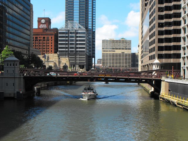
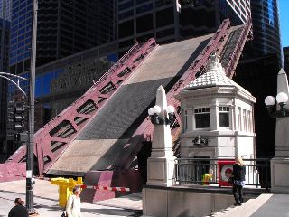
This bridge was the first Chicago bascule bridge to have a smoothly-curved pony truss design for a movable bridge, and was the generation of trunnion bascule bridges that succeeded the somewhat clunky looking bridge design seen on bridges such as Grand Avenue. The Monroe Street Bridge however still has the clunky looking detail at the ends of the trusses like the Grand Avenue type bascules. Later examples of this bridge design would have a more aesthetically pleasing curved detail at the ends in addition to the smoothly curved detail in the center. The Franklin Street Bridge is one such later example.
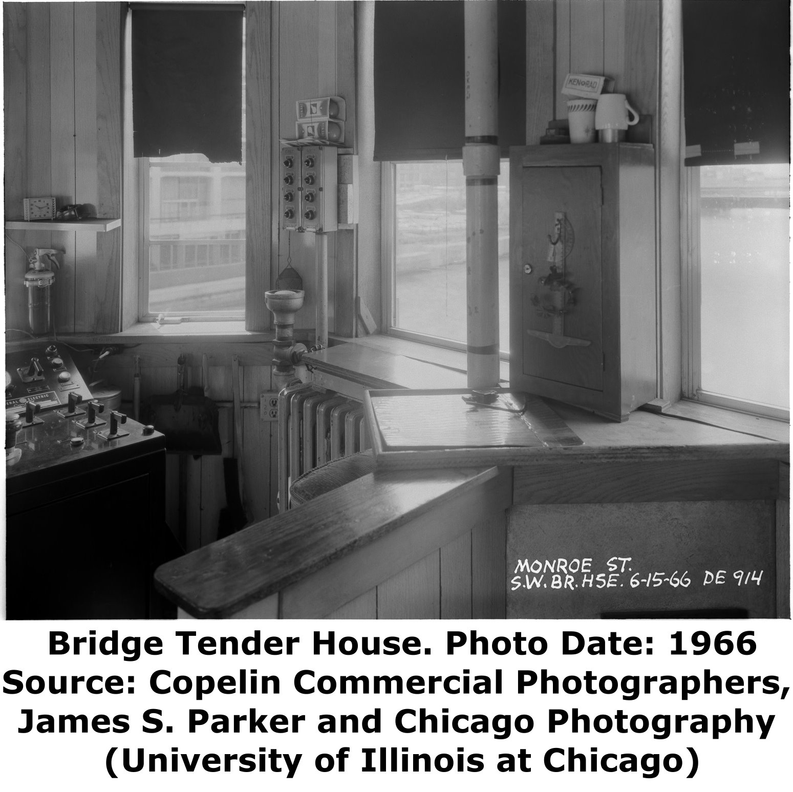
The bridge's operating and control panels inside the bridgetender buildings were reportedly the first in the United States to have completely enclosed circuitry so that no exposed copper connections were available for bridgetenders to mistakenly electrocute themselves on.
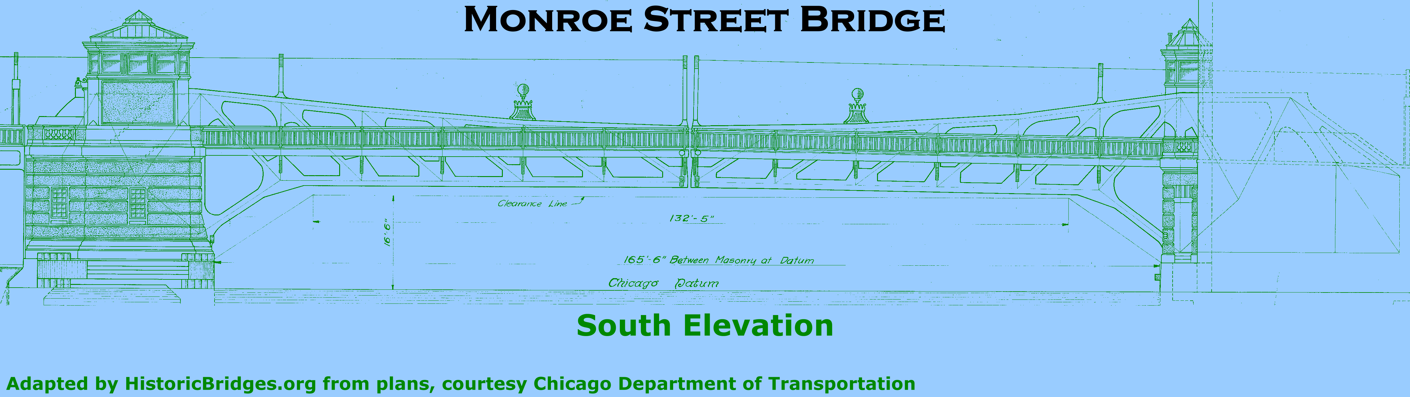
The navigational vertical clearance of the bridge is 18.7 Feet. The clear span of the bridge is 165.5 feet, while the trunnion-to-trunnion length is 193 feet. The bridge is 60 feet wide.

The Monroe Street Bridge is unique because the engineers had to do some very special technical and mechanical design to get this bridge to fit near to Union Station which was under construction at the time and takes up substantial space below the roadway level of Monroe Street. To ensure that room remained for the Union Station underground facilities, the counterweight, which is under the road on this type of bridge, was changed at one end only. At the west end, engineers used a smaller counterweight using heavier cast iron instead of concrete. The east end however had the standard concrete sized counterweight. There is a more technical description of this available in the HAER entry for this bridge.
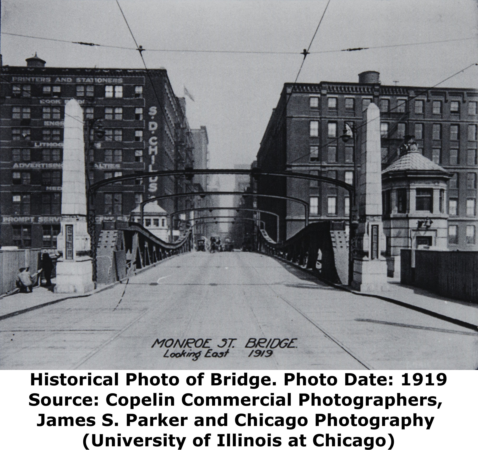
On the western end of the bridge, where the smaller counterweight is used, steel blocks used to help counterweight the bridge actually extend above the deck level and are attached to the ends of the trusses. Some of these blocks may be later additions, but a historical photo of the bridge from 1919 does appear to show some counterweight blocks on this end of the bridge. This is likely further indication of the limited space below the roadway and a creative method the city designed to add weight to this end of the bridge. Sometimes over the course of a bascule bridge's history, counterweights would need to be made heavier or lighter, usually in response to changes made to the deck design. On this bridge, the blocks that rest on the west end of the bridge on top of the top chord, do not appear in the 1919 photo and thus appear to be an example of weights added to the bridge at a later date.
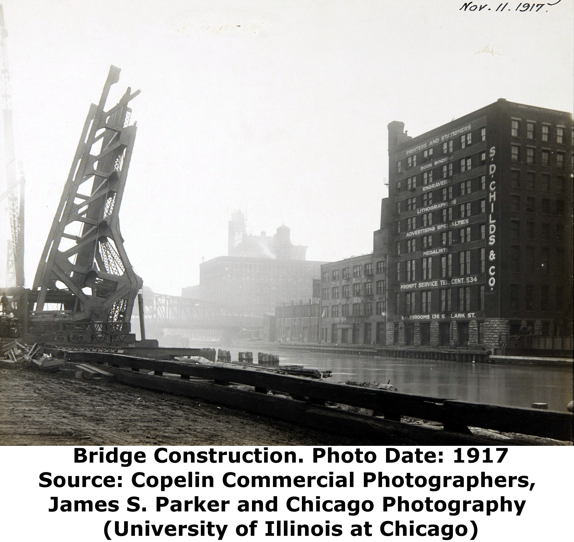
The 1919 photo, shown to the right, also shows unusual concrete pillars at the end of the bridge. These appear to have been decorative, but also appear to have contained a "Stop" signal to alert drivers when the bridge was being raised. The arched overhead beams seen in the photo are for holding the cables for the street cars that once were found on numerous Chicago streets. Many of Chicago's movable bridges originally had these arched overhead beams, but all have been removed today.
|
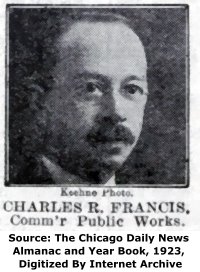
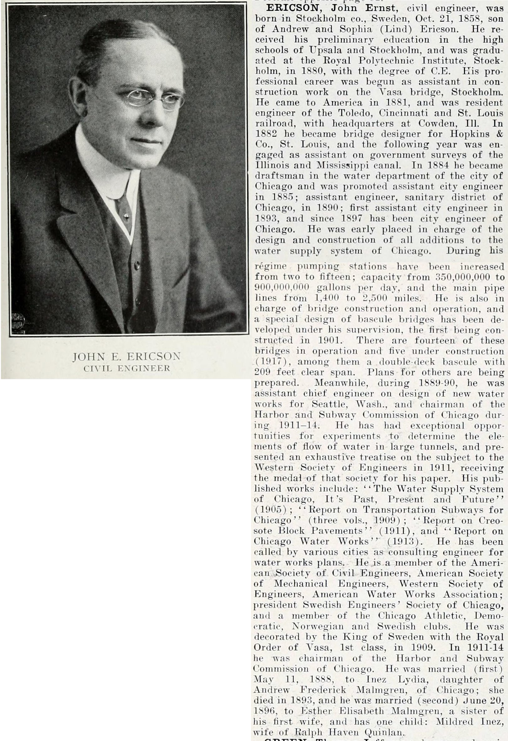
Main Plaque WILLIAM HALE THOMPSONMAYOR CHARLES R. FRANCIS COMMISSIONER OF PUBLIC WORKS WILLIAM BURKHARDT DEPUTY COMMISSIONER OF PUBLIC WORKS JOHN ERICSON CITY ENGINEER THOS. G. PIHLFELDT ENGINEER OF BRIDGES
BUILT BY CHICAGO UNION STATION CO. CHICAGO PLAN COMMISSION ILL. CHAP. AMER. INST. ARCHT'S SUBSTRUCTURE FITZSIMONS & CONNELL D. & D. CO. SUPERSTRUCTURE THE KETLER-ELLIOTT ERECTION CO. THE ELECTRICAL EQUIPMENT INSTALLED BY C. H. NORWOOD 1919 |
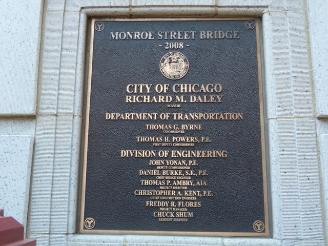
Rehabilitation Plaque MONROE STREET BRIDGE- 2008 - CITY OF CHICAGO RICHARD M. DALEY MAYOR DEPARTMENT OF TRANSPORTATION THOMAS G. BYRNE COMMISSIONER THOMAS H. POWERS, P.E. FIRST DEPUTY COMMISSIONER DIVISION OF ENGINEERING JOHN YONAN, P.E. DEPUTY COMMISSIONER DANIEL BURKE, S.E., P.E. CHIEF BRIDGE ENGINEER THOMAS P. AMBRY, AIA PROJECT DIRECTOR CHRISTOPHER A. KENT, P.E. CHIEF CONSTRUCTION ENGINEER FREDDY R. FLORES PROJECT MANAGER CHUCK SHUM RESIDENT ENGINEER |
![]()


Chicago and Cook County are home to one of the largest collections of historic bridges in the country, and no other city in the world has more movable bridges. HistoricBridges.org is proud to offer the most extensive coverage of historic Chicago bridges on the Internet.
General Chicago / Cook County Bridge Resources
Chicago's Bridges - By Nathan Holth, author of HistoricBridges.org, this book provides a discussion of the history of Chicago's movable bridges, and includes a virtual tour discussing all movable bridges remaining in Chicago today. Despite this broad coverage, the book is presented in a compact format that is easy to take with you and carry around for reference on a visit to Chicago. The book includes dozens of full color photos. Only $9.95 U.S! ($11.95 Canadian). Order Now Direct From The Publisher! or order on Amazon.
Chicago River Bridges - By Patrick T. McBriarty, this is a great companion to Holth's book shown above. This much larger book offers an extremely in-depth exploration of Chicago's movable highway bridges, including many crossings that have not existed for many years. Order Now Direct From The Publisher! or order on Amazon.
View Historic American Engineering Record (HAER) Overview of Chicago Bascule Bridges (HAER Data Pages, PDF)
Chicago Loop Bridges - Chicago Loop Bridges is another website on the Internet that is a great companion to the HistoricBridges.org coverage of the 18 movable bridges within the Chicago Loop. This website includes additional information such as connections to popular culture, overview discussions and essays about Chicago's movable bridges, additional videos, and current news and events relating to the bridges.
Additional Online Articles and Resources - This page is a large gathering of interesting articles and resources that HistoricBridges.org has uncovered during research, but which were not specific to a particular bridge listing.
This bridge is tagged with the following special condition(s): Unorganized Photos
![]()

![]()
![]()
![]()
![]()

![]()
![]()

![]()
![]()
![]()
![]()
Coordinates (Latitude, Longitude):
Search For Additional Bridge Listings:
Bridgehunter.com: View listed bridges within 0.5 miles (0.8 kilometers) of this bridge.
Bridgehunter.com: View listed bridges within 10 miles (16 kilometers) of this bridge.
Additional Maps:
Google Streetview (If Available)
GeoHack (Additional Links and Coordinates)
Apple Maps (Via DuckDuckGo Search)
Apple Maps (Apple devices only)
Android: Open Location In Your Map or GPS App
Flickr Gallery (Find Nearby Photos)
Wikimedia Commons (Find Nearby Photos)
Directions Via Sygic For Android
Directions Via Sygic For iOS and Android Dolphin Browser
USGS National Map (United States Only)
Historical USGS Topo Maps (United States Only)
Historic Aerials (United States Only)
CalTopo Maps (United States Only)

© Copyright 2003-2024, HistoricBridges.org. All Rights Reserved. Disclaimer: HistoricBridges.org is a volunteer group of private citizens. HistoricBridges.org is NOT a government agency, does not represent or work with any governmental agencies, nor is it in any way associated with any government agency or any non-profit organization. While we strive for accuracy in our factual content, HistoricBridges.org offers no guarantee of accuracy. Information is provided "as is" without warranty of any kind, either expressed or implied. Information could include technical inaccuracies or errors of omission. Opinions and commentary are the opinions of the respective HistoricBridges.org member who made them and do not necessarily represent the views of anyone else, including any outside photographers whose images may appear on the page in which the commentary appears. HistoricBridges.org does not bear any responsibility for any consequences resulting from the use of this or any other HistoricBridges.org information. Owners and users of bridges have the responsibility of correctly following all applicable laws, rules, and regulations, regardless of any HistoricBridges.org information.
![]()