

View Information About HSR Ratings
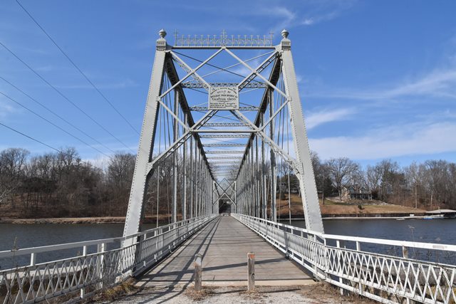
Whipple truss bridges of any kind are rare, but multi-span examples are particularly rare. This outstanding example is even more notable for its beautiful ornamentation. In 2011 this bridge was restored for pedestrian use only, and much of the portal cresting which was damaged was restored and replicated. The genuine riveted railing on the bridge is also new, but respective of historic design.

Information and Findings From DHPA Historic Bridge SurveyStatement of Significance The crossing of the Tippecanoe River near the Paper Mill just south of Monticello at the county line on the road to Delphi had been bridged since at least the last quarter of the nineteenth century. The White county board of commissioners responded to William Spencer's petition for a bridge in March 1880 and sought the cooperative aid of the Carroll county board. The Carroll county board "did not reply" to the White county inquiry. Without Carroll county help, the White county commissioners had to go it alone and decided in December 1881 to construct a bridge for something under $3,000. In May 1882, the board agreed to specifications for a wooden or combination bridge "supported by wooden piers and abutments." The Massillon Bridge Company was the "lowest and best responsible bidder" for the whole of the new bridge in June. The structure was complete by January 1883 at a cost of $5,800. The timber piers became a regular problem. In June the board added ice-breakers to the piers and fill around them in. In September it hired Horatio Thornton to make $1,900 in repairs to the piers. The superstructure required some repairs, too. In June 1889, the boards of commissioners of White and Carroll counties finally met together to consider the state of the existing bridge. The meeting was prompted in part by S. Randall Cowger's claims as represented by legal counsel against the two counties. Although the boards rejected Cowger's claims, they did appoint their surveyor-engineers to examine the bridge and to propose repairs. (Cowger's attorneys successfully pursued their claims against the counties in court: Carroll county ultimately paid $500 of the judgment against them.) In July, the joint boards received their county engineers' condemnation of the old bridge as unsafe and asked them-- Craven Smith of Carroll county and Alfred R. Orton of White county--to prepare plans and specifications for a new structure. A month later the boards received the recommendation for a "single intersection wrought iron truss bridge" with a capacity of 1,120 lbs. per lineal foot and with a 16-ft. roadway, "the same to rest on abutments and piers of Oolitic limestone." Letting was set for September in Delphi. At it, decisions leading to false starts and major conflicts were taken. John C. O'Connor of Delphi won the contract to construct the stone abutments and pier with John B. Ellis named to superintend their building and A. R. Orton to locate them. For reasons unstated, Orton resigned as engineer of construction in October, and the boards named Webster P. Bushnell in his stead. The boards also decided to locate the new bridge at the site of the old one, and they allowed O'Connor to use Buffalo or equivalent cement instead of Portland. After a December inspection, the joint boards declared that the construction of the substructure was "not being done according to the contracts heretofore made" and then fired superintendents Bushnell and Ellis. Craven Smith was named project engineer. O'Connor, in turn, offered to surrender all rights, title, and interest "in the materials furnished" for the substructure for an addition of $3,000 to his contract and agreed to "take down" his construction and "rebuild as provided in said contract." Craven estimated that the value of the materials at $5,000. The joint boards agreed to O'Connor's proposal. This second start was not the last. In August 1890, Craven Smith reported "doubt as to the sufficiency of the pier" and "to its being properly constructed according to plans and specifications." The boards ordered the engineer "to take down so much of the same as shall be necessary to determine whether said work has been properly constructed." In September Smith reported on the completed substructure which he assessed at $12,033.80. The boards agreed to pay $4,488.98. In protest, O'Connor brought a suit against the county boards in the Cass County Circuit Court and won. Rather than concede, the boards appealed to the state supreme court, where O'Connor was vindicated again and secured an award of $13,826.45. At the September 1889 letting, the Columbia Bridge Company of Dayton, Ohio, brought in the "lowest and best" bid for the superstructure. In June 1890, however, C. C. Morrison, president of the Columbia Bridge Company, asked to surrender their contract. The boards agreed. They also reaffirmed the specifications except they now specified two spans of 225 ft. each. The Wrought Iron Bridge Company of Canton, Ohio, secured the superstructure contract in place of Columbia Bridge. With the superstructure complete by January 1891, the boards paid WIBCo $10,500 for their iron work. Each span of the pinned, double-intersection, Pratt--or Whipple--through-truss structure extends 225 ft. subdivided into fifteen panels. The heavy end-posts and top-chord are made of crafted channels--a pair of angles and plate riveted together--cover plate, and battens. A pair of die- forged eyebars supply most lower-chord members. At the outer two panels, though, the eyebars are stiffened with ribbon-lacing riveted between them. Eyebars hang as hip verticals; the intermediate ones rely on four sizes of laced channels (decreasing in size toward center span). Most diagonals are double eyebars. A pair of adjustable, cylindrical rods double in the three most central panels as diagonals and counters. To stiffen the high trusses, the portals carry deep braced-X struts made of a pair of ribbon-laced bars. The intermediate struts consist of latticed bars. Adjustable round rods help to stiffen the structure in a number of ways--as upper and lower lateral braces and as horizontal struts placed about halfway between the chords and from vertical to vertical to vertical. U-bolted to the lower pins, I floor-beams support the rolled I-beam stringers. Together, the beams and stringers carry the 16-ft. timber roadway. Although the original timber hub-guards are long gone, the highly decorative cresting and finials remain. The Tioga Bridge's pier was a continuing problem. In 1898, the joint boards decided to place iron bands around it and to repoint the stone. In 1901, the boards hired James M. Peirce of Delphi to rebuild the pier. At the same time, the bridge was re-floored and painted by others. Considered locally as "the most unique and oldest bridge in White County," it was a postcard landmark by early in the twentieth century. It sits on a major thoroughfare for two counties which has been bridged over the Tippecanoe River for some time. The substructure was built by a noted Carroll county stone mason and rebuilt by a second regionally-important one. The superstructure is the longest of a handful of Whipple-trusses remaining in the state The trusses retain their original members and still carry most of their unusually decorative over-the-portal cresting and finials. Other Information References Schlegelmilch and Assoc., Bridge Inspection Report: White County (Monticello, 1973). Donald W. Ward, Bridge Reinspection Report: White County (Monticello, 1980, 1996). bridge nameplate. Indiana Historic Sites & Structures Inventory, Carroll County Interim Report (Indianapolis, 1980), 33-34. Indiana State Highway Commission, "Bridge Survey," 642: 26. Carroll County, "Commissioners Record," 16: 576-577, 584; 17: 9-10, 71-73, 77, 163-164, 256, 258, 262, 367-369, 373-374, 385-386, 392, 428, 430-433, 492-495; 18: 56. White County, "Commissioners Record," 8: 59, 112, 148, 183, 216, 298, 316-317, 356, 367, 370; 9: 452-453, 459, 463, 470-471, 490-491, 495, 524-525, 561; 10: 4-5, 14, 33-39, 60-62, 114-115, 482-483; 11: 481; 12: 198, 229, 281, 290, 296, 328, 341. Bridge Considered Historic By Survey: Yes |
![]()
![]()
![]()
Coordinates (Latitude, Longitude):
Search For Additional Bridge Listings:
Bridgehunter.com: View listed bridges within 0.5 miles (0.8 kilometers) of this bridge.
Bridgehunter.com: View listed bridges within 10 miles (16 kilometers) of this bridge.
Additional Maps:
Google Streetview (If Available)
GeoHack (Additional Links and Coordinates)
Apple Maps (Via DuckDuckGo Search)
Apple Maps (Apple devices only)
Android: Open Location In Your Map or GPS App
Flickr Gallery (Find Nearby Photos)
Wikimedia Commons (Find Nearby Photos)
Directions Via Sygic For Android
Directions Via Sygic For iOS and Android Dolphin Browser
USGS National Map (United States Only)
Historical USGS Topo Maps (United States Only)
Historic Aerials (United States Only)
CalTopo Maps (United States Only)

© Copyright 2003-2024, HistoricBridges.org. All Rights Reserved. Disclaimer: HistoricBridges.org is a volunteer group of private citizens. HistoricBridges.org is NOT a government agency, does not represent or work with any governmental agencies, nor is it in any way associated with any government agency or any non-profit organization. While we strive for accuracy in our factual content, HistoricBridges.org offers no guarantee of accuracy. Information is provided "as is" without warranty of any kind, either expressed or implied. Information could include technical inaccuracies or errors of omission. Opinions and commentary are the opinions of the respective HistoricBridges.org member who made them and do not necessarily represent the views of anyone else, including any outside photographers whose images may appear on the page in which the commentary appears. HistoricBridges.org does not bear any responsibility for any consequences resulting from the use of this or any other HistoricBridges.org information. Owners and users of bridges have the responsibility of correctly following all applicable laws, rules, and regulations, regardless of any HistoricBridges.org information.
![]()