

View Information About HSR Ratings
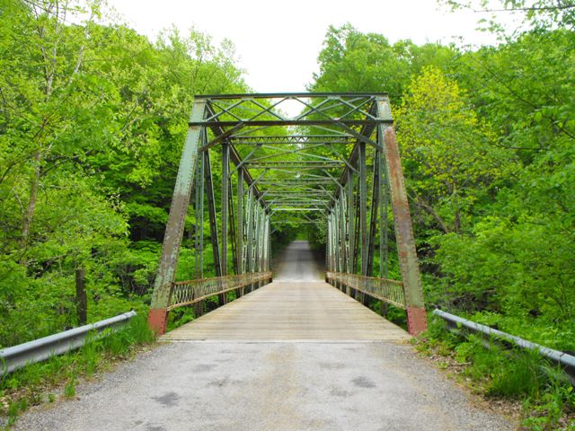
This bridge is an eight panel through truss with 18.5 feet of vertical clearance. It is a traditionally composed example of its kind which has become increasingly uncommon in Indiana. The bridge, which sits on fairly tall concrete abutments which offers a good deal of height above the river, retains good historic integrity including original railings. The bottom chord retains integrity, but has been supplemented with post-tensioning in the form of cable.
Information and Findings From DHPA Historic Bridge SurveyStatement of Significance Riveted Pratt through spans are not common in Indiana. The crafting of the verticals and the placement of the floor beams are also interesting. The bridge retains its original members, including the latticed guardrails. Architectural Description Seated upon concrete abutments and wingwalls, this riveted Pratt through span extends 140' in eight panels. Crafted I beams provide the intermediate verticals, and a pair of angles riveted together with battens supplies the diagonals and counters. Only the two most central panels are countered. The I floor beams are riveted to the verticals and gussets above the lower chord. The bridge carries an asphalt and metal pan deck with a 16' roadway and 18'6" of vertical clearance. Bridge Considered Historic By Survey: Yes |
![]()
![]()
![]()
Coordinates (Latitude, Longitude):
Search For Additional Bridge Listings:
Bridgehunter.com: View listed bridges within 0.5 miles (0.8 kilometers) of this bridge.
Bridgehunter.com: View listed bridges within 10 miles (16 kilometers) of this bridge.
Additional Maps:
Google Streetview (If Available)
GeoHack (Additional Links and Coordinates)
Apple Maps (Via DuckDuckGo Search)
Apple Maps (Apple devices only)
Android: Open Location In Your Map or GPS App
Flickr Gallery (Find Nearby Photos)
Wikimedia Commons (Find Nearby Photos)
Directions Via Sygic For Android
Directions Via Sygic For iOS and Android Dolphin Browser
USGS National Map (United States Only)
Historical USGS Topo Maps (United States Only)
Historic Aerials (United States Only)
CalTopo Maps (United States Only)

© Copyright 2003-2024, HistoricBridges.org. All Rights Reserved. Disclaimer: HistoricBridges.org is a volunteer group of private citizens. HistoricBridges.org is NOT a government agency, does not represent or work with any governmental agencies, nor is it in any way associated with any government agency or any non-profit organization. While we strive for accuracy in our factual content, HistoricBridges.org offers no guarantee of accuracy. Information is provided "as is" without warranty of any kind, either expressed or implied. Information could include technical inaccuracies or errors of omission. Opinions and commentary are the opinions of the respective HistoricBridges.org member who made them and do not necessarily represent the views of anyone else, including any outside photographers whose images may appear on the page in which the commentary appears. HistoricBridges.org does not bear any responsibility for any consequences resulting from the use of this or any other HistoricBridges.org information. Owners and users of bridges have the responsibility of correctly following all applicable laws, rules, and regulations, regardless of any HistoricBridges.org information.
![]()