HistoricBridges.org Menu: HistoricBridges.org Menu:


We Recommend:
Bach Steel - Experts at historic truss bridge restoration.

HistoricBridges.org: Bridge Browser

Angela Boulevard Bridge

Angela Avenue Bridge

Angela Boulevard Bridge

Primary Photographer(s): Nathan Holth

Bridge Documented: October 1, 2006 and April 20, 2014

View Photos
and Videos
View Maps
and Links

Facility Carried / Feature Intersected
Angela Boulevard Over St. Joseph River
Location
South Bend: St. Joseph County, Indiana: United States
Construction Date and Builder / Engineer
1940 By Builder/Contractor: H. L. Maddocks Company and Engineer/Design: William S. Moore
Rehabilitation Date
2004
Main Span Length
79.7 Feet (24.3 Meters)
Structure Length
257.0 Feet (78.3 Meters)
Roadway Width
39.7 Feet (12.1 Meters)
Spans
3 Main Span(s)
Inventory Number
7100002

Historic Significance Rating (HSR)
View Information About HSR Ratings

Bridge Documentation

View Archived National Bridge Inventory Report - Has Additional Details and Evaluation

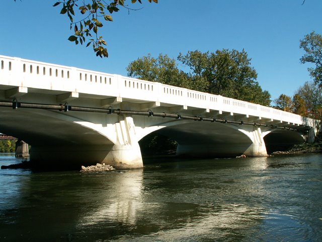
This bridge is one of a number of remaining concrete deck arch bridges in South Bend. This one is significant for documented association with federal aid as a part of Depression-era programs. Plaques remain on the bridge, listing the road as Angela Avenue and displaying the Public Works Administration. These plaques are a standard design that came from the federal level, and were used on many Depression-era bridges, including Elkhart's Bridge Street Bridge, which was also built by the same contactor. The Indian Trail Bridge in St. Clair County, Michigan also used these plaques, demonstrating that the plaque design was a federal standard, and not restricted to a particular state.

Information and Findings From DHPA Historic Bridge Survey

Statement of Significance

The Federal Government made it possible for Saint Joseph County to build this structure. Designed by a leading regional engineer, it was one of the very few bridges to be constructed in South Bend during the Depression. It is quite long and unusually well decorated. The bridge retains its architectural and structural integrity.

Architectural Description

As the Great Depression gripped the United States, Indiana's counties increasingly shifted their inadequate resources from construction to welfare. Many counties stopped building bridges altogether. The cities were more likely to continue a limited program of construction on high-priority sites. This bridge is one of approximately two dozen reinforced concrete filled-spandrel arches built in Indiana cities from 1930-1941. In this case the Federal Works Agency of the Public Works Administration underwrote the cost of construction.

William S. Moore and F.J. Miller designed this 268' structure, and H.L. Maddocks Company built it. It consists of three 80' spans with rather flat three-centered rings springing from about 12' up on the piers. Cantilevered 3' beyond the spandrel walls, brackets support the sidewalks which flank the 38'10" asphalt-over-concrete roadway. Coped and balustraded parapet walls enclose the deck's sides. The piers are also decorated.

Two bridge plates:
1] "Board of County Commissioners / 1940 / Leo Casaday, J.M. Bowen, W.G. Eckler / County Auditor - N.A. Muszer / County Attorney - George Sands / County Engineer - T.J. Dumont / Engineers - William S. Moore, F.J. Miller / Contractor - H.L. Maddocks Co."
2] "Angela Boulevard Bridge / Reconstructed 2003 / St. Joseph County, Indiana / Commissioners: Mark A. Dobson - Dist. 1; Beverly D. Crone - Dist. 2; David L. Niezgodski, Cynthia A. Bodle - Dist. 3; Joseph F. Nagy, Michael C. Eby - Auditor; Susan D. Al-Abbas, Engineer / County Council: W. Randall Przybysz - Dist. A; Henry J. Keultjes - Dist. B; Andrew T. Kostielney, Dale R. Devon - Dist. C; Rafael Morton - Dist. D; David L. Neizgodski - Dist. E; Michael J. Kruk, Dennis R. Schaefer - Dist. F; Mark A. Catanzarite - Dist. G; Joseph A. Baldoni - Dist. H; James A. Reinholtz - Dist. I / Engineering Consultant - Bernardin, Lochmueller & Associates, Inc / Contractor - Superior Construction Co., Inc."

Bridge Considered Historic By Survey: Yes


This bridge is tagged with the following special condition(s): Unorganized Photos

Divider

Photo Galleries and Videos: Angela Boulevard Bridge


View Photo Gallery

2006 Bridge Photo-Documentation

Original / Full Size Photos
A collection of overview and detail photos. This gallery offers photos in the highest available resolution and file size in a touch-friendly popup viewer.
Alternatively, Browse Without Using Viewer

Divider

View Photo Gallery

2006 Bridge Photo-Documentation

Mobile Optimized Photos
A collection of overview and detail photos. This gallery features data-friendly, fast-loading photos in a touch-friendly popup viewer.
Alternatively, Browse Without Using Viewer

Divider

View Photo Gallery

2014 Additional Unorganized Photos

Original / Full Size Photos
A supplemental collection of photos that are from additional visit(s) to the bridge and have not been organized or captioned. This gallery offers photos in the highest available resolution and file size in a touch-friendly popup viewer.
Alternatively, Browse Without Using Viewer

Divider

View Photo Gallery

2014 Additional Unorganized Photos

Mobile Optimized Photos
A supplemental collection of photos that are from additional visit(s) to the bridge and have not been organized or captioned. This gallery features data-friendly, fast-loading photos in a touch-friendly popup viewer.
Alternatively, Browse Without Using Viewer

Divider

Maps and Links: Angela Boulevard Bridge

Coordinates (Latitude, Longitude):

Search For Additional Bridge Listings:

Bridgehunter.com: View listed bridges within 0.5 miles (0.8 kilometers) of this bridge.

Bridgehunter.com: View listed bridges within 10 miles (16 kilometers) of this bridge.

HistoricBridges.org Bridge Browser: View listed bridges within 0.5 miles (0.8 kilometers) of this bridge.

HistoricBridges.org Bridge Browser: View listed bridges within 10 miles (16 kilometers) of this bridge.

2021 National Bridge Inventory: View listed bridges within 0.5 miles (0.8 kilometers) of this bridge.

Additional Maps:

Google Maps

Google Streetview (If Available)

Bing Maps

OpenStreetMap

GeoHack (Additional Links and Coordinates)

Apple Maps (Via DuckDuckGo Search)

Apple Maps (Apple devices only)

MapQuest

HERE We Go Maps

ACME Mapper

Waze Map

Android: Open Location In Your Map or GPS App

Flickr Gallery (Find Nearby Photos)

Wikimedia Commons (Find Nearby Photos)

Directions Via Sygic For Android

Directions Via Sygic For iOS and Android Dolphin Browser

USGS National Map (United States Only)

Historical USGS Topo Maps (United States Only)

Historic Aerials (United States Only)

CalTopo Maps (United States Only)


Divider
 
Home Top

Divider

About - Contact

© Copyright 2003-2024, HistoricBridges.org. All Rights Reserved. Disclaimer: HistoricBridges.org is a volunteer group of private citizens. HistoricBridges.org is NOT a government agency, does not represent or work with any governmental agencies, nor is it in any way associated with any government agency or any non-profit organization. While we strive for accuracy in our factual content, HistoricBridges.org offers no guarantee of accuracy. Information is provided "as is" without warranty of any kind, either expressed or implied. Information could include technical inaccuracies or errors of omission. Opinions and commentary are the opinions of the respective HistoricBridges.org member who made them and do not necessarily represent the views of anyone else, including any outside photographers whose images may appear on the page in which the commentary appears. HistoricBridges.org does not bear any responsibility for any consequences resulting from the use of this or any other HistoricBridges.org information. Owners and users of bridges have the responsibility of correctly following all applicable laws, rules, and regulations, regardless of any HistoricBridges.org information.

Admin Login

Divider