

View Information About HSR Ratings
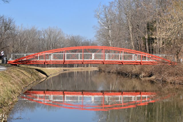
This rare cast and wrought iron bowstring truss bridge is a beautiful centerpiece to this park area. It has a detailed history outlined by Dr. James Cooper's notes below. The history of the bridge may explain some unusual details in the floorbeam design and the use of lattice in the verticals/outriggers that may be somewhat unexpected in this early King Bridge Company bowstring.
Information and Findings From DHPA Historic Bridge SurveyCurrent Location Information For previous Montgomery County locations of superstructure, see Montgomery County Bridge #49 (Blair Ford/Big Jim Bridges). Indianapolis Greenways Location King's patented bowstrings have become very rare in Indiana. This one had been reworked several times. In its latest move and restoration, several changes have been made. The superstructure is new and of concrete rather than stone. The trusses retain their original members. They have been repaired rather than replaced. The floor-beams, stringers, and deck are replacements. The lower lateral bracing uses original rods configured in a single system modeled on King's conventional pattern. The design of the current railings represent the contemporary aesthetic of an architectural firm and has no relation--even at the level of symbol--to historic bridge usage. Previous Locations Information Montgomery County Location: Sugar Creek Having received official notification that Crawfordsville citizens had raised $1,500 by subscription and the promise of an additional $150 of fill by the Crawfordsville and Waynestown Gravel Road Company to erect a bridge over Rock or Sugar Creek near Blair's Pork House on the northwest side of town, the Montgomery board of county commissioners in June 1873 agreed to build and advertised for bids. Among those they received were two from Ohio firms for wrought iron bowstrings that caught their interest--one from the Massillon Bridge Company and the other from the King Iron Bridge and Manufacturing Company of Cleveland. The board decided to entrain for Indianapolis where they visited some of Davenport's Massillon Bridge Company spans which had been erected in Marion county. They probably inspected the spans on Central Avenue over Fall Creek, one of which was later moved near Martinsville as the Burton Lane Bridge. The site visits apparently confirmed the commissioners belief "that the bridge manufactured by Z. King is the best and most durable one of these bridges," and on the 13th of August they contracted with King's Company through R. W. Opp, its agent. The county bought "a wrought iron tubular arch bridge of Z. King's latest improved patent." The structure was to consist of two 90-ft. spans with a 16-ft. roadway together "warranted to sustain 2,000 lbs. per lineal foot" and to cost $22 per foot. The arched top chord would be consist of a pair of 6-in. iron channels throughout and a third channel in the end 20-ft. of each. To "prevent vibrations" and construct "a heavy bridge," King was required to put "two squares of truss over head"--thus turning the spans into through- trusses--and to install lateral bracing under the floors. The agreement specified joists or stringers of "good sound white oak lumber" (2.5"x12") with a riding surface of white oak (2.5" thick) laid diagonally. Thomas Slattery of Crawfordsville secured the contract to built the stone abutments and pier of "rock from Putnam or Parke counties ... of the best kind of sand or limestone" at $10 per cubic yard. Troubles soon surfaced with the Blair Ford Bridge. A flood in the summer of 1875 damaged the substructure of several bridges along Sugar Creek, including the south abutment of Blair Ford. The board received a number of emergency bids for repair. Instead of accepting any, it appointed Thomas Slattery as superintendent of repair. Slattery and Richard Epperson remade the abutment over the course of the fall. While it's not clear the Blair Ford Bridge was involved, Slattery's superintendence combined with work on some of the Sugar Creek bridge repairs led to conflict with the commissioners over his measurements and consequent charges that had to be arbitrated. Despite King's promises that he had designed "a heavy bridge," the Blair Ford structure which accommodated animals driven across it and carried quite heavy loads out of the Pork House and other industries in the area proved more flexible that residents experienced with comfort. In 1877, the commissioners turned to another Ohio firm--the Wrought Iron Bridge Company--to repair King's all-too-swinging spans. The $485 contract which Solomon Godman negotiated for the WIBCo must have involved some substantial work on the superstructure. The reference to a credit to the county of $35 for old iron which WIBCo removed from the bridge makes it clear that structural remodelling was undertaken. WIBCo may have replaced star-iron verticals at the quarter-points of each truss with the stiffer latticed ones and the rolled I-beam floor-beams there with variable-depth girders. They must have been responsible for the second system of lower lateral bracing, and they may have reinforced the timber joists with some rolled wrought iron stringers. WIBCo's remodelling did not apparently stiffen the trusses enough to keep the superstructural movement from damaging the stone substructure. Periodic repairs needed to be made to the substructure along with episodic efforts to reform the superstructure. In Crawfordsville, the bridge began to take on a new name. After Blair had sold the Pork House to others, his name gradually lost relational value in the community, and the regular motion and its consequences of the bowstring led residents to point their fingers at the perpetrators of what was increasingly regarded as a public fiasco--to the county commissioners and auditor who bought this bridge in the first place, all of whom were named Jim, and hence the name "Big Jim Bridge." "There was a sudden crash followed by a loud splash yesterday 13 June 1893 as a portion of the middle pier at the iron bridge gave away and a amass of crumbing stone fell into Sugar creek. At the same instant the south east corner of the north span dropped almost to the water's level and the structure, which has been condemned and considered unsafe for years, was ready for repairs." "The iron bridge was never held in high esteem by the general public and can perhaps be awarded the honors as being the worst deal, in bridge building at least, in the history of the county." The journalistic pundits in Crawfordsville found plenty of blame to go around. In addition to the commissioners and auditor, a number singled out Thomas Slattery for poor stone work. Some of the comment had a religious and ethnic flavor to it, Slattery being of Irish descent and Roman Catholic persuasion who lived near the poor house north of Sugar Creek in the Catholic precincts while finger-pointers lived south of the creek and were likely to have been Presbyterians and from among the city's elite. Montgomery County Location: Lye Creek In any case, the commissioners quickly decided to build a new single-span structure across Sugar Creek and to pull the old bowstrings out of the creek for use in less-traveled parts of the county. Commissioner John W. Fullen negotiated a contract with Patrick Slattery for $175 to remove the spans from the creek-bed, dismantle and match-mark its pieces, being careful to "preserve all bolts and taps not suffering a single one to be lost." Three days before the Big Jim Bridge fell, the board had received Township Trustee William H. Ermantrout's petition for a bridge over Lye Creek on a road between the Darlington and Potato Creek Gravel Road and the Crawfordsville and Potato Creek Gravel Road. The board agreed to the request and authorized the trustee "to erect a suitable and substantial wooden bridge at a reasonable cost." After Big Jim fell, "wooden" was crossed out in the Record and "iron" substituted. William F. Hunt, county surveyor/engineer, reported in January 1894 that Trustee Ermantrout's contract with Thomas Slattery to build a stone substructure for a "wagon road bridge" over Lye Creek at Pitman's Ford had been completed, and the board agreed to pay Slattery $278.47 for his work. Ermantrout oversaw the moving and re-erection of one span of the Big Jim Bridge over Lye Creek, completed by September 1894. As erected over Lye Creek, the pin-connected, 90-ft. pony trusses consisted of nine panels demarked with star-iron verticals and sway braces (in the center panels) bolted above through the arched top chord and below through the lower chord (vertical) or to the floor beam (in the center panels where there are braces). Architectural Description As noted earlier, the vertical-braces at quarter-truss points are made of latticed angles. Round rod, bolted and therefore adjustable through their ends, provide diagonals and counters. The arched top chord is made of a pair of channels--a third being added towards the ends--all riveted to cover plates. Pairs of rectangular die-forged bars extended through the cast-iron shoes of the arch serve as a lower chord. The original I floor-beams and the variable-depth girder ones substituted at quarter-truss points sit upon the lower chord. When moved to Lye Creek, WIBCo's reinforcing wrought iron stringers were retained while the timber joists were scrapped for steel rolled I-beams. A new timber deck carried the 16-ft. roadway. Big Jim's double-system of lower lateral bracing was confusingly reinstalled at Lye Creek. Both the overhead bracing and whatever railings the original spans had were omitted. Indianapolis Greenways Location King's patented bowstrings have become very rare in Indiana. This one had been reworked several times. In its latest move and restoration, several changes have been made. The superstructure is new and of concrete rather than stone. The trusses retain their original members. They have been repaired rather than replaced. The floor-beams, stringers, and deck are replacements. The lower lateral bracing uses original rods configured in a single system modeled on King's conventional pattern. The design of the current railings represent the contemporary aesthetic of an architectural firm and has no relation--even at the level of symbol--to historic bridge usage. See Marion County, Indianapolis Greenways, Imdianapolis Museum of Art. Other Information References Butler, Fairman and Seufert, Inc., Bridge Inspection/Reinspection Report: Montgomery County (Indianapolis, 1973, 1978). bridge nameplate now removed. "The 'Jim' Bridge Goes Down," The Crawfordsville Review, 17 June 1893: 4. Crawfordsville Star, 27 September 1888: 1. "Down Went the Bridge," "Will Build a New Bridge," "What Caused It," "The 'Jim' Bridge," The Daily Argus News (Crawfordsville), 14 June 1893: 2; 15 June 1893: 2; 24 June 1893: 6; 26 June 1893: 2. Indiana Historic Sites & Structures Inventory, Montgomery County: Interim Report (Indianapolis, 1986), 3, 5. Montgomery County, "Commissioners Record," 7: 521, 526-529, 533, 565, 570, 578, 597, 602, 613, 618; 8: 13, 32, 37, 312-314, 318, 366-369, 413, 415, 420; 9: 269-270, 366; 10: 238, 267, 297; 15: 372; 18: 232; 20: 495-498; 20: 453; 21: 57, 196. Ohio Department of Transportation, Ohio Historic Bridge Inventory Evaluation, and Preservation Plan (Columbus, Ohio, 1983), 36-37. Bridge Considered Historic By Survey: Yes |
![]()
![]()
![]()
Coordinates (Latitude, Longitude):
Search For Additional Bridge Listings:
Bridgehunter.com: View listed bridges within 0.5 miles (0.8 kilometers) of this bridge.
Bridgehunter.com: View listed bridges within 10 miles (16 kilometers) of this bridge.
Additional Maps:
Google Streetview (If Available)
GeoHack (Additional Links and Coordinates)
Apple Maps (Via DuckDuckGo Search)
Apple Maps (Apple devices only)
Android: Open Location In Your Map or GPS App
Flickr Gallery (Find Nearby Photos)
Wikimedia Commons (Find Nearby Photos)
Directions Via Sygic For Android
Directions Via Sygic For iOS and Android Dolphin Browser
USGS National Map (United States Only)
Historical USGS Topo Maps (United States Only)
Historic Aerials (United States Only)
CalTopo Maps (United States Only)

© Copyright 2003-2024, HistoricBridges.org. All Rights Reserved. Disclaimer: HistoricBridges.org is a volunteer group of private citizens. HistoricBridges.org is NOT a government agency, does not represent or work with any governmental agencies, nor is it in any way associated with any government agency or any non-profit organization. While we strive for accuracy in our factual content, HistoricBridges.org offers no guarantee of accuracy. Information is provided "as is" without warranty of any kind, either expressed or implied. Information could include technical inaccuracies or errors of omission. Opinions and commentary are the opinions of the respective HistoricBridges.org member who made them and do not necessarily represent the views of anyone else, including any outside photographers whose images may appear on the page in which the commentary appears. HistoricBridges.org does not bear any responsibility for any consequences resulting from the use of this or any other HistoricBridges.org information. Owners and users of bridges have the responsibility of correctly following all applicable laws, rules, and regulations, regardless of any HistoricBridges.org information.
![]()