

View Information About HSR Ratings
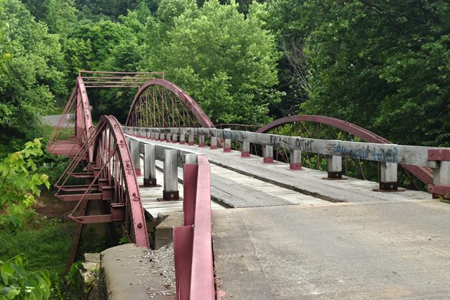
This extremely rare multi-span bowstring truss bridge is one of the oldest bridges of its kind and also sits on rare patented cast iron bents. With its 1869 construction date, it is one of the earliest known King Bridge Company bowstring truss bridges. The bridge sits on rare cast iron bents that were a patented design.

Interpretive Signage Text:
The oldest surviving metal bridge in Indiana. Seated at its end on cut-stone abutments quarried at Grandview, Indiana and erected by Solomon Bridge, Herman Tribbe, and Herman Wilbern. The center spans rest on the only cast-iron piers still in existence in the state and built to the design of Almon B. Ives of Bloomington, Illinois.
Information and Findings From DHPA Historic Bridge SurveyStatement of Significance This 259' bowstring arch structure of one 160', 14-panel through and two 48'6", 5-panel pony spans rests upon stone abutments reinforced with concrete and metal A-frame piers. The spans follow the patented tubular arch of the King Bridge Company. A pair of rectangular die-forged bars extended through the shoe of the arch provide the lower chord. Cylindrical eyebars provide the verticals and the crossed diagonals of each panel are adjusted through the arch. The I floor-beams rest upon the lower chord and are further stabilized by external braces bolted to the arch-chord. The timber deck carries a 16' roadway. The longest of two such throughs extant and the longest bowstring structure in Indiana, this bridge was probably designed by a prolific Ohio firm, four of whose other bowstring ponies still survive in the state. The spans have been rehabilitated and the floor-beams reinforced, although the bridge appears to retain most of its original members, including some latticed guardrail. The consulting engineers who have inspected both counties' bridges also designed the rehabilitation of this "unusual structure." References MW, Inc., Warrick County Bridge Re-Inspection Report (Indianapolis, 1978). Engineer Associates, Inc., Bridge Reinspection Report: Warrick County (Evansville, 1981). United Consulting Engineers, Inc., Bridge Reinspection Report: Warrick County (Indianapolis, 1987). WTH Engineering, Warrick County: Bridge Reinspection Report (Indianapolis, 1999). Associated Engineering Consultants, Inc., Bridge Reinspection Study and Report: Spencer County (Nashville, 1979). Indiana Historic Sites & Structures Inventory, Gibson County and Warrick County: Interim Report (Indianapolis, 1984), 84. Ohio Department of Transportation, Ohio Historic Bridge Inventory Evaluation, and Preservation Plan (Columbus,1983), 36-7. Bridge Considered Historic By Survey: Yes |
![]()
![]()
![]()
Coordinates (Latitude, Longitude):
Search For Additional Bridge Listings:
Bridgehunter.com: View listed bridges within 0.5 miles (0.8 kilometers) of this bridge.
Bridgehunter.com: View listed bridges within 10 miles (16 kilometers) of this bridge.
Additional Maps:
Google Streetview (If Available)
GeoHack (Additional Links and Coordinates)
Apple Maps (Via DuckDuckGo Search)
Apple Maps (Apple devices only)
Android: Open Location In Your Map or GPS App
Flickr Gallery (Find Nearby Photos)
Wikimedia Commons (Find Nearby Photos)
Directions Via Sygic For Android
Directions Via Sygic For iOS and Android Dolphin Browser
USGS National Map (United States Only)
Historical USGS Topo Maps (United States Only)
Historic Aerials (United States Only)
CalTopo Maps (United States Only)

© Copyright 2003-2024, HistoricBridges.org. All Rights Reserved. Disclaimer: HistoricBridges.org is a volunteer group of private citizens. HistoricBridges.org is NOT a government agency, does not represent or work with any governmental agencies, nor is it in any way associated with any government agency or any non-profit organization. While we strive for accuracy in our factual content, HistoricBridges.org offers no guarantee of accuracy. Information is provided "as is" without warranty of any kind, either expressed or implied. Information could include technical inaccuracies or errors of omission. Opinions and commentary are the opinions of the respective HistoricBridges.org member who made them and do not necessarily represent the views of anyone else, including any outside photographers whose images may appear on the page in which the commentary appears. HistoricBridges.org does not bear any responsibility for any consequences resulting from the use of this or any other HistoricBridges.org information. Owners and users of bridges have the responsibility of correctly following all applicable laws, rules, and regulations, regardless of any HistoricBridges.org information.
![]()