

View Information About HSR Ratings
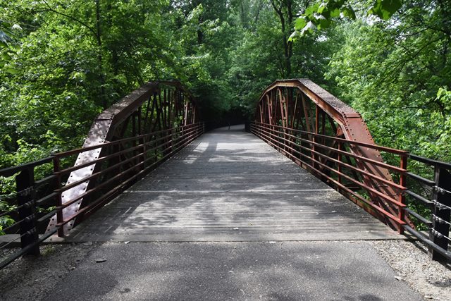
This graceful pony truss bridge was relocated and preserved as a functional attraction on a trail. This bridge previously crossed Cypress Creek on Warner Road (37.948242, -87.336131)

Above: DHPA survey photo showing bridge in previous location.

Above: DHPA survey photo showing bridge in previous location.
Information and Findings From DHPA Historic Bridge SurveyBridge History and Significance The designers of this single-span Warren pony truss used a polygonal top chord. Never parallel with the lower one, the top chord changes slope from one midpanel point to the next. Seated upon concrete abutments and wingwalls, the largely-bolted structure extends 102' in six panels. Its all-interior verticals are manufactured from pairs of angles riveted together with an occasional stay plate which also serves the external sway braces and its diagonals from a pair of angles (somewhat heavier in the outer panels) also riveted together with a few stay plates. The I floor-beams are bolted to the verticals below the lower chord and carry the 16'9" timber deck. This is a quite long example, especially for bolted connections, of an unusual variation of a Warren pony truss. The undecorated whole was fabricated along standard lines for its kind and retains its original integrity. Closed in 2001. References MW, Inc., Warrick County Bridge Re-Inspection Report (Indianapolis, 1978). Engineer Associates, Inc., Bridge Reinspection Report: Warrick County (Evansville, 1981). United Consulting Engineers, Inc., Bridge Reinspection Report: Warrick County (Indianapolis, 1987). WTH Engineering, Warrick County: Bridge Reinspection Report (Indianapolis, 1999). Bridge Considered Historic By Survey: Yes |
![]()
![]()
![]()
Coordinates (Latitude, Longitude):
Search For Additional Bridge Listings:
Bridgehunter.com: View listed bridges within 0.5 miles (0.8 kilometers) of this bridge.
Bridgehunter.com: View listed bridges within 10 miles (16 kilometers) of this bridge.
Additional Maps:
Google Streetview (If Available)
GeoHack (Additional Links and Coordinates)
Apple Maps (Via DuckDuckGo Search)
Apple Maps (Apple devices only)
Android: Open Location In Your Map or GPS App
Flickr Gallery (Find Nearby Photos)
Wikimedia Commons (Find Nearby Photos)
Directions Via Sygic For Android
Directions Via Sygic For iOS and Android Dolphin Browser
USGS National Map (United States Only)
Historical USGS Topo Maps (United States Only)
Historic Aerials (United States Only)
CalTopo Maps (United States Only)

© Copyright 2003-2024, HistoricBridges.org. All Rights Reserved. Disclaimer: HistoricBridges.org is a volunteer group of private citizens. HistoricBridges.org is NOT a government agency, does not represent or work with any governmental agencies, nor is it in any way associated with any government agency or any non-profit organization. While we strive for accuracy in our factual content, HistoricBridges.org offers no guarantee of accuracy. Information is provided "as is" without warranty of any kind, either expressed or implied. Information could include technical inaccuracies or errors of omission. Opinions and commentary are the opinions of the respective HistoricBridges.org member who made them and do not necessarily represent the views of anyone else, including any outside photographers whose images may appear on the page in which the commentary appears. HistoricBridges.org does not bear any responsibility for any consequences resulting from the use of this or any other HistoricBridges.org information. Owners and users of bridges have the responsibility of correctly following all applicable laws, rules, and regulations, regardless of any HistoricBridges.org information.
![]()