

View Information About HSR Ratings
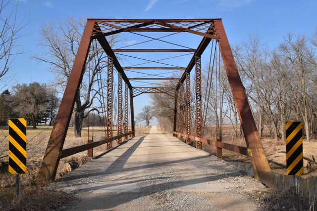
This may the last surviving example of a bridge known to have been built by the Wabash Bridge and Iron Company. This little-known Indiana bridge builder apparently went bankrupt in August 1903.
The bridge has some areas of section loss including the portal bracing and also some substantial section loss on some u-bolt hangers. The bridge has had some insensitive welded plate repairs from a long time ago, and these may be contributing to moisture entrapment, pack rust, and section loss.

Information and Findings From DHPA Historic Bridge SurveyStatement of Significance On orders from the county commissioners in April 1896, Wilmer Gemmer, surveyor-engineer, surveyed seven bridge sites, including for the Big Pine Creek Bridge just north of school house #6 in section 5 of Adams township. Gemmer presented his plan for cut-stone abutments and a through-truss superstructure of 100 ft. span. The board approved Gemmer's plans for all seven structures and set a June letting. The Wabash Bridge and Iron Works succeeded with a package bid of $2,702.42 for all seven superstructures. The substructure contracts were split up among four masons, F. J. Barnhart securing that for the Big Pine Creek Bridge at $1,675.75. Gemmer prescribed and Wabash made a pin-connected, Pratt span with 16-ft. 8-in. truss height and designed to handle 1,400 lbs. per lineal foot of live load and 490 lbs. of dead load. The end- posts and top-chord members were crafted from a pair of 7-in. channels, cover plate, and battens; a pair of die-forged eyebars, somewhat heavier in the center panels, supply the lower-chord members. The verticals which subdivide the trusses into six panels consist of hip hangers--a pair of eyebars (1.5"x.5")--and intermediate ones--a pair of laced 6-in. channels. The pairs of eyebars used for the diagonals also vary a little; the outer ones (2"x5/8") being heavier than the center- panel (1.5"x9/16") ones. Cylindrical rods (1") with turnbuckles counter the diagonals in the two most central panels. A latticed A-frame portal strut, 5-in. I-beam intermediate struts, and 1-in. round rod upper and lower lateral braces support the trusses against sway. The I floor-beams (15") are U-bolted to the lower pins. Lines of 7-in. I-beams run as stringers above the beams and carry the 14-ft. timber deck with 14 feet and 6 inches of vertical clearance. A channel lines each truss as a hub guard. In 1904 the south stone abutment washed away and was replaced by a concrete one by D. A. Dawson for $1,250. The superstructure received a new timber deck and was painted in the late 1920s. A county surveyor-engineer planned this structure, and an important Indiana fabricator built the superstructure. Indeed, this may be the only Wabash Bridge and Iron Pratt through-truss structure to survive in Indiana. The design is nonetheless rather conventional. The original truss members still function, including the latticed portals. The south abutment is an early replacement. Other Information References James C. Kane, Bridge Inspection Report: Warren County (Williamsport, 1974). Indiana State Highway Commission, Inventory of Bridges on State Highway System of Indiana (Indianapolis, 1979). Farrar, Garvey & Associates, Bridge Inspection Report: Warren County (Indianapolis, 1996). Bernardin-Lochmueller & Associates, Bridge Inspection Report: Warren County (Evansville, 2000). H. Stewart Kline & Associates, Inc., Bridge Inspection Report: Fountain County (Lafayette, 1973) Reid, Quebe, et. al., Bridge Inventory & Safety Inspection: Fountain County (Indianapolis, 1979). W. H. Gemmer, "Big Pine Creek Bridge" (1896), "Plan of the Masonry Substructure for the Big Pine Creek Bridge" (1896), "Plan for One Masonry Abutment to Replace One Washed Out at the Pine Creek Bridge" (1904), J. R. Gregory, "Plan for the Repair of Bridge #309 Located over Big Pine Creek," Warren County Highway Department, Bridge #92. Warren County, "Commissioners Record," 15: 78-80, 86; 16: 429. Bridge Considered Historic By Survey: Yes |
![]()
![]()
![]()
Coordinates (Latitude, Longitude):
Search For Additional Bridge Listings:
Bridgehunter.com: View listed bridges within 0.5 miles (0.8 kilometers) of this bridge.
Bridgehunter.com: View listed bridges within 10 miles (16 kilometers) of this bridge.
Additional Maps:
Google Streetview (If Available)
GeoHack (Additional Links and Coordinates)
Apple Maps (Via DuckDuckGo Search)
Apple Maps (Apple devices only)
Android: Open Location In Your Map or GPS App
Flickr Gallery (Find Nearby Photos)
Wikimedia Commons (Find Nearby Photos)
Directions Via Sygic For Android
Directions Via Sygic For iOS and Android Dolphin Browser
USGS National Map (United States Only)
Historical USGS Topo Maps (United States Only)
Historic Aerials (United States Only)
CalTopo Maps (United States Only)

© Copyright 2003-2024, HistoricBridges.org. All Rights Reserved. Disclaimer: HistoricBridges.org is a volunteer group of private citizens. HistoricBridges.org is NOT a government agency, does not represent or work with any governmental agencies, nor is it in any way associated with any government agency or any non-profit organization. While we strive for accuracy in our factual content, HistoricBridges.org offers no guarantee of accuracy. Information is provided "as is" without warranty of any kind, either expressed or implied. Information could include technical inaccuracies or errors of omission. Opinions and commentary are the opinions of the respective HistoricBridges.org member who made them and do not necessarily represent the views of anyone else, including any outside photographers whose images may appear on the page in which the commentary appears. HistoricBridges.org does not bear any responsibility for any consequences resulting from the use of this or any other HistoricBridges.org information. Owners and users of bridges have the responsibility of correctly following all applicable laws, rules, and regulations, regardless of any HistoricBridges.org information.
![]()