

View Information About HSR Ratings
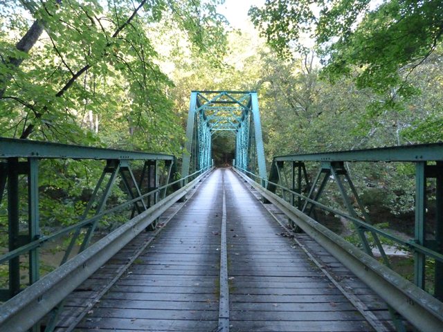
With its 9.5 foot wide roadway, this bridge looks a lot older than it is. In fact, this bridge was constructed in 1937 and its roadway width is more narrow than most bridges built as far back as the 1800s. The reason this bridge is so narrow is that this bridge was originally built as a private bridge for famous inventor Powel Crosley, Jr. who had purchased the land around this bridge for hunting and recreation. Later, his land became public as the Crosley Fish and Wildlife Area when it was purchased by the state in 1958. Along with the purchase came the bridge, which to this day serves the occasional car traveling through the wildlife area. This bridge is historically significant for its association with a famous person and also noteworthy as an example of a privately-built bridge, and offers a comparison to public bridges. The narrower roadway reflects the fact that it was not designed to carry a lot of traffic, and also the narrow width would have reduced construction cost. The bridge is also of interest as a multi-span bridge that offers both a Pratt through and Warren pony truss spans, and as such it displays the two most common truss configurations (Pratt and Warren) and the two most common truss positions (through and pony) all in one bridge.
The bridge was rehabilitated in 1977 and again in 2004.
![]()
![]()
![]()

![]()
![]()
Coordinates (Latitude, Longitude):
Search For Additional Bridge Listings:
Bridgehunter.com: View listed bridges within 0.5 miles (0.8 kilometers) of this bridge.
Bridgehunter.com: View listed bridges within 10 miles (16 kilometers) of this bridge.
Additional Maps:
Google Streetview (If Available)
GeoHack (Additional Links and Coordinates)
Apple Maps (Via DuckDuckGo Search)
Apple Maps (Apple devices only)
Android: Open Location In Your Map or GPS App
Flickr Gallery (Find Nearby Photos)
Wikimedia Commons (Find Nearby Photos)
Directions Via Sygic For Android
Directions Via Sygic For iOS and Android Dolphin Browser
USGS National Map (United States Only)
Historical USGS Topo Maps (United States Only)
Historic Aerials (United States Only)
CalTopo Maps (United States Only)

© Copyright 2003-2024, HistoricBridges.org. All Rights Reserved. Disclaimer: HistoricBridges.org is a volunteer group of private citizens. HistoricBridges.org is NOT a government agency, does not represent or work with any governmental agencies, nor is it in any way associated with any government agency or any non-profit organization. While we strive for accuracy in our factual content, HistoricBridges.org offers no guarantee of accuracy. Information is provided "as is" without warranty of any kind, either expressed or implied. Information could include technical inaccuracies or errors of omission. Opinions and commentary are the opinions of the respective HistoricBridges.org member who made them and do not necessarily represent the views of anyone else, including any outside photographers whose images may appear on the page in which the commentary appears. HistoricBridges.org does not bear any responsibility for any consequences resulting from the use of this or any other HistoricBridges.org information. Owners and users of bridges have the responsibility of correctly following all applicable laws, rules, and regulations, regardless of any HistoricBridges.org information.
![]()