

View Information About HSR Ratings
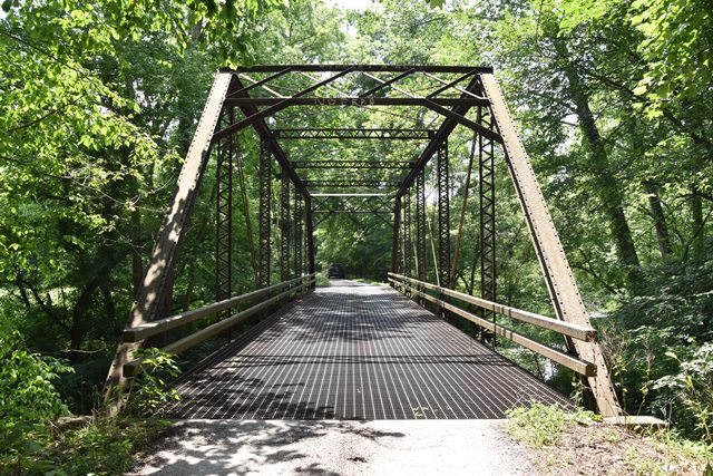
This is one of a unique group of six historic truss bridges found along this road. This is the only through truss among this group. This section of road was a former railroad line, abandoned ca. 1899 and later converted to a highway.
Construction date is an estimate. The bridge is clearly an early 20th century bridge as it displays a transition from pinned to riveted connections, with some connections such as at the hip vertical being a combination of riveted gusset plate and pin.
Information and Findings From DHPA Historic Bridge SurveyBridge History and Significance Seated upon cut stone abutments and wingwalls with concrete caps, this pin-connected Pratt through span extends 106'6" in six panels. A pair of laced channels provides each set of intermediate verticals, a pair of die-forged eyebars serves as the diagonal sets, and single, cylindrical rods with turnbuckles counter the diagonals in the two most central panels. The I floor-beams are bolted to pin plates. The bridge carries a concrete deck with a 15'9" roadway and 14' of vertical clearance. These pinned Pratt through trusses are conventionally designed. The original truss members still function, including the latticed portals. References American Consulting Engineers, Inc., Bridge Inspection/Reinspection Report: Martin County (Indianapolis, 1974, 1979). Bridge Considered Historic By Survey: Yes |
![]()
![]()
![]()
Coordinates (Latitude, Longitude):
Search For Additional Bridge Listings:
Bridgehunter.com: View listed bridges within 0.5 miles (0.8 kilometers) of this bridge.
Bridgehunter.com: View listed bridges within 10 miles (16 kilometers) of this bridge.
Additional Maps:
Google Streetview (If Available)
GeoHack (Additional Links and Coordinates)
Apple Maps (Via DuckDuckGo Search)
Apple Maps (Apple devices only)
Android: Open Location In Your Map or GPS App
Flickr Gallery (Find Nearby Photos)
Wikimedia Commons (Find Nearby Photos)
Directions Via Sygic For Android
Directions Via Sygic For iOS and Android Dolphin Browser
USGS National Map (United States Only)
Historical USGS Topo Maps (United States Only)
Historic Aerials (United States Only)
CalTopo Maps (United States Only)

© Copyright 2003-2024, HistoricBridges.org. All Rights Reserved. Disclaimer: HistoricBridges.org is a volunteer group of private citizens. HistoricBridges.org is NOT a government agency, does not represent or work with any governmental agencies, nor is it in any way associated with any government agency or any non-profit organization. While we strive for accuracy in our factual content, HistoricBridges.org offers no guarantee of accuracy. Information is provided "as is" without warranty of any kind, either expressed or implied. Information could include technical inaccuracies or errors of omission. Opinions and commentary are the opinions of the respective HistoricBridges.org member who made them and do not necessarily represent the views of anyone else, including any outside photographers whose images may appear on the page in which the commentary appears. HistoricBridges.org does not bear any responsibility for any consequences resulting from the use of this or any other HistoricBridges.org information. Owners and users of bridges have the responsibility of correctly following all applicable laws, rules, and regulations, regardless of any HistoricBridges.org information.
![]()