

View Information About HSR Ratings
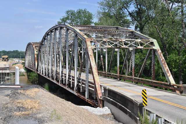
This two span state standard through truss bridge is finding new life as two separate bridges preserved in a park setting, on a trail in Eagle Park and Brown County State Park near Nashville, Indiana.
Photo of one of the spans from Google Maps: https://goo.gl/maps/DbjzTKmB93pcPZ7H7
Information and Findings From DHPA Historic Bridge SurveyDiscussion of Truss Bridge The ISHC decided to bypass the Bowling Green covered bridge with a steel structure in 1934. The crossing of the Eel River was long established in the neighborhood, being the location for the busiest ferry in the county for half a century. A timber wagon bridge tenuously spanned the river at Bowling Green from 1852-53 until 1858. Rarick and Black built a two-span covered timber- truss structure in 1870. The Vincennes Bridge Company of Vincennes, Indiana, won the contract to build the state's two- span steel structure with a bid in January 1934 of $63,058.13, about seven thousand dollars below the state engineers' estimates. Vincennes completed the structure by the spring of 1935. The ISHC relied on a slightly-revised third-generation standard plan (#479A) for its 198-ft., riveted, Parker through-trusses with 24-ft. roadways. The state ordered the structure erected upon its typical concrete abutments and pier but--atypically--on a 398-ft vertical curve. Truss depth varied from 21 ft. 6 in. at the portal to 33 ft. at midspan. Each truss carried eleven 18-ft. panels bounded by verticals made of a pair of laced 10-in. channels (@15.3#, except for the second from the end @20#). To protect the quite-tall trusses against wind and vehicle-induced stress, the verticals are buttressed with substantial latticed struts and heavy upper sway framing above the 15 ft. of roadway clearance. The portals used latticed sections. The diagonals combined angles with battens into heavier members in the outer panels than toward center: in the outermost, two pairs of angles (4"x3.5"Ls); in the second and third, a pair (7"x4"Ls); in the fourth, a pair (3.5"x3"Ls). A pair of angles (4"x3.5"Ls) and battens provide counters in the three most central panels. Each of the top chord's members is differently sloped; only the central panel's is parallel with the lower chord; and all were fabricated from a pair of 15-in. channels getting heavier toward midspan (from 35-50#). Two pairs of angles--all of the same size (6"x4"Ls)--riveted together with battens and buttressed in all but the two most outer panels with plates provide the lower chord's members. The ISHC used 33-in. I floor-beams (@141#) riveted to the verticals above the lower chord. Eight rows of heavier rolled I stringers (16"@40#) are attached to the floor-beams' sides. Together, the floor-beams and the stringers carry the concrete deck. A pair of angles supplies each lower sway bracing member. Latticed hand rails originally lined the inner sides of all the trusses, and coped concrete rails with bush-hammered panels marked the approaches. The crossing of the Eel River at Bowling Green by ferry and bridge has been active and started early. The latest bridge is a multi-span example of an important, revised, third-generation ISHC standard plan additionally significant for the structure's vertical curve. While the trusses retain their original members, the guard rails have replaced. The coped concrete approach rails with bush-hammered panels do remain. A major Indiana fabricator-builder erected this structure. References Clay County, "Commissioners Record," 27: 42, 152. George E. Gould, Indiana Covered Bridges Thru the Years (1977), 30. William Travis, History of Clay County (Chicago, 1909), I: 67-68, 78. Inventory of Bridges on State Highway System of Indiana (Indianapolis, 1989). Indiana State Highway Commission, Structure #46-C-1316; Contract #684; Superstructure Standard #479A. Discussion of Previous Covered Bridge "...The first bridge over Eel River was put up on the site of the present one, at Bowling Green, in 1852 or 1853, by William K. Houston, Bowling Green, contractor. This bridge was not substantially built, no stone abutments having been put under it, and in 1857 was pronounced unsafe. In 1857 ...Jacob Gilbrech was given the contract for repairing it...in the summer of 1858, the bridge was condemned and its further use abandoned...in 1868, the present bridge at Bowling Green was built by Rarick and Black at a cost of $12,000...." John Tressel was paid $20 for repairing the Eel River Bridge near Bowling Green in November 1900. In October 1914, the county commissioners adopted specifications for a new and corrugated metal, galvanized roof for the Bowling Green Bridge. A month later, the board contracted with O. V. Miller for $374 for reroofing the bridge. In April 1915, Sheehan presented specifications for bridge estimated repairs of $500 for repair including wooden members at contact points with the abutments, plus selecting repointing of stone in the abutments and pier. In August 1928, the commissioners sought, without success, bids for the repair of the Eel River bridge at Bowling Green. The county hired John Wyatt of Cory to paint the roof and repair all leaks in the roof of the Bowling Green covered bridge in June 1930. The proposed removal of the bridge led to citizen protest that the commissioners took under consideration in November 1935. For the replacement structure, see State Highway Bridge #1316. References Clay County, "Commissioners Record," 18: 248; 27: 42, 45, 56; 32: 688; 33: 334; 34: 415. Charles Blanchard, editor, Counties of Clay and Owen, Indiana (Chicago, F.A. Battey & Co., 1884), 54. William Travis, History of Clay County, Indiana (Chicago, 1909), 67-68, 78, 152. Bridge Considered Historic By Survey: Yes |
![]()
![]()
![]()
This historic bridge has been relocated and is no longer at this location. See the main bridge page for a link to the new bridge location. This map is shown for reference purposes only.
Coordinates (Latitude, Longitude):
Search For Additional Bridge Listings:
Bridgehunter.com: View listed bridges within 0.5 miles (0.8 kilometers) of this bridge.
Bridgehunter.com: View listed bridges within 10 miles (16 kilometers) of this bridge.
Additional Maps:
Google Streetview (If Available)
GeoHack (Additional Links and Coordinates)
Apple Maps (Via DuckDuckGo Search)
Apple Maps (Apple devices only)
Android: Open Location In Your Map or GPS App
Flickr Gallery (Find Nearby Photos)
Wikimedia Commons (Find Nearby Photos)
Directions Via Sygic For Android
Directions Via Sygic For iOS and Android Dolphin Browser
USGS National Map (United States Only)
Historical USGS Topo Maps (United States Only)
Historic Aerials (United States Only)
CalTopo Maps (United States Only)

© Copyright 2003-2024, HistoricBridges.org. All Rights Reserved. Disclaimer: HistoricBridges.org is a volunteer group of private citizens. HistoricBridges.org is NOT a government agency, does not represent or work with any governmental agencies, nor is it in any way associated with any government agency or any non-profit organization. While we strive for accuracy in our factual content, HistoricBridges.org offers no guarantee of accuracy. Information is provided "as is" without warranty of any kind, either expressed or implied. Information could include technical inaccuracies or errors of omission. Opinions and commentary are the opinions of the respective HistoricBridges.org member who made them and do not necessarily represent the views of anyone else, including any outside photographers whose images may appear on the page in which the commentary appears. HistoricBridges.org does not bear any responsibility for any consequences resulting from the use of this or any other HistoricBridges.org information. Owners and users of bridges have the responsibility of correctly following all applicable laws, rules, and regulations, regardless of any HistoricBridges.org information.
![]()