

View Information About HSR Ratings
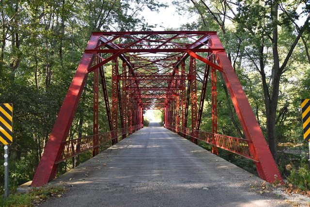
This riveted Parker truss bridge has a number of features that make it stand out in Indiana.
Information and Findings From DHPA Historic Bridge SurveyBridge History and Significance Seated upon its concrete abutments and wingwalls, this hybrid all-riveted through Parker spans almost 200'. Separated into ten panels by intermediate verticals of laced heavy channels, the truss consists of a two-panel center section (with the top chord parallel to the bottom one and crossed diagonals within the panels), a two-panel side section (with crossed diagonals in the panel adjacent to the center section), and a single panel section next to the inclined endpost. All diagonals are angles riveted to stay plates; most are installed from top to bottom panel points towards midspan. I floor-beams riveted to gussets and vertical plates below the lower chord support the bituminous-over-timber deck with a 16'8" roadway and 17' of vertical clearance. County Line Bridge (Hancock County Bridge #105) crosses the Big Blue River in the southeastern portion of the county and services the north-south road that is the line between Hancock and Rush County lines. The bridge is still used by vehicular traffic and is currently the object of a rehabilitation project, still in the planning phases, undertaken by the Hancock County Commissioners. The bridge is a 200' Parker through truss with a clearance of 15'5" and is considered a single lane bridge because its width is four inches short of the state's minimum required eighteen feet. The bridge is a good candidate for rehabilitation. The trusses are comprised of ten panels, each twenty feet wide. The top chords of the bridge are made of iron I-beams and have seven different slopes. The first slope of the chord is the inclined endpost and changes slope at the second panel. The slope changes again at the third panel, but remains constant through the fourth. The fifth and sixth panels also share the same slope, which is parallel to the bottom chord, and the top chord then descends in the same order as it rises. The bottom chord of the truss is comprised of four pieces of angle iron, riveted together to form an "H" channel. The verticals in the trusses are made from pairs of I-beams that are connected diagonally by iron straps. This changes between the first and second, and corresponding ninth and tenth, panels where the verticals are made of two pieces of angle stock attached with shorter iron straps. The diagonals in the trusses are made in the same way as these particular verticals. The outer diagonals, for panels 2, 3, 8, and 9, stand alone, whereas the middle four panels have two diagonals that cross. The verticals and diagonals are connected to the bottom chord by large iron gusset plates, that also serve as the connection points for the floor-beams to the chord. The top chords are connected by panels where the horizontal struts are made from two lengths of angle stock connected by diagonal iron lacing, and individual lengths that cross for the diagonals. The 17'8" wide deck is comprised of 3.5" square timbers that are directly supported by six I-beam and two "C" channel stringers that run the length of the bridge. The deck, at some point, has been asphalted over. The stringers are supported by nine large I-floor-beams that are connected to the trusses by the gusset plates. The guardrails for the bridge are latticework-connected angle stock that are bolted to angles that are riveted to the I-beam verticals. The bridge is seated into large concrete abutments that are suported by wood pilings. The bridge is in good condition, but the engineer's analysis noted a problem with general rust along the stringers. The same rust problem has been noted about the floor-beams, but the connections to the gusset plates have remained clean. A large amount of dirt and debris has accumulated in the members of the bottom chord, due to their arrangement. The general alignment of the bridge has remained satisfactory, even with the weakened lateral bracing. The bearing seats for the trusses are in good condition. The report filed by the engineer was used in consideration of the rehabilitation of the bridge. One of five extant structures of this Parker hybrid style, the truss retains its original members including its decoratively latticed portal and guardrails. This bridge is National Register-eligible for several reasons: the structure is connected with a prolific Indiana manufacturer; it has an unusual length, and the particularities of the design, especially the pattern of polygonation of the top chord and the complete reliance upon riveting at such an early date, are significant. Also, the almost complete replacement of metal truss bridges in Hancock County adds to the importance of this bridge. County Line Bridge (Hancock County Bridge #105) is eligible for inclusion to the National Register under Criterion C for its engineering . The bridge is extremely significant as the longest still surviving Parker through truss bridge built before the First World War in Indiana. It is also locally important as the only example of its type found in Hancock County. The bridge is also representative of the advances made in the bridge construction industry around the turn of the century with its notable lack of I-beams, replaced with angle stock, much of which was manipulated and riveted in the field. The north-south county line road, separating Hancock and Rush Counties, notably absent from the 1876 atlas of the state of Indiana, was a significant road, nonetheless, due to the fact that the bridge servicing it previous to 1916 was constructed of iron which required a large investment indeed. During the flooding of January 1916, the bridge, which was deteriorated by some accounts, was washed out. The loss of the bridge concerned the Rush County Commissioners more than their counterparts in neighboring Hancock County. When asked for a joint meeting of the two groups, the Hancock Commissioners elected to have the session two months later in April. In the interim, the Rush County fathers had the county engineer, Adolphus Cameron, draw up plans and specifications for the new bridge, and the group also allocated $15,000 for its construction. When the two commissions finally met, the Hancock commissioners quickly agreed to accept their directives. After bids were gathered, the firm chosen to build the new bridge was the Burk Construction Company of New Castle, Indiana. The Burks' bid of $11,000 was the lowest and they agreed to have the bridge completed by Oct. 1 of that same year. The actual designer of the bridge is still a bit of conjecture. Adolphus Cameron did draw up the preliminary plans, and with a degree in Civil Engineering from Purdue University, he was probably able to come up with a fairly specific design. The Burks', having the Pan-American Bridge Company as their home-base fabricator, had a good designer, Warren Converse, working iwth them. It is probably the case that both Cameron and Converse's knowledge and talent were combined to design this large, complicated bridge. The County Line Bridge is an example of a Parker through truss--the only one found in Hancock County, and one of less that thirty that still survive in Indiana. The Parker truss is essentially a modified Pratt truss. The Pratt truss is noted for its vertical components acting in compression and the diagonals in tension, and the Parker truss has the same features, but the top chord is polygonal rather than straight. James L. Cooper, author of the comprehensive survey Iron Monuments to Distant Posterity: Indiana's Metal Bridges, 1870-1930, noted, in a separate history of this particular bridge, a few unusual design elements. The width of the panels, at twenty feet, is just eight inches short of the longest panel width of all of Indiana's extant pre-1930 Parker through trusses. At the same time, the top chord of the bridge, at the middle two panels, is parallel to the bottom chord which is a feature more normally associated with the five slope chord of the Camelback bridge. It is Cooper's history that also brings to light the important advances in bridge construction. The foremost of these is the lack of I-beams in the design of the bridge. The majority of these components are found in the deck of the bridge, and the only truss I-beams are found in the top chords and verticals. The rest of the truss, including all bracing and webbing, are made of various sizes of angle and flat stock. At the same time, the trusses of this bridge were too long to have been completely constructed at the shop and then transported to the site. Therefore, the entire length of the trusses must have been field-riveted. As Cooper notes, "...while field-riveting was not unusual by 1916, riveting connections for trusses as long and heavy as these on the site was still a tricky business for highway bridge erectors (6)." While the sheer length of this bridge added to its age makes it a remarkable example of excellent engineering, the additional advances in bridge fabrication it represents clearly denotes a need for recognition. In November of 1993, the Hancock County Commissioners voted to rehabilitate this important bridge. References Barker, James. "Inspection Report: Hancock County Bridge #105," 1993. Cooper, James L. "County Line Bridge over the Big Blue River (Hancock County Bridge #105)," 1993. _______. Iron Monuments to Distant Posterity: Indiana's Metal Bridges, 1870-1930. Indianapolis: Pierson Printing, 1987. Hancock County Engineering Dept. Structure Inventory and Appraisal Sheets (Greenfield, 1974). Indiana Historic Sites & Structures Inventory. Hancock County: Interim Report (Indianapolis, 1983). SIECO, Inc. Bridge Reinspection Report: Hancock County (Columbus, 1979). Bridge Considered Historic By Survey: Yes |
![]()
![]()
![]()
Coordinates (Latitude, Longitude):
Search For Additional Bridge Listings:
Bridgehunter.com: View listed bridges within 0.5 miles (0.8 kilometers) of this bridge.
Bridgehunter.com: View listed bridges within 10 miles (16 kilometers) of this bridge.
Additional Maps:
Google Streetview (If Available)
GeoHack (Additional Links and Coordinates)
Apple Maps (Via DuckDuckGo Search)
Apple Maps (Apple devices only)
Android: Open Location In Your Map or GPS App
Flickr Gallery (Find Nearby Photos)
Wikimedia Commons (Find Nearby Photos)
Directions Via Sygic For Android
Directions Via Sygic For iOS and Android Dolphin Browser
USGS National Map (United States Only)
Historical USGS Topo Maps (United States Only)
Historic Aerials (United States Only)
CalTopo Maps (United States Only)

© Copyright 2003-2024, HistoricBridges.org. All Rights Reserved. Disclaimer: HistoricBridges.org is a volunteer group of private citizens. HistoricBridges.org is NOT a government agency, does not represent or work with any governmental agencies, nor is it in any way associated with any government agency or any non-profit organization. While we strive for accuracy in our factual content, HistoricBridges.org offers no guarantee of accuracy. Information is provided "as is" without warranty of any kind, either expressed or implied. Information could include technical inaccuracies or errors of omission. Opinions and commentary are the opinions of the respective HistoricBridges.org member who made them and do not necessarily represent the views of anyone else, including any outside photographers whose images may appear on the page in which the commentary appears. HistoricBridges.org does not bear any responsibility for any consequences resulting from the use of this or any other HistoricBridges.org information. Owners and users of bridges have the responsibility of correctly following all applicable laws, rules, and regulations, regardless of any HistoricBridges.org information.
![]()