

View Information About HSR Ratings
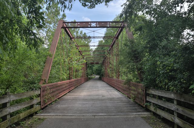
Relocated and preserved, this is a rare surviving bridge built by the Lomas Forge and Bridge Works and has some unusual details. The bridge was moved off of its previous location in 1999 and installed here in 2003. The previous location was in Warren County, Indiana, over Big Pine Creek on CR 125 E (40.31742, -87.29165).
Information and Findings From DHPA Historic Bridge SurveyBridge History and Significance Common Springs Road provided one of the overland routes between Attica and the coal fields around Carbondale since the mid-nineteenth century. At Harris' farm, Big Pine Creek was forded until June 1887, when the Warren county commissioners decided to have an iron bridge raised on cut-stone abutments. The board first ordered Stinas Barnhart to prepare specifications for the approaches and the stone work "without pay." Once, within ten days, Barnhart produced an acceptable set of specifications, the board set a letting date in August. On the 11th, Fox and Carter secured the contract for the approaches, and Antin Ellgin won the county's nod to build the stone abutments. With arrangements made for the substructure, the board turned to the superstructure, advertising for proposals accompanied with plans and drawings of a combination or iron bridge of 150 ft. In early September, the Lomas Forge and Bridge Works of Cincinnati, Ohio, proffered the winning bid of $18.50 per lineal foot of superstructure. The county made its final payments to Fox and Carter for the approaches and to Ellgin for the stonework in early November. Lomas finished the superstructure, including the timber deck which Samuel Clark provided. Lomas Forge designed a pin-connected, Pratt through-truss span of 150 ft. subdivided into nine panels. The end-posts and top-chord members consist of crafted channels, cover plate, and battens riveted together; the lower chord of a pair of die-forged eyebars. Round-rod hangers serve as the hip verticals; laced channels provide the intermediate verticals. For diagonals, Lomas relied on a pair of die-forged eyebars except in the central panel where the diagonal doubled as a counter. Cylindrical rod with turnbuckles work as counter-braces in the five central panels. The trusses are stiffened against moving loads with a latticed portal strut and laced intermediate ones plus round-rod lateral bracing above and below. U-bolted to the lower pins, rectangular girder floor-beams support the I-beam stringers which ride above and in turn carry the 15-ft. timber roadway with 17 feet of vertical clearance. Latticed guardrails line the trusses. The structure on this long-established county road is significant in its own right. It may be the only extant Pratt through-truss structure which the predecessor of the Brackett Bridge Company, a prolific Ohio firm, designed and fabricated and raised on a cut-stone substructure built by local masons. The structure retains its original members, including its decoratively latticed portals and guardrails and pierced sheet nameplates. Restored and relocated to Clear Creek Trail, Bloomington, Monroe County, for pedestrian use. (See listing therefor.) References James C. Kane, Bridge Inspection Report: Warren County (Williamsport, 1974). Indiana State Highway Commission, Inventory of Bridges on State Highway System of Indiana (Indianapolis, 1979). Farrar, Garvey & Associates, Bridge Inspection Report: Warren County (Indianapolis, 1996). Bernardin-Lochmueller & Associates, Bridge Inspection Report: Warren County (Evansville, 2000). bridge nameplate(s). Warren County, "Commissioners Record," 12: 274, 276, 284, 287, 310-311, 314-317, 357. Bridge Considered Historic By Survey: Yes |
![]()
![]()
![]()
Coordinates (Latitude, Longitude):
Search For Additional Bridge Listings:
Bridgehunter.com: View listed bridges within 0.5 miles (0.8 kilometers) of this bridge.
Bridgehunter.com: View listed bridges within 10 miles (16 kilometers) of this bridge.
Additional Maps:
Google Streetview (If Available)
GeoHack (Additional Links and Coordinates)
Apple Maps (Via DuckDuckGo Search)
Apple Maps (Apple devices only)
Android: Open Location In Your Map or GPS App
Flickr Gallery (Find Nearby Photos)
Wikimedia Commons (Find Nearby Photos)
Directions Via Sygic For Android
Directions Via Sygic For iOS and Android Dolphin Browser
USGS National Map (United States Only)
Historical USGS Topo Maps (United States Only)
Historic Aerials (United States Only)
CalTopo Maps (United States Only)

© Copyright 2003-2024, HistoricBridges.org. All Rights Reserved. Disclaimer: HistoricBridges.org is a volunteer group of private citizens. HistoricBridges.org is NOT a government agency, does not represent or work with any governmental agencies, nor is it in any way associated with any government agency or any non-profit organization. While we strive for accuracy in our factual content, HistoricBridges.org offers no guarantee of accuracy. Information is provided "as is" without warranty of any kind, either expressed or implied. Information could include technical inaccuracies or errors of omission. Opinions and commentary are the opinions of the respective HistoricBridges.org member who made them and do not necessarily represent the views of anyone else, including any outside photographers whose images may appear on the page in which the commentary appears. HistoricBridges.org does not bear any responsibility for any consequences resulting from the use of this or any other HistoricBridges.org information. Owners and users of bridges have the responsibility of correctly following all applicable laws, rules, and regulations, regardless of any HistoricBridges.org information.
![]()