

View Information About HSR Ratings
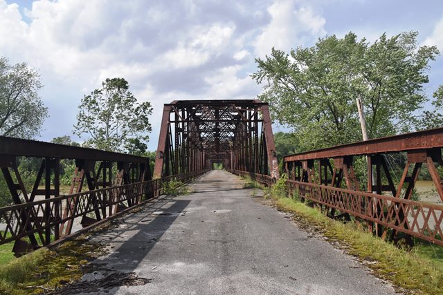
This large combination through and pony truss was abandoned as a newer US-41 bridge exists to the west. This bridge is notable for its size. There are four through truss spans and four pony truss spans, and the rest are concrete.
Information and Findings From DHPA Historic Bridge SurveyBridge History and Significance Although the Commissioners of Knox and Gibson Counties advertised their intent to build a bridge here as early as 1913, the current structure was designed by the State Highway Department and contracted to the Stein Construction Company of Milwaukee, Wisconsin, for $238, 767. The twenty-nine spans cover 2,003' upon a concrete substructure and connect with 5,000' of approach embankment. NORTH SPANS: Twenty-one 41' spans of six concrete beams each adjoin the embankment from the north, and are followed by two 84' all-riveted Warren pony spans of seven panels each. Diagonals and verticals are fabricated from heavy angles riveted to stay plates. I floor-beams, riveted to gussets above the lower chord, carry the concrete deck and its 20'4" roadway. SOUTH SPANS: South of the twenty-three approaches come four all-riveted Parker through trusses which cross the river in 198' spans of eleven panels each. Intermediate verticals of tightly laced channels bound most panels; the top chord angle is varied for each. Heavy angles (decreasing in size toward midspan) are riveted to stay plates and serve as all the diagonals. Most are angled inward from the top to the bottom panel point; the three central panels also use cross diagonals as counters. Although girder floor-beams are riveted to gussets above the lower chord, the through trusses still allow 14'9" of vertical clearance. Two Warren pony spans, similar to those north of the Parkers, complete the structure on the south. Pictured in the Engineering News in 1924 and presented as "one of the longest highway structures in the Middle West," this was one of Indiana's most advertised bridges. It is tied for the longest remaining Parker structure in the state and is among the longest overall. The structure appears to retain its original members, including its decoratively latticed guardrails. Not included in 1996 BIR. References United Construction and Engineering Corporation, Bridge Inspection Study and Report: Knox County (Indianapolis, 1972). Associated Engineering Consultants, Bridge Reinspection Study and Report: Knox County (Nashville, 1977, 1981). United Consulting Engineers & Architects, Bridge Inventory Report: Knox County (Indianapolis, 2002). Lowell E. Morrison, Bridge Inspection Survey and Report of Gibson County (Princeton, 1974, 3 vols.). United Consulting Engineers, Inc., Bridge Reinspection Report for Gibson County (Indianapolis, 1980, 2 vols.). Engineering News, LXIX, (16 Jan. 1913), Construction News, 34; LXXXVIII, (23 Mar. 1922), Construction News, 127; LXXXVIII, (11 May 1922), Construction News, 232; LXXXXII, (3 Jan. 1924), 19. Bridge Considered Historic By Survey: Yes |
![]()
![]()
![]()
Coordinates (Latitude, Longitude):
Search For Additional Bridge Listings:
Bridgehunter.com: View listed bridges within 0.5 miles (0.8 kilometers) of this bridge.
Bridgehunter.com: View listed bridges within 10 miles (16 kilometers) of this bridge.
Additional Maps:
Google Streetview (If Available)
GeoHack (Additional Links and Coordinates)
Apple Maps (Via DuckDuckGo Search)
Apple Maps (Apple devices only)
Android: Open Location In Your Map or GPS App
Flickr Gallery (Find Nearby Photos)
Wikimedia Commons (Find Nearby Photos)
Directions Via Sygic For Android
Directions Via Sygic For iOS and Android Dolphin Browser
USGS National Map (United States Only)
Historical USGS Topo Maps (United States Only)
Historic Aerials (United States Only)
CalTopo Maps (United States Only)

© Copyright 2003-2024, HistoricBridges.org. All Rights Reserved. Disclaimer: HistoricBridges.org is a volunteer group of private citizens. HistoricBridges.org is NOT a government agency, does not represent or work with any governmental agencies, nor is it in any way associated with any government agency or any non-profit organization. While we strive for accuracy in our factual content, HistoricBridges.org offers no guarantee of accuracy. Information is provided "as is" without warranty of any kind, either expressed or implied. Information could include technical inaccuracies or errors of omission. Opinions and commentary are the opinions of the respective HistoricBridges.org member who made them and do not necessarily represent the views of anyone else, including any outside photographers whose images may appear on the page in which the commentary appears. HistoricBridges.org does not bear any responsibility for any consequences resulting from the use of this or any other HistoricBridges.org information. Owners and users of bridges have the responsibility of correctly following all applicable laws, rules, and regulations, regardless of any HistoricBridges.org information.
![]()