

View Information About HSR Ratings
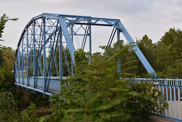
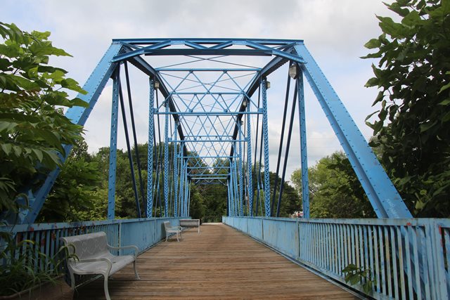
This relocated and preserved historic bridge is noted for its early use of bolted connections and its lightweight Parker truss design. The bridge originally crossed Coal Creek on CR-1000 South (Hibbs Road) in Fountain County, Indiana (39.980934, -87.386348). The bridge has vertical members composed of two angles with v-lacing arranged in an unusual manner such that only half of the lacing bar is visible on each side. This design of built-up beam is uncommon.

Above: Historical photo showing bridge in its previous location.

Above: Historical photo showing bridge in its previous location.
Information and Findings From DHPA Historic Bridge SurveyPrevious Structure on Original Site (1887-1903) The Fountain county commissioners decided in September of 1887 to bridge Coal Creek at William Hibbs' land in Fulton township. They contracted with Stanis Bernhart at $6.45 per cubic yard of stone to erect two masonry abutments and with the Massillon Bridge Company for a combination Warren-truss superstructure for $3,000. For some years now, the county had relied upon Bernhart for cut-stone substructures and on Massillon for "combination bridges," that is, for bridges of iron and timber. The precise nature of the Hibbs Bridge superstructure remains unknown. But, with the abutments spaced almost 150-feet apart, the superstructure must have consisted of through trusses. Original Site (1903-2003) The "Commissioners Record" reveals little of the life-story of the Massillon trusses at the Hibbs crossing of Coal Creek. In April of 1903, however, the board received bids for a replacement structure, and the home-county Attica Bridge Company came in with the lowest and therefore the best bid at $2,989. The contract probably included the construction of the concrete caps on Bernhart's original stone abutments. This could have provided for more level bearing points for the new superstructure as well as for raising it higher above the creek. Each panel-length segment of the top chord to mid-span of the largely-bolted Parker trusses were set at a different angle. A pair of laced channels riveted to small gussets above and below provided each vertical. A pair of angles served as diagonals in each panel and were counter-braced in the four most central panels with a pair of adjustable round bars. Laced and braced angles made up the portal struts. Sway frames of laced angles, attached though the cover plate of the top chord and to the vertical, braced the upper areas of the trusses. Adjustable rods provided the lower laterals. Bolted to gussets below the lower chord, rolled I floor-beams carried the timber deck with its 13-ft. and 5-in. roadway and 16 feet and 4 inches of vertical clearance. Latticed railings lined the trusses. The roadway through the Hibbs property in Fulton township and the crossing of Coal Creek there was established enough to be noted in the 1876 atlas of Indiana and important enough to merit a combination bridge in 1887. The existing superstructure is at least the second at this site. Stanis Bernhart, who built most of the stone abutments for the county in his era, laid the substructure for the first iron structure across Coal Creek at Hibbs place in 1887 and was reused for the second metal-truss span as well. The Hibbs Bridge superstructure is noteworthy in its own right. It is far more than a decade older than either of the other two bolted Parker through-truss spans extant in Indiana as of 1990 and the only one designed and fabricated by the Attica Bridge Company, a significant Fountain County firm in its day. The bridge retained its original members, including decoratively latticed guardrails. Relocation Site The bolted Parker trusses were dismantled in 2003 for repair and relocation as part of a pedestrian crossing of the White River in Anderson. References H. Stewart Kline & Associates, Inc., Bridge Inspection Report: Fountain County (Lafayette, 1973). Reid, Quebe, et al., Bridge Inventory & Safety Inspection: Fountain County (Indianapolis, 1979). Beam, Longest & Neff, Fountain County: Bridge Inventory Rating and Safety Inspection (Indianapolis, 2002). Baskin, Forster & Co., Illustrated Historical Atlas of Indiana (Indiana Historical Society, 1968 reprint of 1876 ed.). "Bridge Bids, Attica Ledger, 12 August 1886: p3c4. Fountain County, "Commissioners Record," 11: 397, 434-437, 446, 560-561; 12: 23-27; References H. Stewart Kline & Associates, Inc., Bridge Inspection Report: Fountain County (Lafayette, 1973). Reid, Quebe, et al., Bridge Inventory & Safety Inspection: Fountain County (Indianapolis, 1979). Beam, Longest & Neff, Fountain County: Bridge Inventory Rating and Safety Inspection (Indianapolis, 2002). Baskin, Forster & Co., Illustrated Historical Atlas of Indiana (Indiana Historical Society, 1968 reprint of 1876 ed.). "Bridge Bids, Attica Ledger, 12 August 1886: p3c4. Fountain County, "Commissioners Record," 11: 397, 434-437, 446, 560-561; 12: 23-27; Bridge Considered Historic By Survey: Yes |
This bridge is tagged with the following special condition(s): Unorganized Photos
![]()
![]()
![]()
![]()
![]()
Coordinates (Latitude, Longitude):
Search For Additional Bridge Listings:
Bridgehunter.com: View listed bridges within 0.5 miles (0.8 kilometers) of this bridge.
Bridgehunter.com: View listed bridges within 10 miles (16 kilometers) of this bridge.
Additional Maps:
Google Streetview (If Available)
GeoHack (Additional Links and Coordinates)
Apple Maps (Via DuckDuckGo Search)
Apple Maps (Apple devices only)
Android: Open Location In Your Map or GPS App
Flickr Gallery (Find Nearby Photos)
Wikimedia Commons (Find Nearby Photos)
Directions Via Sygic For Android
Directions Via Sygic For iOS and Android Dolphin Browser
USGS National Map (United States Only)
Historical USGS Topo Maps (United States Only)
Historic Aerials (United States Only)
CalTopo Maps (United States Only)

© Copyright 2003-2024, HistoricBridges.org. All Rights Reserved. Disclaimer: HistoricBridges.org is a volunteer group of private citizens. HistoricBridges.org is NOT a government agency, does not represent or work with any governmental agencies, nor is it in any way associated with any government agency or any non-profit organization. While we strive for accuracy in our factual content, HistoricBridges.org offers no guarantee of accuracy. Information is provided "as is" without warranty of any kind, either expressed or implied. Information could include technical inaccuracies or errors of omission. Opinions and commentary are the opinions of the respective HistoricBridges.org member who made them and do not necessarily represent the views of anyone else, including any outside photographers whose images may appear on the page in which the commentary appears. HistoricBridges.org does not bear any responsibility for any consequences resulting from the use of this or any other HistoricBridges.org information. Owners and users of bridges have the responsibility of correctly following all applicable laws, rules, and regulations, regardless of any HistoricBridges.org information.
![]()