

View Information About HSR Ratings
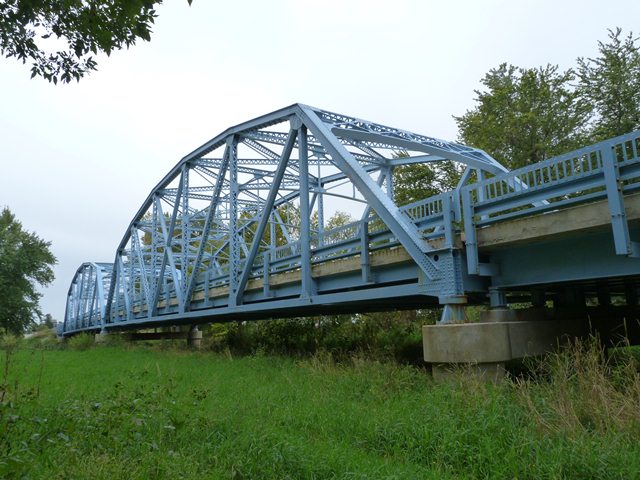
This bridge is an impressive example of one of Indiana's state standard plan truss bridges. Indiana had a few different varieties of standard plans they employed for truss bridge construction. This bridge displays what is perhaps the most attractive of their designs, since it features portal and sway bracing that has a pleasing arched shape to it. This bridge is noted for its multi-span configuration, with two truss spans and a steel stringer span at each end. The bridge appears to retain good integrity. An exception is that one vertical member has been replaced, and it was replaced with a different, more modern design of built-up beam so it tends to stick out visually.

Information and Findings From DHPA Historic Bridge SurveyStatement of Significance This bridge represents the IDH's revised standard and additionally-braced design for 150' Parkers with wide decks. The arching of the lower chords is quite unusual. The structure appears to retain its original members, including the metal guardrails. Architectural Description The Indiana Department of Highways significantly modified its standard 150' Parker through-truss design in the late 1930s to accommodate roadways wider than 25'. The revised design reduced the number of panels,
relied more heavily upon rolled I beams in the webbing and lower chord members, and stiffened the portal bracing. Other Information In June 1941, the Gradle Brothers of Indianapolis, Indiana, secured a contract for $91,717.71 to build a four-span, state design bridge. The new structure replaced a 140-ft. covered timber truss span of Burr Arch
design which carried a 15-ft. roadway and was seated on cut-stone abutments. The Gradle Brothers completed the new bridge, which consisted of a 51-ft. 6-in. I-beam approach at each end flanking a pair of Parker through-truss spans
all seated on concrete piers and abutments, by the end of 1941. The ISHC used a fourth-generation standard plan for their 150-ft., riveted, Parker spans with 26- ft. roadways bordered by 1-ft. 6-in. curbs or walks. Standard #1522
appears to have essentially followed the earlier #1531 in all except the deck. Truss depth varied from 22 ft. at the portal to 29 ft. 8 in. at midspan. Each truss carried seven panels, the outer two at each end of 20 ft. and the
inner three at 23 ft. 4 in. All top chord members are differently sloped, and only the central panel's is parallel with the lower chord. All were fabricated from a pair of 12-in. channels, the endposts at 35 lbs. and the others at
30 lbs. The lower chord's members consist of 10-in. rolled I- beams growing in weight from the ends (@54#) towards midspan (@77#). Most of the verticals were made of a pair of latticed 10-in. channels (@15.3#); the hip vertical of a
10-in. I-beam (@33#). To protect the quite-tall trusses against wind and vehicle-induced stress, substantial latticed struts and heavy upper sway framing buttressed the verticals above the 15 ft. of roadway clearance. The portals
also relied on latticed sections. Even as they shifted between sections, the diagonals grew lighter toward midspan: in the second panel, a 10-in. rolled I-beam (@41#); in the third, a pair of 10-in. channels (@15.3#); in the fourth,
a rolled 10-in. I-beam (21#). The ISHC required 36-in. I floor-beams, growing heavier toward midspan (150#>182#) and riveted to the verticals above the lower chord. Ten rows of 18-in. rolled I-beam stringers, also growing heavier
toward midspan (47#>50#), were attached to the floor-beams' sides. Together, the floor-beams and the stringers carry the concrete deck with 15 feet of vertical clearance. Tube-and-post guardrails lined the trusses. Bridge Considered Historic By Survey: Yes |
![]()
![]()
![]()

![]()
![]()
Coordinates (Latitude, Longitude):
Search For Additional Bridge Listings:
Bridgehunter.com: View listed bridges within 0.5 miles (0.8 kilometers) of this bridge.
Bridgehunter.com: View listed bridges within 10 miles (16 kilometers) of this bridge.
Additional Maps:
Google Streetview (If Available)
GeoHack (Additional Links and Coordinates)
Apple Maps (Via DuckDuckGo Search)
Apple Maps (Apple devices only)
Android: Open Location In Your Map or GPS App
Flickr Gallery (Find Nearby Photos)
Wikimedia Commons (Find Nearby Photos)
Directions Via Sygic For Android
Directions Via Sygic For iOS and Android Dolphin Browser
USGS National Map (United States Only)
Historical USGS Topo Maps (United States Only)
Historic Aerials (United States Only)
CalTopo Maps (United States Only)

© Copyright 2003-2024, HistoricBridges.org. All Rights Reserved. Disclaimer: HistoricBridges.org is a volunteer group of private citizens. HistoricBridges.org is NOT a government agency, does not represent or work with any governmental agencies, nor is it in any way associated with any government agency or any non-profit organization. While we strive for accuracy in our factual content, HistoricBridges.org offers no guarantee of accuracy. Information is provided "as is" without warranty of any kind, either expressed or implied. Information could include technical inaccuracies or errors of omission. Opinions and commentary are the opinions of the respective HistoricBridges.org member who made them and do not necessarily represent the views of anyone else, including any outside photographers whose images may appear on the page in which the commentary appears. HistoricBridges.org does not bear any responsibility for any consequences resulting from the use of this or any other HistoricBridges.org information. Owners and users of bridges have the responsibility of correctly following all applicable laws, rules, and regulations, regardless of any HistoricBridges.org information.
![]()