

View Information About HSR Ratings
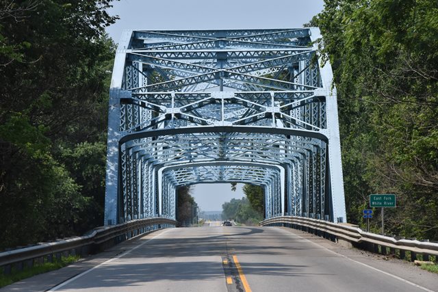
This is an outstanding example of Indiana's beautiful state standard truss featuring arched bracing .
Information and Findings From DHPA Historic Bridge SurveyBridge History and Significance R. P. Olinger of Huntingburg, Indiana, secured a $72,698.59 contract in July 1940 to build a two-span structure with one of the ISHC's longest Parker through-truss designs upon concrete abutments and pier. The new bridge was completed by early summer 1941. instead of modifying its standard design for 198-foot Parkers to accommodate decks wider than twenty-three feet, the ISHC developed a new 200-foot model in 1939. In comparison with the old standand, the new one used nine instead of eleven panels, thus increasing panel width from eighteen feet to twenty-two feet and three inches, and turned to heavier members. The state relied on standard plan #1521 for this twenty-six-foot roadway sandwiched between a pair of two-feet walks. Truss depth varied from 24 ft. at the portal to 39 ft. at midspan. Panel width varied, too. The outer two on each end are twenty feet and 7.5-inches wide and the inner five are twenty-three feet and six inches. Every top chord member is differently sloped; only the central panel's one is parallel with the lower chord; and all were fabricated from a pair of 15-in. channels (@45# for the endposts, third, fourth, and fifth panels, and @40# for the second). For the lower chord, a pair of 15-in. channels riveted together with battens grow in weight from the outer panels (@40#) to the inner- most one (@55#). The state used rolled I-beams in a few web members. The verticals or posts consist of two forms and weights: the hip vertical is a 10-in. I-beam (@33#); the others are made from a pair of laced 10-in. channels (@15.3#). To protect the quite-tall trusses against wind and vehicle-induced stress, substantial latticed struts and heavy upper sway framing buttress the verticals above 15 ft. of roadway clearance. The portals used latticed sections, too. While a 10-in. I-beam (@41#) provided the second-panel diagonal, the third used a pair of laced 10-in. channels (@20#), the fourth a pair of 12-in. channels (@23.7#), and the fifth a 10-in. I-beam (@21#). Only the central panel was countered. The ISHC prescribed 30-in. I floor-beams increasing in weight toward midspan (@172#>200#) riveted to the verticals above the lower chord. Eight rows of rolled I-beam stringers attached to the floor-beams' sides varied in depth and weight by placement. The 20-ft. panels used 16-in. Is at 36 lbs. for the outside and 18-in. ones at 55 lbs. for the central ones. The 23-ft. 6-in. panels relied on 16-in. outer Is at 37 lbs and 21-in. Is at 29 lbs for the inner ones. Together, the floor-beams and the stringers carry the concrete deck with 15 feet of vertical clearance. Angles supply each lower sway-bracing member. Tube-channel-and-post rails lined the inner sides of the trusses, and coped concrete approach rails with bush-hammered panels funneled traffic into the spans. This bridge is one of the oldest surviving examples of the state's longest standard trussed span. Except for replacing the North portal on one span, the trusses retain their original members. While the metal guardrails remain, the concrete approaches have been replaced. With a major rehabilitation of the deck came a number of other changes: some stringers replaced, walks removed and roadway widened, new deck of metal grid and concrete introduced. References Indiana State Highway Commission, Structure #31-E-1677; Contract #1997; Superstructure Standard #1521. Indiana Historic Sites & Structures Inventory, Jackson County: Interim Report (Indianapolis, 1988), 2-4. Bridge Considered Historic By Survey: Yes |
![]()
![]()
![]()
Coordinates (Latitude, Longitude):
Search For Additional Bridge Listings:
Bridgehunter.com: View listed bridges within 0.5 miles (0.8 kilometers) of this bridge.
Bridgehunter.com: View listed bridges within 10 miles (16 kilometers) of this bridge.
Additional Maps:
Google Streetview (If Available)
GeoHack (Additional Links and Coordinates)
Apple Maps (Via DuckDuckGo Search)
Apple Maps (Apple devices only)
Android: Open Location In Your Map or GPS App
Flickr Gallery (Find Nearby Photos)
Wikimedia Commons (Find Nearby Photos)
Directions Via Sygic For Android
Directions Via Sygic For iOS and Android Dolphin Browser
USGS National Map (United States Only)
Historical USGS Topo Maps (United States Only)
Historic Aerials (United States Only)
CalTopo Maps (United States Only)

© Copyright 2003-2024, HistoricBridges.org. All Rights Reserved. Disclaimer: HistoricBridges.org is a volunteer group of private citizens. HistoricBridges.org is NOT a government agency, does not represent or work with any governmental agencies, nor is it in any way associated with any government agency or any non-profit organization. While we strive for accuracy in our factual content, HistoricBridges.org offers no guarantee of accuracy. Information is provided "as is" without warranty of any kind, either expressed or implied. Information could include technical inaccuracies or errors of omission. Opinions and commentary are the opinions of the respective HistoricBridges.org member who made them and do not necessarily represent the views of anyone else, including any outside photographers whose images may appear on the page in which the commentary appears. HistoricBridges.org does not bear any responsibility for any consequences resulting from the use of this or any other HistoricBridges.org information. Owners and users of bridges have the responsibility of correctly following all applicable laws, rules, and regulations, regardless of any HistoricBridges.org information.
![]()