

View Information About HSR Ratings
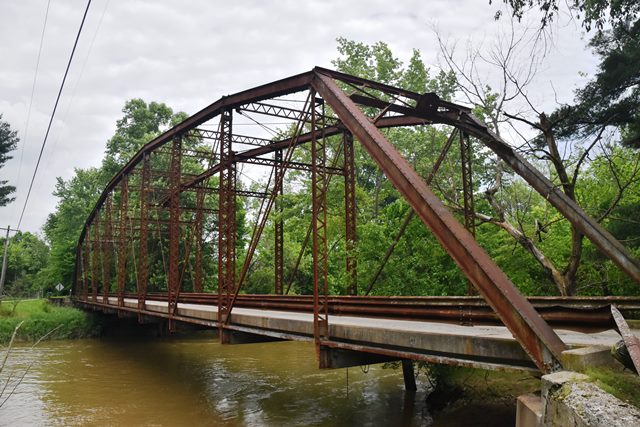
Built by a prolific in-state builder, this bridge helps document the variety of designs the company built. The bridge is a very late example of a pin-connected truss.
Information and Findings From DHPA Historic Bridge SurveyBridge History and Significance The Vincennes Bridge Company of Vincennes, Indiana, erected this single-span, pin-connected Parker variant upon concrete abutments and wingwalls and under the watchful eye of Lou Drescher, County Engineer. Serving as the intermediate verticals, laced channels divide the 200' structure into ten panels comprising one central and two side sections of two panels each and a single-panel section ahead of the inclined endpost. Except for the cylindrical eyebars with turnbuckles which serve as counters from the top central pin, all diagonals are double die-forged eyebars fitted twoards midspan from the top to the bottom pin in each panel. Heavy I floor-beams are bolted to the pin-plates below the lower chord. They support the concrete deck which carries a 15'2" roadway and 18' of vertical clearance. As the five extant Parker trusses constructed by this prolific Indiana firm reveal, Vincennes Bridge varied its patterns. This bridge represents a variant which appears to have been used for some fairly long spans. Although lacking in decorative elements, the truss retains its original members. References Beam, Longest & Neff, Inc., Owen County Bridge Inventory Rating & Safety Inspection (Indianapolis, 1973). Associated Engineering Consultants, Inc., Bridge Reinspection Study & Report: Owen County (Nashville, 1978). bridge nameplate. Bridge Considered Historic By Survey: Yes (Select) |
![]()
![]()
![]()
Coordinates (Latitude, Longitude):
Search For Additional Bridge Listings:
Bridgehunter.com: View listed bridges within 0.5 miles (0.8 kilometers) of this bridge.
Bridgehunter.com: View listed bridges within 10 miles (16 kilometers) of this bridge.
Additional Maps:
Google Streetview (If Available)
GeoHack (Additional Links and Coordinates)
Apple Maps (Via DuckDuckGo Search)
Apple Maps (Apple devices only)
Android: Open Location In Your Map or GPS App
Flickr Gallery (Find Nearby Photos)
Wikimedia Commons (Find Nearby Photos)
Directions Via Sygic For Android
Directions Via Sygic For iOS and Android Dolphin Browser
USGS National Map (United States Only)
Historical USGS Topo Maps (United States Only)
Historic Aerials (United States Only)
CalTopo Maps (United States Only)

© Copyright 2003-2024, HistoricBridges.org. All Rights Reserved. Disclaimer: HistoricBridges.org is a volunteer group of private citizens. HistoricBridges.org is NOT a government agency, does not represent or work with any governmental agencies, nor is it in any way associated with any government agency or any non-profit organization. While we strive for accuracy in our factual content, HistoricBridges.org offers no guarantee of accuracy. Information is provided "as is" without warranty of any kind, either expressed or implied. Information could include technical inaccuracies or errors of omission. Opinions and commentary are the opinions of the respective HistoricBridges.org member who made them and do not necessarily represent the views of anyone else, including any outside photographers whose images may appear on the page in which the commentary appears. HistoricBridges.org does not bear any responsibility for any consequences resulting from the use of this or any other HistoricBridges.org information. Owners and users of bridges have the responsibility of correctly following all applicable laws, rules, and regulations, regardless of any HistoricBridges.org information.
![]()