

View Information About HSR Ratings
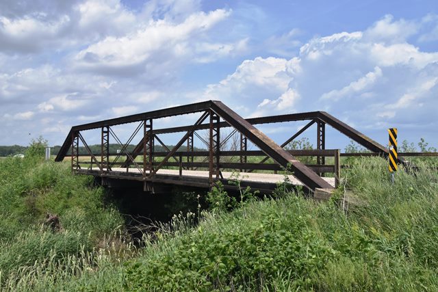
This is a fairly heavy and extremely late example of a pin-connected pony truss bridge. So late in fact that normally HistoricBridges.org would dismiss a 1923 construction date for a pin-connected truss. However, Vincennes Bridge Company was one of only a couple companies that actually does appear to have built pin connected trusses into the 1920s, although it is unclear why.
Information and Findings From DHPA Historic Bridge SurveyBridge History and Significance In the early 1880s, E. B. Martindale of Indianapolis came to Greene County for duck shooting in its swamps. Soon he speculated on the 4,000 acres of four-mile marsh and promoted their drainage through steam-driven dredging. Out of his investment came a handsome and exceedingly fertile farm serviced by roads on lands once four to six feet under water. A number of these roads needed to be bridged over the deep and wide ditches that made Martindale his fortune. In September 1893, George M. Notter was paid $123.45 and $136.40 "for repairing the abutment" on a bridge over Four-Mile Ditch on the Lyons and Bloomfield Gravel Road. In 1923, the commissioners planned to build four structures over Four-mile ditch. The county council, however, appropriated money for only two, including the structure south of Switz City near the Martindale farm. The county's appointed engineer, L. H. Parker, estimated the cost of this bridge at $4,660. The Vincennes Bridge Company bid $8,484 total for the two. The pin-connected, full-hip Pratt pony-truss span rests upon concrete abutments and wingwalls. The 86-ft. structure is subdivided into five panels by verticals made from pairs of laced angles with pin plates riveted to the backs of the angles at top and bottom. A pair of channels with a cover plate riveted above and battens below supplies the top chord. Lower chord and outer diagonal members consist of a pair of die-forged eyebars. Pairs of cylindrical rods with turnbuckles provide the center panel's diagonals and counters. Rolled I floor-beams, riveted to angles which are in turn bolted to pin plates, carry the steel stringers and concrete deck with its 15-ft. 8-in. roadway. A pair of channels with occasional angle posts line the trusses and extend to the ends of the endposts. The Vincennes Bridge Company used a rather old-fashioned but nonetheless quite functional general design for a bridge to service the farm of a man who revolutionized the county's agriculture. The bridge retains all its original and unadorned members. SELECT status. References Butler, Fairman & Seufert, Inc. Bridge Inspection Report: Greene County (Indianapolis, 1974). M.W., Inc. Bridge Reinspection Report: Greene County (Indianapolis, 1978). United Consulting Engineers, Inc. Bridge Reinspection Report: Greene County (Indianapolis, 1981). "A Lesson in Drainage," The Bloomfield Democrat, 2 February 1894: 1. Greene County, "Commissioners Record," Q: 146, 155; "Commissioners Docket," 17: 159-161, 166. Bridge Considered Historic By Survey: Yes (Select) |
![]()
![]()
![]()
Coordinates (Latitude, Longitude):
Search For Additional Bridge Listings:
Bridgehunter.com: View listed bridges within 0.5 miles (0.8 kilometers) of this bridge.
Bridgehunter.com: View listed bridges within 10 miles (16 kilometers) of this bridge.
Additional Maps:
Google Streetview (If Available)
GeoHack (Additional Links and Coordinates)
Apple Maps (Via DuckDuckGo Search)
Apple Maps (Apple devices only)
Android: Open Location In Your Map or GPS App
Flickr Gallery (Find Nearby Photos)
Wikimedia Commons (Find Nearby Photos)
Directions Via Sygic For Android
Directions Via Sygic For iOS and Android Dolphin Browser
USGS National Map (United States Only)
Historical USGS Topo Maps (United States Only)
Historic Aerials (United States Only)
CalTopo Maps (United States Only)

© Copyright 2003-2024, HistoricBridges.org. All Rights Reserved. Disclaimer: HistoricBridges.org is a volunteer group of private citizens. HistoricBridges.org is NOT a government agency, does not represent or work with any governmental agencies, nor is it in any way associated with any government agency or any non-profit organization. While we strive for accuracy in our factual content, HistoricBridges.org offers no guarantee of accuracy. Information is provided "as is" without warranty of any kind, either expressed or implied. Information could include technical inaccuracies or errors of omission. Opinions and commentary are the opinions of the respective HistoricBridges.org member who made them and do not necessarily represent the views of anyone else, including any outside photographers whose images may appear on the page in which the commentary appears. HistoricBridges.org does not bear any responsibility for any consequences resulting from the use of this or any other HistoricBridges.org information. Owners and users of bridges have the responsibility of correctly following all applicable laws, rules, and regulations, regardless of any HistoricBridges.org information.
![]()