

View Information About HSR Ratings
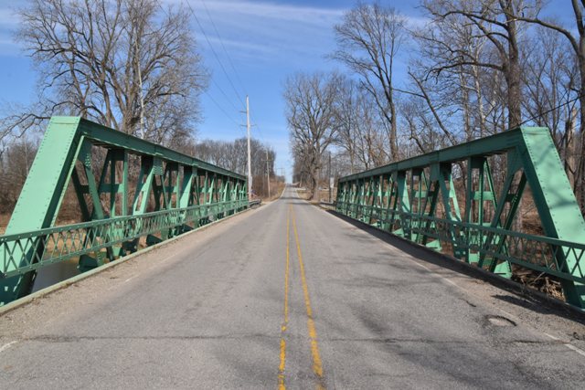
First relocated here in 1968, this excellent example of standard riveted pony truss in Indiana was rehabilitated in 2007.
Information and Findings From DHPA Historic Bridge SurveyStatement of Significance Previous Structure (1913-1932) The Attica Bridge Company made the superstructure for the John Replogee Bridge in 1913 for $3,270; Charles T. Minnix erected the concrete substructure; and Jesse A. Smith built the approaches. Current Structure - (1932-1968/69) By the end of 1927, the old bridge stood in need of considerable repair. The Carroll County commissioners discussed and demurred. On came the Great Depression and then the Second World War. Indeed, not until about 1968 did the county take decisive action--when offered the opportunity to purchase a used state-design bridge from nearby Howard County. The county erected a concrete substructure to accommodate the state span. In July 1931, Albert B. Hash of Sandborn, Indiana, secured a contract from the ISHC for $20,679.90 to build the state's design on SR #22 over Wildcat Creek less than a half-mile west of Greentown. Hash's bid came in at more than $7,000 below the state engineers' estimate for the construction of this very long, half-hip Warren pony-truss span with a 24-ft. roadway on concrete abutments and wingwalls. The structure had been completed by the spring of 1932. The ISHC developed a standard plan for this 112-ft. span, one that it used only on this single occasion. Standard #466 required about 75 tons of structural steel. The 12-ft. deep trusses carry seven 16-ft. panels, all of whose members are riveted together. The trusses were shop-assembled in three sections and then "spliced" or field-riveted together on site at the time of erection. The external sway braces are well integrated through shared battens with the all-interior verticals-- each of two pairs of angles (3.5"x2.5"Ls) riveted together. Pairs of different sizes of angles-- heavier towards the ends (6"x4"Ls) than towards midspan (5"x3"Ls)--riveted together with battens also supply the interior diagonals. The hip diagonals consist of two pairs of angles (3.5"x3"Ls) also connected with battens. The lower chord members consist of a single pair of channels (10"x15.3#s) in the end panels. The pair of channels in the other panels is doubled with the weight growing towards midspan (from 10"x15.3# coupled with x20#s outer to 10"x30#s at center). Heavy 33"x132# I floor-beams are riveted to the verticals above the lower chord, and nine rows of 14"x33# I stringers are attached to the floor beam sides to carry the concrete deck. The lower lateral sway bracing was doubled under the central panel. Latticed guardrails provide some modest protection for the trusses. In 1968 the state highway department replaced the Warren pony-truss span with three spans of prestressed concrete box beams carrying a deck nearly twice as wide as the steel trusses had provided. The structurally-sound trusses were dismantled, moved to Carroll County, and bolted back together atop a new substructure. This structure may well represent the longest Warren pony-truss span ever designed and built by the ISHC. It appears to retain all its original members reconfigured in their prescribed places. Even the deck width remains as originally planned. While the substructure and the deck are new and bolts have replaced some original rivets, the retention of the original lattice guardrail may be a more potent symbol of how much has been kept. Other Information References Charles J. Ritzler, Bridge Inspection Report: Carroll County (Delphi, 1974-75). Rumschlag Technical Services, Carroll County Bridge Inventory & Appraisal Report (Brownsburg, 2006). Indiana State Highway Commission, Structure, #22-H-231; Contract, #427; Superstructure Standard, #466. Carroll County, "Commissioners Record," 24: 258; 28: 177, 211. "Notice to Contractors," "Commissioners Court," Carroll Co. Citizen Times, 5, 12 April 1913: p5c3, p5c4. Bridge Considered Historic By Survey: Yes |
![]()
![]()
![]()
Coordinates (Latitude, Longitude):
Search For Additional Bridge Listings:
Bridgehunter.com: View listed bridges within 0.5 miles (0.8 kilometers) of this bridge.
Bridgehunter.com: View listed bridges within 10 miles (16 kilometers) of this bridge.
Additional Maps:
Google Streetview (If Available)
GeoHack (Additional Links and Coordinates)
Apple Maps (Via DuckDuckGo Search)
Apple Maps (Apple devices only)
Android: Open Location In Your Map or GPS App
Flickr Gallery (Find Nearby Photos)
Wikimedia Commons (Find Nearby Photos)
Directions Via Sygic For Android
Directions Via Sygic For iOS and Android Dolphin Browser
USGS National Map (United States Only)
Historical USGS Topo Maps (United States Only)
Historic Aerials (United States Only)
CalTopo Maps (United States Only)

© Copyright 2003-2024, HistoricBridges.org. All Rights Reserved. Disclaimer: HistoricBridges.org is a volunteer group of private citizens. HistoricBridges.org is NOT a government agency, does not represent or work with any governmental agencies, nor is it in any way associated with any government agency or any non-profit organization. While we strive for accuracy in our factual content, HistoricBridges.org offers no guarantee of accuracy. Information is provided "as is" without warranty of any kind, either expressed or implied. Information could include technical inaccuracies or errors of omission. Opinions and commentary are the opinions of the respective HistoricBridges.org member who made them and do not necessarily represent the views of anyone else, including any outside photographers whose images may appear on the page in which the commentary appears. HistoricBridges.org does not bear any responsibility for any consequences resulting from the use of this or any other HistoricBridges.org information. Owners and users of bridges have the responsibility of correctly following all applicable laws, rules, and regulations, regardless of any HistoricBridges.org information.
![]()