

View Information About HSR Ratings
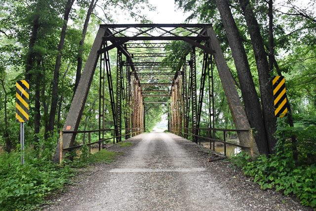
This notable Camelback through truss bridge sits on a road that floods sometimes. The road south of this bridge was flooded when the bridge was photo-documented. The construction date given is an estimate.
Information and Findings From DHPA Historic Bridge SurveyBridge History and Significance The Prior Miller Bridge When Gibson and Pike built the first Miller Bridge over the Patoka on the county line remains undetermined. An agreement with the Pittsburgh Bridge Company with payment in June 1891 ( Pike: $579.95; Gibson: $1,495.05) could well have signalled construction of a metal-truss structure here. In June and July of 1904, the two counties employed the Indiana Bridge Company of Muncie to draw up plans for repair of Miller Bridge. The IBCo secured a $1,265 contract for the job (Gibson county paying 60%; Pike 40%). The repairs included new joists in five panels and the construction of a 14-foot approach span with a 14-foot roadway. The Current Miller Bridge The dimensions and form of the old bridge do not jibe with those of the current structure, so the as yet unanswered question is not if but when and how replacement took place. The Patoka River was dredged through Pike county as Houchins Ditch in the early 1920s, often requiring lengthened or additional bridge structures over the natural or ditched sections of the river. The Pike county commissioners did signal their willingness to build a new Miller Bridge on the county line in April 1924, but the records read to date do not show a response from the Gibson board or denote any contracting. That the existing structure is bolted together leaves open the possibility that the span was moved from county road converted into a state highway in the 1920s. A state highway survey does show the existing span at its current location in 1936. Structural Description Seated atop concrete abutments and wingwalls, this camelback through truss looks like a second generation design of the Vincennes Bridge Company. Bolted rather than pin-connected, the structure's lower chord and diagonal members rely on angles riveted to each other with stay plates rather than on eyebars. Laced channel verticals divide the span into nine panels in a standard manner: the center section consists of three panels with crossing diagonals: each side section has two panels with diagonals angled inward from the top chord connection toward a more central, lower-chord gusset. I floor-beams are bolted to gussets below the lower chord. They carry runs of steel stringers which, in turn, support the concrete deck with 16 feet of vertical clearance. One of a handful of extant camelbacks with bolted connections, this structure appears to retain its original members. References Lowell E. Morrison, Bridge Inspection Survey and Report of Gibson County (Princeton, 1974). Ohio Valley Engineers, Bridge Inspection Survey and Report: Pike County (Evansville, 1974, 1984). United Consulting Engineers, Inc., Bridge Reinspection Report for Gibson County (Indianapolis, 1980); Bridge Reinspection Report for Pike County (Indianapolis, 1980). Indiana Bridge Company, contract #5440, "Contract Index," (Archives & Drawings, School of Architecture, Ball State University). Indiana State Highway Commission, "Bridge Survey," 970: 20. Gibson County, "Commissioners Record," S:417. Pike County, "Commissioners Record," P: 61; S: 85, 117, 119; Y: 70. Bridge Considered Historic By Survey: Yes |
![]()
![]()
![]()
Coordinates (Latitude, Longitude):
Search For Additional Bridge Listings:
Bridgehunter.com: View listed bridges within 0.5 miles (0.8 kilometers) of this bridge.
Bridgehunter.com: View listed bridges within 10 miles (16 kilometers) of this bridge.
Additional Maps:
Google Streetview (If Available)
GeoHack (Additional Links and Coordinates)
Apple Maps (Via DuckDuckGo Search)
Apple Maps (Apple devices only)
Android: Open Location In Your Map or GPS App
Flickr Gallery (Find Nearby Photos)
Wikimedia Commons (Find Nearby Photos)
Directions Via Sygic For Android
Directions Via Sygic For iOS and Android Dolphin Browser
USGS National Map (United States Only)
Historical USGS Topo Maps (United States Only)
Historic Aerials (United States Only)
CalTopo Maps (United States Only)

© Copyright 2003-2024, HistoricBridges.org. All Rights Reserved. Disclaimer: HistoricBridges.org is a volunteer group of private citizens. HistoricBridges.org is NOT a government agency, does not represent or work with any governmental agencies, nor is it in any way associated with any government agency or any non-profit organization. While we strive for accuracy in our factual content, HistoricBridges.org offers no guarantee of accuracy. Information is provided "as is" without warranty of any kind, either expressed or implied. Information could include technical inaccuracies or errors of omission. Opinions and commentary are the opinions of the respective HistoricBridges.org member who made them and do not necessarily represent the views of anyone else, including any outside photographers whose images may appear on the page in which the commentary appears. HistoricBridges.org does not bear any responsibility for any consequences resulting from the use of this or any other HistoricBridges.org information. Owners and users of bridges have the responsibility of correctly following all applicable laws, rules, and regulations, regardless of any HistoricBridges.org information.
![]()