HistoricBridges.org Menu: HistoricBridges.org Menu:


We Recommend:
Bach Steel - Experts at historic truss bridge restoration.

HistoricBridges.org: Bridge Browser

New Harmony Bridge

Harmony Way Bridge

New Harmony Bridge

Primary Photographer(s): Nathan Holth

Bridge Documented: November 2, 2013

View Photos
and Videos
View Maps
and Links

Facility Carried / Feature Intersected
IN-66 and IL-14 Over Wabash River
Location
New Harmony: Posey County, Indiana and White County, Illinois: United States
Structure Type
Metal 10 Panel Rivet-Connected Parker Through Truss, Fixed and Approach Spans: Metal 7 Panel Rivet-Connected Warren Deck Truss, Fixed
Construction Date and Builder / Engineer
1930 By Builder/Contractor: Nashville Bridge Company of Nashville, Tennessee
Rehabilitation Date
1962
Main Span Length
300.0 Feet (91.4 Meters)
Structure Length
2,579.0 Feet (786.1 Meters)
Roadway Width
20 Feet (6.1 Meters)
Spans
4 Main Span(s) and 34 Approach Span(s)
Inventory Number
23305

Historic Significance Rating (HSR)
View Information About HSR Ratings

Bridge Documentation

This bridge's future is at risk!

Bridge Status: This historic bridge is at risk for demolition!

View Archived National Bridge Inventory Report - Has Additional Details and Evaluation

View The National Register of Historic Places Nomination Form For This Historic Bridge

View Selected Original Plan Sheets For This Historic Bridge

View A Timeline For This Bridge

View A Historical Dedication Pamphlet

Note: Special thanks are due to Dr. James L. Cooper for his extensive research on this bridge the results of which were kindly made available to HistoricBridges.org. Most of the information, history, and materials relating to this bridge are thanks to his research efforts. Be sure to view the National Register Nomination Form for this bridge, linked above, for a detailed discussion of the bridge.

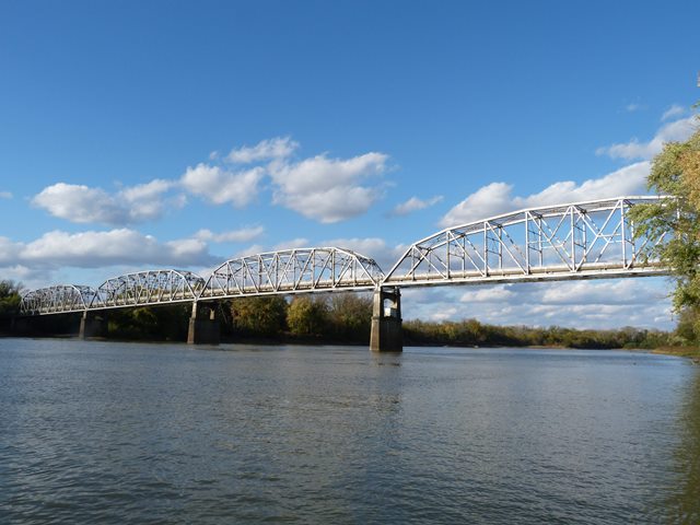
This bridge is a large bridge that includes a variety of span types. The long approach system at each end consists of steel stringer spans supported by steel bents. There are also two deck truss approach spans, one of 60 foot and one of 100 feet at the eastern approach. The main spans of the bridge are four rivet-connected Parker through truss spans. The western three Parker truss spans range from 232-234 feet in length, while the eastern Parker truss span is quite a bit longer with its 300 foot span. The bridge is a state line bridge. In the context of Indiana, the Parker truss spans are the largest of their kind in the state.

The bridge has an uncommon ownership history, as it was built under the direction of the Harmony Way Bridge Company. Ownership and operation of a bridge by a bridge company was common for large bridges in the 1800s, but was much less common by the time this bridge was built. Even more unusual, the bridge continued to be operated as a toll bridge, later taken over by a bridge commission. Toll bridges in the present day are usually associated with enormous bridges or bridges on busy freeways. A toll bridge for a small town carrying a two-lane road is somewhat uncommon.

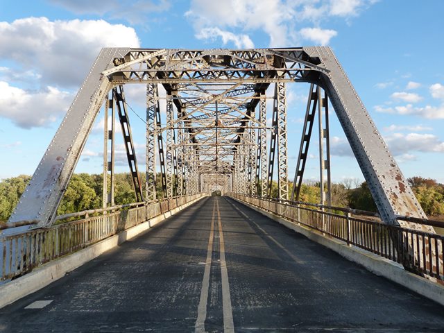
The truss spans of this bridge enjoy excellent historic integrity with no major alterations. Many of the approach stringer spans are also unaltered. However, a number of the approach spans were replaced by the Army Corps of Engineers with cantilevered steel stringer spans and new concrete piers with the intent of addressing problems with the river and original bents near the river.

In 2012, the bridge was closed when an inspection report noted significant deterioration. It is worth noting that the original bridge material is in general in fair condition. The highly deteriorated sections of the bridge are the non-original spans put in by the Army Corps.

The future of this bridge is uncertain. Many locals are supportive of restoring and reopening the bridge, however demolition of the bridge is on the table for consideration as well.

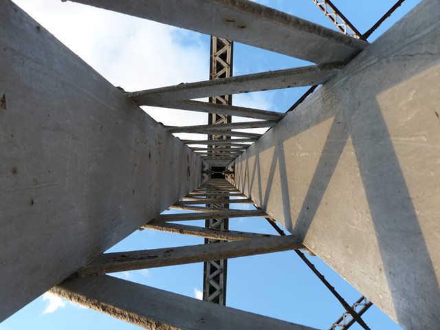
HistoricBridges.org is proud to feature an extremely extensive photo-documentation of this bridge. As the bridge was closed to traffic, it allowed for an unusually extensive ease of access to get photos from every angle.

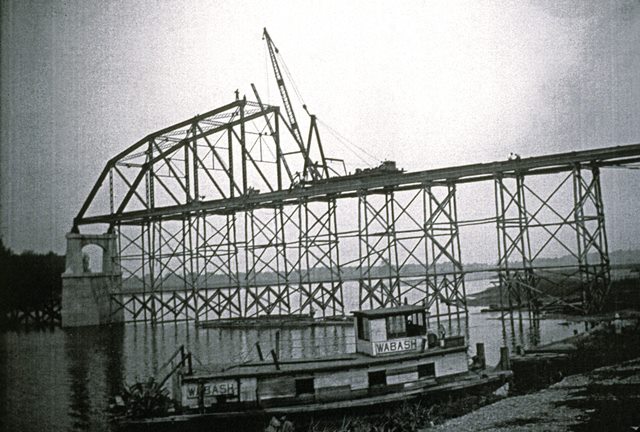
Information and Findings From DHPA Historic Bridge Survey

Statement of Significance

A number of features make this structure noteworthy. The crossing is long-standing, the toll feature atypical for Indiana, and the fabricator unusual here. The design also has some special features. The pattern for sloping the Parkers' top chords and the counterbalancing-struts of the center panels are quite unusual. Deck trusses are not common in Indiana either, and again the counter diagonals of the center panel in the longest Warren is different. The bridge appears to retain all its original members, including guardrails.

Architectural Description

To replace the traditional ferry crossing of the Wabash River at New Harmony, Indiana, the Harmony Way Bridge Company proposed the construction of a toll bridge probably in the early 1920s when a considerable number of toll structures for across the Ohio and Wabash were being discussed in river communities. By March 1929 Congress had granted a franchise for the Harmony Way Bridge, the War Department approved plans, and construction was scheduled for summer 1930. The Nashville Bridge Company of Nashville, Tennessee, fabricated the steel spans, metal piers, and pier towers or bents for the 2,579-ft. structure. By September 1939, the Harmony Way Bridge Company offered to sell their bridge to the state of Indiana, and within a year the Indiana State Toll Bridge Commission had agreed to purchase the structure for $945,000. Apparently the agreement with the state of Indiana was never completed, since the White County Illinois Bridge Commission now owns and maintains the structure.

The steel superstructures sit on high concrete piers for crossing the river and on steel piers alternated with pier-towers mounted on concrete bases for the approaches. Ten I-beam spans provide a 340-ft. approach to the river from New Harmony on a 5% grade. One 80-ft. 9-in. girder span plus thirty I-beam spans extend 1,000 ft. on a 3.5% grade westward from the river into Illinois.

All of the six trussed spans are riveted. Two Warren deck-truss spans with verticals complete the eastern approach, and four Parker through-truss spans cross the river. The Warrens consist of a four-panel span at 60 ft. and a seven-panel one at 100 ft. Laced channels provide the top-chord members and a pair of angles and battens the lower ones. The endpost and inner verticals are crafted from four laced angles; the four angles of the outer ones are riveted together with battens. The diagonals consist of a pair of angles--lighter toward midspan--and battens. In the longer span, the diagonals of the center panel cross as if to counter one another.

From the East, the four through-truss spans vary in length from 300 ft. to 233 ft., 234 ft., and 232 ft. Each is divided into ten panels with the top chord paralleling the lower one in the two most central panels. The pair of panels adjacent to the center ones share a common slope, leaving the next-to-outer and endpost panels with still different slopes. The two most central panels are partly counterbalanced and braced by a counter-diagonal from the upper central panel point to the midsection of the diagonal from whence the member becomes a horizontal strut. Substantial portal and wind bracing support the trusses. Heavy I-floor-beams are riveted to the verticals at and above the lower chord and carry the 20-ft. concrete roadway.

Bridge Considered Historic By Survey: Yes

Divider

Photo Galleries and Videos: New Harmony Bridge


View Photo Gallery

Structure Overview

Original / Full Size Photos
A collection of overview photos that show the bridge as a whole and general areas of the bridge. This gallery offers photos in the highest available resolution and file size in a touch-friendly popup viewer.
Alternatively, Browse Without Using Viewer

Divider

View Photo Gallery

Structure Details

Original / Full Size Photos
A collection of detail photos that document the parts, construction, and condition of the bridge. This gallery offers photos in the highest available resolution and file size in a touch-friendly popup viewer.
Alternatively, Browse Without Using Viewer

Divider

View Photo Gallery

Structure Overview

Mobile Optimized Photos
A collection of overview photos that show the bridge as a whole and general areas of the bridge. This gallery features data-friendly, fast-loading photos in a touch-friendly popup viewer.
Alternatively, Browse Without Using Viewer

Divider

View Photo Gallery

Structure Details

Mobile Optimized Photos
A collection of detail photos that document the parts, construction, and condition of the bridge. This gallery features data-friendly, fast-loading photos in a touch-friendly popup viewer.
Alternatively, Browse Without Using Viewer

Divider

View Photo Gallery

Historical Photos

Original / Full Size Photos
A collection of historical photos including photos showing the construction of the bridge. This gallery offers photos in the highest available resolution and file size in a touch-friendly popup viewer.
Alternatively, Browse Without Using Viewer

Divider

View Photo Gallery

Historical Photos

Mobile Optimized Photos
A collection of historical photos including photos showing the construction of the bridge. This gallery features data-friendly, fast-loading photos in a touch-friendly popup viewer.
Alternatively, Browse Without Using Viewer

Divider

View Video

Bridge Documentary

Full Motion Video
Produced by Dave Black, assistant professor of communications, this one-hour documentary traces the construction of the bridge, changes in its government oversight, and the recent efforts led by former USI President David L. Rice to find a long-term solution for its survival. The video features interviews with bridge experts, political leaders, and area residents discussing the governance of the bridge and its importance to the southern regions of Indiana and Illinois. The program is narrated by Wayne Rinks, chair of the Department of Communications, and Pam Moore, senior administrative assistant in the College of Liberal Arts. Streaming video of the bridge. Also includes a higher quality downloadable video for greater clarity or offline viewing.

Divider

Maps and Links: New Harmony Bridge

Coordinates (Latitude, Longitude):

Search For Additional Bridge Listings:

Bridgehunter.com: View listed bridges within 0.5 miles (0.8 kilometers) of this bridge.

Bridgehunter.com: View listed bridges within 10 miles (16 kilometers) of this bridge.

HistoricBridges.org Bridge Browser: View listed bridges within 0.5 miles (0.8 kilometers) of this bridge.

HistoricBridges.org Bridge Browser: View listed bridges within 10 miles (16 kilometers) of this bridge.

2021 National Bridge Inventory: View listed bridges within 0.5 miles (0.8 kilometers) of this bridge.

Additional Maps:

Google Maps

Google Streetview (If Available)

Bing Maps

OpenStreetMap

GeoHack (Additional Links and Coordinates)

Apple Maps (Via DuckDuckGo Search)

Apple Maps (Apple devices only)

MapQuest

HERE We Go Maps

ACME Mapper

Waze Map

Android: Open Location In Your Map or GPS App

Flickr Gallery (Find Nearby Photos)

Wikimedia Commons (Find Nearby Photos)

Directions Via Sygic For Android

Directions Via Sygic For iOS and Android Dolphin Browser

USGS National Map (United States Only)

Historical USGS Topo Maps (United States Only)

Historic Aerials (United States Only)

CalTopo Maps (United States Only)


Divider
 
Home Top

Divider

About - Contact

© Copyright 2003-2024, HistoricBridges.org. All Rights Reserved. Disclaimer: HistoricBridges.org is a volunteer group of private citizens. HistoricBridges.org is NOT a government agency, does not represent or work with any governmental agencies, nor is it in any way associated with any government agency or any non-profit organization. While we strive for accuracy in our factual content, HistoricBridges.org offers no guarantee of accuracy. Information is provided "as is" without warranty of any kind, either expressed or implied. Information could include technical inaccuracies or errors of omission. Opinions and commentary are the opinions of the respective HistoricBridges.org member who made them and do not necessarily represent the views of anyone else, including any outside photographers whose images may appear on the page in which the commentary appears. HistoricBridges.org does not bear any responsibility for any consequences resulting from the use of this or any other HistoricBridges.org information. Owners and users of bridges have the responsibility of correctly following all applicable laws, rules, and regulations, regardless of any HistoricBridges.org information.

Admin Login

Divider