

View Information About HSR Ratings
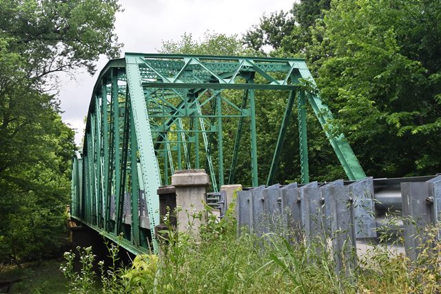
This bridge is a relatively early surviving state standard through truss bridge.
Information and Findings From DHPA Historic Bridge SurveyBridge History and Significance In early September 1927, the Indiana State Highway Commission advertised a letting for the construction of a two-span "steel truss" structure for over Little Pigeon Creek on State Route #66 in Warrick County. Of the seven firms making proposals in late September, the Vincennes Bridge Company brought in the lowest bid at $49,980.65, some six thousand dollars below the engineering estimate. Construction was satisfactorily complete by mid-1929. The state highway engineers followed their standard 150-foot Parker through truss design for this setting, including the concrete substructure and coped and paneled approach rails. Eight panels, demarked by differently sloped top-chord segments, compose each of the two span riveted superstructures. The verticals are made of laced channels. A pair of angles and battens, lighter toward mid-span, provide the diagonals and counters (used only in the two most central panels). The lower chord consists of a pair of angles and battens in the two outer panels and are doubled for the inner ones. Substantial portal and wind bracing support the trusses. The heavy I floor-beams are riveted to the verticals at and above the lower chord and carry the concrete roadway. The through trusses allowed for 17 feet and 6 inches of vertical clearance. The state abandoned this section of S.R. #66 when it moved its route to the north and returned the roadway and the bridge to Warrick County ownership. This bridge represents the earliest standard design for the state's 150-foot Parkers. A number of the members of the west span have been replaced. The guardrail is also contemporary. The original design, though, remains well illustrated, especially in the east span. References Indiana State Highway Commission, Structure 66-B-658; Bridge Department, Division of Construction, "Notice to Bridge Contractors," 9 Sept. 1927; "Tabulation of Awards," 29 Sept. 1927; "Separate Contract Structures Awarded by Bridge Department through 1942: Arranged According to State Roads". MW, Inc., Warrick County Bridge Reinspection Report (Indianapolis, 1978). Engineer Associates, Inc., Bridge Reinspection Report: Warrick County (Evansville, 1981). United Consulting Engineers, Inc., Bridge Reinspection Report: Warrick County (Indianapolis, 1987). WTH Engineering, Warrick County: Bridge Reinspection Report (Indianapolis, 1999). Bridge Considered Historic By Survey: Yes |
![]()
![]()
![]()
Coordinates (Latitude, Longitude):
Search For Additional Bridge Listings:
Bridgehunter.com: View listed bridges within 0.5 miles (0.8 kilometers) of this bridge.
Bridgehunter.com: View listed bridges within 10 miles (16 kilometers) of this bridge.
Additional Maps:
Google Streetview (If Available)
GeoHack (Additional Links and Coordinates)
Apple Maps (Via DuckDuckGo Search)
Apple Maps (Apple devices only)
Android: Open Location In Your Map or GPS App
Flickr Gallery (Find Nearby Photos)
Wikimedia Commons (Find Nearby Photos)
Directions Via Sygic For Android
Directions Via Sygic For iOS and Android Dolphin Browser
USGS National Map (United States Only)
Historical USGS Topo Maps (United States Only)
Historic Aerials (United States Only)
CalTopo Maps (United States Only)

© Copyright 2003-2024, HistoricBridges.org. All Rights Reserved. Disclaimer: HistoricBridges.org is a volunteer group of private citizens. HistoricBridges.org is NOT a government agency, does not represent or work with any governmental agencies, nor is it in any way associated with any government agency or any non-profit organization. While we strive for accuracy in our factual content, HistoricBridges.org offers no guarantee of accuracy. Information is provided "as is" without warranty of any kind, either expressed or implied. Information could include technical inaccuracies or errors of omission. Opinions and commentary are the opinions of the respective HistoricBridges.org member who made them and do not necessarily represent the views of anyone else, including any outside photographers whose images may appear on the page in which the commentary appears. HistoricBridges.org does not bear any responsibility for any consequences resulting from the use of this or any other HistoricBridges.org information. Owners and users of bridges have the responsibility of correctly following all applicable laws, rules, and regulations, regardless of any HistoricBridges.org information.
![]()