

View Information About HSR Ratings
This is a late example of a pin-connected Pratt through truss bridge.
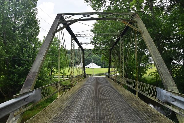
Information and Findings From DHPA Historic Bridge SurveyBridge History and Significance In September 1909, the commissioners received and approved A. N. McPheeter's plans and specifications for a bridge at Murphy Ford on the Valeene and Honey Creek Highway and ordered an October letting. At the letting, the Vincennes Bridge Company made a successful $2,331.24 for the 80-foot steel trussed span and a pair of 24-foot approaches. The superintendent of construction reported satisfactory completion of Vincennes' contract in early April 1910. Seated upon concrete abutments and wingwalls and metal caisson piers. Intermediate verticals of laced channels subdivide the through trusses into most of their five panels. Eyebars provide the diagonals: pairs stretch toward center span from the top panel point to the bottom of the 2nd and 4th panels; cylindrical eyebars with turnbuckles cross the 3rd or center panel. U-bolted to the lower pins, I floor-beams carry the timber deck and allow for 13-feet of vertical roadway clearance. Listed by Hobson and Associates on their short "Schedule of Historic Bridges" in Orange County, this "picturesque" structure appears to retain its original members, including decoratively latticed portals and guardrails. Originally bolted to the pin plates below, the verticals are now welded. References Warren T. Hobson & Associates, Bridge Inspection/Reinspection Report: Orange County (Indianapolis, 1974, 1979, 1996). Orange County, "Commissioners Record," 17: 64, 73-74, 142. Bridge Considered Historic By Survey: Yes (Non-Select) |
![]()
![]()
![]()
Coordinates (Latitude, Longitude):
Search For Additional Bridge Listings:
Bridgehunter.com: View listed bridges within 0.5 miles (0.8 kilometers) of this bridge.
Bridgehunter.com: View listed bridges within 10 miles (16 kilometers) of this bridge.
Additional Maps:
Google Streetview (If Available)
GeoHack (Additional Links and Coordinates)
Apple Maps (Via DuckDuckGo Search)
Apple Maps (Apple devices only)
Android: Open Location In Your Map or GPS App
Flickr Gallery (Find Nearby Photos)
Wikimedia Commons (Find Nearby Photos)
Directions Via Sygic For Android
Directions Via Sygic For iOS and Android Dolphin Browser
USGS National Map (United States Only)
Historical USGS Topo Maps (United States Only)
Historic Aerials (United States Only)
CalTopo Maps (United States Only)

© Copyright 2003-2024, HistoricBridges.org. All Rights Reserved. Disclaimer: HistoricBridges.org is a volunteer group of private citizens. HistoricBridges.org is NOT a government agency, does not represent or work with any governmental agencies, nor is it in any way associated with any government agency or any non-profit organization. While we strive for accuracy in our factual content, HistoricBridges.org offers no guarantee of accuracy. Information is provided "as is" without warranty of any kind, either expressed or implied. Information could include technical inaccuracies or errors of omission. Opinions and commentary are the opinions of the respective HistoricBridges.org member who made them and do not necessarily represent the views of anyone else, including any outside photographers whose images may appear on the page in which the commentary appears. HistoricBridges.org does not bear any responsibility for any consequences resulting from the use of this or any other HistoricBridges.org information. Owners and users of bridges have the responsibility of correctly following all applicable laws, rules, and regulations, regardless of any HistoricBridges.org information.
![]()