

View Information About HSR Ratings
This bridge is one of two very similar and equally noteworthy bridges in Putnam County that are noted for being extremely long examples of pin-connected Pratt truss bridges. Normally for spans these long, Whipple truss spans would have been used. However, these bridges were built toward the end of the pin-connected era, when Whipple truss bridges were not frequently used. During this period it would have been more likely to find a Camelback or a Parker truss doing the job. The use of a simple Pratt for such a long span is uncommon, and the bridges are technologically significant on that basis and give be given preservation priority.
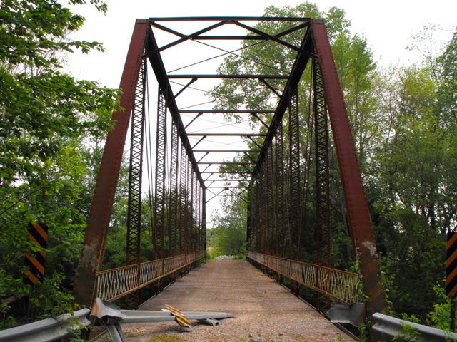
This bridge is abandoned and the county has no plans to reopen the bridge according to the recent historic bridge inventory. The bridge is in a condition however where it could be restored for pedestrian use, either in place or in a new location. Action should be taken sooner rather than later, because the bridge exhibits some unusual deterioration that would be easier to correct now rather than later. Rather that displaying uniform deterioration on similar parts of the bridge, there is quite a contrast. Some of the bottom chord connections are in fantastic condition with very little section loss of the eyebars. Other connections display significant section loss. This deterioration could easily be fixed as part of a comprehensive restoration that might include the careful dismantling of the bridge with restoration of the bridge parts in a shop setting.
Information and Findings From DHPA Historic Bridge SurveyStatement of Significance These long trusses are quite high and their verticals substantial. Otherwise, their design is rather conventional. The bridge retains its original members, including latticed guardrails. Architectural Description Seated upon concrete abutments and wingwalls, this pin-connected Pratt through span extends 162' in ten panels. A pair of laced channels provides each of the verticals, a pair of die-forged eyebars serves as the diagonal sets, and cylindrical rods with turnbuckles counter the diagonals in the six most central panels. The I floor beams are attached to the lower pins. The bridge carries a timber deck with a 15'9" roadway and 24'6" of vertical clearance. Other Information The campaign for "Good Roads" which started in the last decades of the nineteenth century and gained considerable momentum in the early twentieth, led residents of Putnam county to increasingly petition their commissioners for road improvement. Where a road project required the building of a bridge as well as culverts, the commissioners began by the second decade of the twentieth century to weave bridge construction into road-building contracts. In such cases, savvy bidders would have negotiated a price (tentative subcontract) for the required superstructure(s) with a fabricator while calculating the cost of constructing themselves the concrete bridge abutments and culverts along with the road work. The practice of incorporating bridge with road- building contracts came to dominate metal-truss construction in the county from 1910 to 1930. The Houck and the Pinhook Bridges (#139) are like twins having been conceived in 1911, funded in 1912 as part of road projects, and raised in place in 1913. Back-to-back petitions for improved roads in northern Greencastle township led to awards made to prominent local contractors on the same day about a year later. Allen Hurst and Sweet won the contract for the E. E. Black road work with the Pinhook Bridge, and A. M. Lisby and Masten secured the nod for the Ellis Wright road improvement with the Houck Bridge. The Vincennes Bridge Company of Vincennes, Indiana, made most of the long-span superstructures in the county under these road projects. Ellis Wright was joined by 101 others in his petition of 8 May 1911 for "grading, draining, bridging and macadamizing" the road. In June the commissioners appointed A. A. Lane, the county surveyor, and A. J. Owen and John Randolph to assess the proposed improvement. Receiving the viewers report in early June 1912, which estimated the cost of improvement at $13,280.18, the commissioners ordered a letting at the end of the month. Of the seven bids received, commissioners accepted the Lisby and Masten one (for a gravel road) as "the lowest and best." Construction went on under the eye of surveyor A. A. Lane throughout 1913. In July, A. M. Lisby received his biggest payment on the project--$5,380--which probably included the Houck Bridge superstructure. The contractors on the Black and Wright roads must in turn have each subcontracted with the same steel fabricator--quite probably the Vincennes Bridge Company--who made these twin spans. Seated upon concrete abutments and wingwalls which the road contractor had prepared, each pin-connected, Pratt through-truss span extends 162 ft. in ten panels. With a truss-depth of at least 25 ft., the boxed top chords and end-posts were made from a pair of channels, cover plate, and battens riveted together. A pair of die-forged eyebars supply each panel of the lower chord. The truss-web consists of verticals made from a pair of laced and heavy channels (lightest in the outer panel), of diagonals of a pair of die-forged eyebars, and of counter braces in the six most central panels of cylindrical rods with turnbuckles. The I floor-beams are bolted to pin plates. They support rolled I-beam stringers which, with the beams, carries a timber deck with a 16 ft. roadway with 24 feet and 6 inches of vertical clearance. Braced-A portals, upper struts with knee braces, and upper and lower lateral bracing-- of threaded round rods--stiffen the structure. Latticed guardrails line the trusses. The main roadway used since at least the middle of the Nineteenth Century to connect Greencastle with Bainbridge crossed Big Walnut Creek at the location of the Houck Bridge. Both the Houck and the Pinhook Bridges are the longest metal-truss structures in Putnam County, and they each have considerable truss-depth. They were likely designed and made by the Vincennes Bridge Company, a major Indiana bridge fabricator. An important local contractor, who engaged in a considerable number of bridge and road projects in the county, built the substructure and arranged for the purchase of the Houck superstructure. Bridge #146 retains its original members, including its latticed guardrails. Bridge Considered Historic By Survey: Yes
|
![]()
![]()
![]()
Coordinates (Latitude, Longitude):
Search For Additional Bridge Listings:
Bridgehunter.com: View listed bridges within 0.5 miles (0.8 kilometers) of this bridge.
Bridgehunter.com: View listed bridges within 10 miles (16 kilometers) of this bridge.
Additional Maps:
Google Streetview (If Available)
GeoHack (Additional Links and Coordinates)
Apple Maps (Via DuckDuckGo Search)
Apple Maps (Apple devices only)
Android: Open Location In Your Map or GPS App
Flickr Gallery (Find Nearby Photos)
Wikimedia Commons (Find Nearby Photos)
Directions Via Sygic For Android
Directions Via Sygic For iOS and Android Dolphin Browser
USGS National Map (United States Only)
Historical USGS Topo Maps (United States Only)
Historic Aerials (United States Only)
CalTopo Maps (United States Only)

© Copyright 2003-2024, HistoricBridges.org. All Rights Reserved. Disclaimer: HistoricBridges.org is a volunteer group of private citizens. HistoricBridges.org is NOT a government agency, does not represent or work with any governmental agencies, nor is it in any way associated with any government agency or any non-profit organization. While we strive for accuracy in our factual content, HistoricBridges.org offers no guarantee of accuracy. Information is provided "as is" without warranty of any kind, either expressed or implied. Information could include technical inaccuracies or errors of omission. Opinions and commentary are the opinions of the respective HistoricBridges.org member who made them and do not necessarily represent the views of anyone else, including any outside photographers whose images may appear on the page in which the commentary appears. HistoricBridges.org does not bear any responsibility for any consequences resulting from the use of this or any other HistoricBridges.org information. Owners and users of bridges have the responsibility of correctly following all applicable laws, rules, and regulations, regardless of any HistoricBridges.org information.
![]()

