

View Information About HSR Ratings
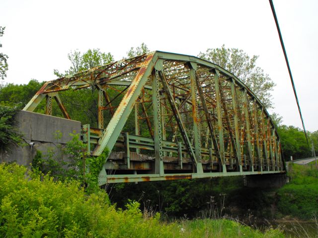
This bridge is a good example of a state standard truss bridge in Indiana. Indiana had a variety of standards for truss bridges that it used in the 20th Century. This is an example of a standard plan that does not include the arched design at the bottom of the sway and portal bracing that is seen on some of the other standard plans. The bridge retains good historic integrity including original railings. There is some damage to the portal bracing due to over-height vehicles crashing into it.
The bridge is in need of rehabilitation, but nothing suggests that the bridge is beyond repair or even that rehabilitation would be overly expensive. This bridge is slated for demolition and replacement, despite several preservation alternatives, including preservation in-place for continued vehicular use, relocation, rehabilitation, and use on a lower volume county road, or relocation for non-motorized traffic.
While Indiana does a relatively excellent job preserving its county owned historic bridges, particularly older metal truss bridges, it has done more poorly with state standard plan truss bridges and truss bridges on state highways. InDOT has shown lacking interest in preserving these important examples that document the evolution of an era where the owner agency determined the design of a bridge rather than the bridge builder as had been done in the century before. This lack of preservation is having devastating consequences in the cohesiveness of Indiana's historic bridge collection, leaving a huge hole in bridge history and development in Indiana. This is unfortunate, because the heavy members and wider decks which characterize this generation of bridges generally lend themselves quite well to carrying 21st Century vehicular traffic.
What appears to be the previous bridge at this crossing on old alignment still remains today, however it was too overgrown during the HistoricBridges.org visit to be feasible to photo-document. It appears to have been abandoned when this bridge was built in 1935.
Information and Findings From DHPA Historic Bridge SurveyStatement of Significance This bridge provides the last-built, extant example of the IDH's adjusted standard plan for 198' Parkers. Aside from the contemporary approach and guardrails, the structure retains its original members. Architectural Description The Indiana Department of Highways selected a
modified version of its longest standard Parker through-truss design as
well as its traditional concrete substructure for this setting. The IDH
stiffened the outer diagonals and the lower chord to accommodate a wider
deck. Other Information The Brookville Bridge Company of Brookville, Ohio, won the contract to build this structure in March 1935 with a bid of $32,444. Brookville Bridge completed the structure by the end of the year. The ISHC relied on a slightly-revised third-generation standard plan (#479A) for this 198-ft., riveted, Parker through-truss span with a 24-ft. roadway seated on concrete abutments. Truss depth varied from 21 ft. 6 in. at the portal to 33 ft. at midspan. Each truss carried eleven 18-ft. panels bounded by verticals made of a pair of laced 10-in. channels (@15.3#, except for the second from the end @20#). To protect the quite-tall trusses against wind and vehicle-induced stress, the verticals are buttressed with substantial latticed struts and heavy upper sway framing above the 15 ft. of roadway clearance. The portals used latticed sections. The diagonals combined angles with battens into heavier members in the outer panels than toward center: in the outermost, two pairs of angles (4"x3.5"Ls); in the second and third, a pair (7"x4"Ls); in the fourth, a pair (3.5"x3"Ls). A pair of angles (4"x3.5"Ls) and battens provide counters in the three most central panels. Each of the top chord's members is differently sloped; only the central panel's is parallel with the lower chord; and all were fabricated from a pair of 15-in. channels getting heavier toward midspan (from 35-50#). Two pairs of angles--all of the same size (6"x4"Ls)--riveted together with battens and buttressed in all but the two most outer panels with plates provide the lower chord's members. The ISHC used 33-in. I floor-beams (@141#) riveted to the verticals above the lower chord. Eight rows of heavier rolled I stringers (16"@40#) are attached to the floor-beams' sides. Together, the floor-beams and the stringers carry the concrete deck. A pair of angles supplies each lower sway bracing member. Latticed hand rails originally lined the inner sides of all the trusses, and coped concrete parapets with bush-hammered panels provided approach rails. This structure exemplifies an important, revised, third-generation ISHC standard plan. The trusses retain their original members. The latticed guard rails lining the trusses, the concrete railings of the approaches, and the concrete deck have been replaced. A notable Ohio fabricator- builder erected this structure. Bridge Considered Historic By Survey: Yes |
![]()
![]()
![]()

![]()
![]()
This historic bridge has been demolished. This map is shown for reference purposes only.
Coordinates (Latitude, Longitude):
Search For Additional Bridge Listings:
Bridgehunter.com: View listed bridges within 0.5 miles (0.8 kilometers) of this bridge.
Bridgehunter.com: View listed bridges within 10 miles (16 kilometers) of this bridge.
Additional Maps:
Google Streetview (If Available)
GeoHack (Additional Links and Coordinates)
Apple Maps (Via DuckDuckGo Search)
Apple Maps (Apple devices only)
Android: Open Location In Your Map or GPS App
Flickr Gallery (Find Nearby Photos)
Wikimedia Commons (Find Nearby Photos)
Directions Via Sygic For Android
Directions Via Sygic For iOS and Android Dolphin Browser
USGS National Map (United States Only)
Historical USGS Topo Maps (United States Only)
Historic Aerials (United States Only)
CalTopo Maps (United States Only)

© Copyright 2003-2024, HistoricBridges.org. All Rights Reserved. Disclaimer: HistoricBridges.org is a volunteer group of private citizens. HistoricBridges.org is NOT a government agency, does not represent or work with any governmental agencies, nor is it in any way associated with any government agency or any non-profit organization. While we strive for accuracy in our factual content, HistoricBridges.org offers no guarantee of accuracy. Information is provided "as is" without warranty of any kind, either expressed or implied. Information could include technical inaccuracies or errors of omission. Opinions and commentary are the opinions of the respective HistoricBridges.org member who made them and do not necessarily represent the views of anyone else, including any outside photographers whose images may appear on the page in which the commentary appears. HistoricBridges.org does not bear any responsibility for any consequences resulting from the use of this or any other HistoricBridges.org information. Owners and users of bridges have the responsibility of correctly following all applicable laws, rules, and regulations, regardless of any HistoricBridges.org information.
![]()