

View Information About HSR Ratings
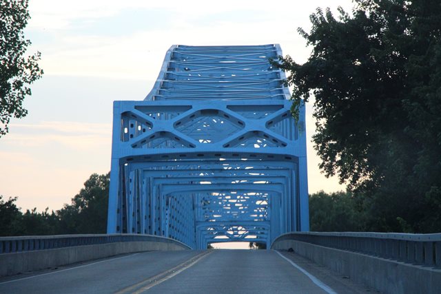
This large bridge over a big river and an area called Herman Island is hidden away in a thickly forested area along the river that this highway passes through. Despite being a large bridge over a big river, this is a very difficult bridge to photograph. Typically large river bridges like this are located near cities or population areas, but this bridge is in the middle of nowhere, and surrounded by thick woods. If anyone has made the trek through the woods or taken a boat down the river or perhaps even flown a drone and got photos of this bridge and is willing to share, please contact us!
It is believed that the bridge was designed by Sverdrup and Parcel, as a historical article stated that they did the surveys for the bridge and they were the company that accepted bids.
Bridges of this style are often difficult to classify. This bridge has an arch section that springs from the piers like the Julien Dubuque Bridge, rather than springing from cantilever arms like the Paris Road Bridge. For this reason the bridge appears to function as a continuous tied arch. WJE Engineers reports the bridge as a "three-span, tied arch through-truss bridge" which seems to match this assessment. As such, the bridge is not a pure truss bridge with a suspended deck, it has a tied arch over the main span, and trusses on the side spans, all functioning as a continuous unit. In other words, with no hinges like those seen on the Paris Road Bridge.

Above: Historical photo showing bridge construction from The Decatur Daily Review: October 2 1955.
This bridge is tagged with the following special condition(s): Unorganized Photos
![]()
![]()
![]()
Coordinates (Latitude, Longitude):
Search For Additional Bridge Listings:
Bridgehunter.com: View listed bridges within 0.5 miles (0.8 kilometers) of this bridge.
Bridgehunter.com: View listed bridges within 10 miles (16 kilometers) of this bridge.
Additional Maps:
Google Streetview (If Available)
GeoHack (Additional Links and Coordinates)
Apple Maps (Via DuckDuckGo Search)
Apple Maps (Apple devices only)
Android: Open Location In Your Map or GPS App
Flickr Gallery (Find Nearby Photos)
Wikimedia Commons (Find Nearby Photos)
Directions Via Sygic For Android
Directions Via Sygic For iOS and Android Dolphin Browser
USGS National Map (United States Only)
Historical USGS Topo Maps (United States Only)
Historic Aerials (United States Only)
CalTopo Maps (United States Only)

© Copyright 2003-2024, HistoricBridges.org. All Rights Reserved. Disclaimer: HistoricBridges.org is a volunteer group of private citizens. HistoricBridges.org is NOT a government agency, does not represent or work with any governmental agencies, nor is it in any way associated with any government agency or any non-profit organization. While we strive for accuracy in our factual content, HistoricBridges.org offers no guarantee of accuracy. Information is provided "as is" without warranty of any kind, either expressed or implied. Information could include technical inaccuracies or errors of omission. Opinions and commentary are the opinions of the respective HistoricBridges.org member who made them and do not necessarily represent the views of anyone else, including any outside photographers whose images may appear on the page in which the commentary appears. HistoricBridges.org does not bear any responsibility for any consequences resulting from the use of this or any other HistoricBridges.org information. Owners and users of bridges have the responsibility of correctly following all applicable laws, rules, and regulations, regardless of any HistoricBridges.org information.
![]()