

View Information About HSR Ratings

This webpage and narrative you are currently viewing is for one of the seven historic bridges that have been relocated to F. W. Kent Park on the Rod Dunlap Memorial Bridge Trail. This page provides a discussion of the individual bridge. Please also view the Dane Road Bridge page which includes a general overview discussion of F. W. Kent Park on the Rod Dunlap Memorial Bridge Trail. The map on this page shows F. W. Kent Park with all seven bridges labeled. You can click on the name of a bridge to switch to a particular bridge's page. Visit the official page for the park here. If you want to view an enlarged version of the bridge map to the left, click here.
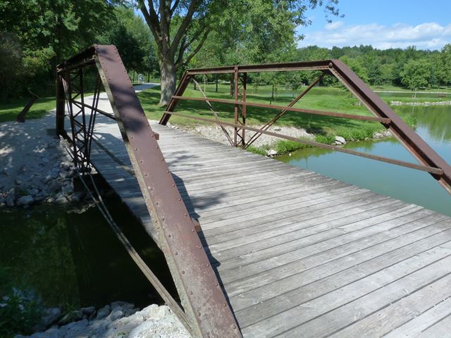
This bridge was previously located on Bayertown Road crossing Dirty Face Creek in Liberty Township. With only two panels, this is the least number of panels that a Pratt truss can have. As such, this is a short bridge with an estimated length of 35 feet. The bridge was reportedly built by the King Iron Bridge Company of Cleveland, Ohio, a prolific bridge builder in the late 1800s and early 1900s. This bridge is a traditionally composed example of its type. Little bridges like this are often overlooked for preservation because of their small size. As such, this is a rare example of such a small bridge being preserved. While preserving large bridges is important, it is also important to preserve small bridges like this one to ensure that a complete picture of our nation's transportation past is kept alive.
![]()
![]()
![]()
Coordinates (Latitude, Longitude):
Search For Additional Bridge Listings:
Bridgehunter.com: View listed bridges within 0.5 miles (0.8 kilometers) of this bridge.
Bridgehunter.com: View listed bridges within 10 miles (16 kilometers) of this bridge.
Additional Maps:
Google Streetview (If Available)
GeoHack (Additional Links and Coordinates)
Apple Maps (Via DuckDuckGo Search)
Apple Maps (Apple devices only)
Android: Open Location In Your Map or GPS App
Flickr Gallery (Find Nearby Photos)
Wikimedia Commons (Find Nearby Photos)
Directions Via Sygic For Android
Directions Via Sygic For iOS and Android Dolphin Browser
USGS National Map (United States Only)
Historical USGS Topo Maps (United States Only)
Historic Aerials (United States Only)
CalTopo Maps (United States Only)

© Copyright 2003-2024, HistoricBridges.org. All Rights Reserved. Disclaimer: HistoricBridges.org is a volunteer group of private citizens. HistoricBridges.org is NOT a government agency, does not represent or work with any governmental agencies, nor is it in any way associated with any government agency or any non-profit organization. While we strive for accuracy in our factual content, HistoricBridges.org offers no guarantee of accuracy. Information is provided "as is" without warranty of any kind, either expressed or implied. Information could include technical inaccuracies or errors of omission. Opinions and commentary are the opinions of the respective HistoricBridges.org member who made them and do not necessarily represent the views of anyone else, including any outside photographers whose images may appear on the page in which the commentary appears. HistoricBridges.org does not bear any responsibility for any consequences resulting from the use of this or any other HistoricBridges.org information. Owners and users of bridges have the responsibility of correctly following all applicable laws, rules, and regulations, regardless of any HistoricBridges.org information.
![]()