

View Information About HSR Ratings
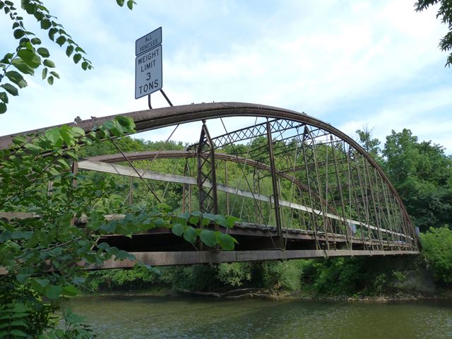
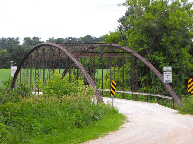
Some entire states do not have a single 1870s bowstring truss bridge. Winneshiek County however has several, and each are nationally significant as rare surviving examples of bridges built during one of the most important periods in the history of bridge construction. The Gilliece Bridge is one of those bridges, and it retains excellent historic integrity, due to a lack of alteration over its extremely long service life. It is also significant because as a slightly smaller bridge, it was built to a different design and it has different structural details than the other two larger bridges in the county, making this bridge an excellent comparison to the design followed on the other two bridges. Wrought Iron Bridge Company followed the same general design, but they did have differences that changed depending on when the bridge was built, what the customer selected, and the size of the span.
The Gilliece Bridge is also one of the last historic bowstring truss bridges that remains open to vehicular traffic.
The bridge includes typical Wrought Iron Bridge Company bowstring details as outlined in the original patent. The top chord is a Keystone column. Sway and portal bracing are latticed. There are cast iron connection assemblies on the bridge. Unusual etch marks on edges of the metal on the keystone column top chord at rivet points appear to have been some sort of measurement aid, the exact purpose of which is unknown. The Gilliece Bridge has a different connection detail than the other two Wrought Iron Bridge Company bowstrings in the county, at the bridge shoe assembly at the ends of the bottom chord. Instead of the two large bolts that hold the bottom chord in place, the bottom chord is connected by a pin. In contrast, the bottom chord segments between the ends are riveted rather than pinned, whereas on the other bridges in the county they are pinned. Also, this bridge has floorbeams that are made up of two rolled beams, rather than the riveted fishtail floorbeams seen on the other Wrought Iron Bridge bowstrings in the county.
Bowstring truss bridges are sometimes called bowstring arch bridges because they have similarities to both structure types. Beginning with Squire Whipple's Whipple Arch Bridges, such as the Ehrmentraut Farm Bridge, the bowstring truss bridge is the bridge type that began a transition away from wood and stone and began to make metal a common bridge building material. It also began a period of experimentation until a good bridge form was developed, leading to a gradual standardization of bridge design. During this period, numerous bridge companies all experimented with metal, trying to design the best bridge. Each company had their own distinctive bowstring design, including unique and creative design details. These designs were often patented. Most bowstring truss bridges were built in the 1870s. Also during this time, cast iron was still used in addition to wrought iron for the construction of bridges, so many bowstrings built during this period include details such as connection assemblies that are made of cast iron. By the 1880s, bridge companies decided that the pin-connected Pratt truss was a better structure type, and construction of bowstring bridges sharply dropped after 1880. Because of the period in which Iowa was first being settled, a much larger number of bowstring truss bridges were built in the state than in other states. As a result, even today, Iowa has more historic bowstring truss bridges than any other state, although the number of bridges statewide is under 20, a very small number. However, a number of states do not have even a single historic bowstring truss within their borders. As such, while bowstring truss bridges are very few in number in Iowa, they are extremely rare on a national scale. It is imperative that each surviving bowstring in the county be preserved to protect this key period in bridge building history.
Historic American Engineering Record created a large and very informative historical overview and context for Iowa's bridges, and it is offered here by HistoricBridges.org in convenient PDF format for easy printing or offline viewing. The HAER source for the documents composing the PDF is here.
In its discussion about a single bowstring bridge, Historic American Engineering Record included a detailed description of the Wrought Iron Bridge Company and a general history and discussion of its bowstring truss bridges in general. HistoricBridges.org has clipped this section for convenient viewing in PDF format. The HAER source for the documents composing the PDF is here.
View Bowstring Arch Bridges of Iowa, An Online Book By Michael Finn (PDF)Michael Finn has composed a concise and detailed overview of Iowa's beautiful historic bowstring bridges. It has been made available for free by Iowa Department of Transportation.
View Historic American Engineering Record's Structural Analysis of Iron Bowstring Bridges (PDF)Historic American Engineering Record created a large and very informative structural analysis of how bowstring truss/arch bridges function. Everything from basic discussion of the engineering behind the bridges to advanced mathematical equations are available. The HAER source for the documents composing the PDF is here.
Information and Findings From Iowa's Historic Bridge InventoryDiscussion of Bridge Known locally as the Gilliece Bridge, this bowstring
through arch and wrought-iron truss is supported by a stone substructure
and is approached on the north end by a steel stringer. The bridge dates
to 1874, but traces its history some two years earlier. After decades of
building short-span timber and stone bridges, Winneshiek County began
contracting for all-iron superstructures in 1872; three bridges were
built the next year, the Daubersmith Bridge, the Fort Atkinson Bridge
and the Gilliece Bridge. Local stonemason Thomas Dwyer built the massive
masonry abutments, which, according to county bridge commissioner George
Winship, were "by far the best job of masonry in the county, so noted by
all who have seen it." The abutments and 95-foot wingwalls consumed
almost 212 cords of limestone and 17,898 feet of timber and plank.
Ironically, Dwyer stood to lose money on the project if the
commissioners had not decided to pay the stonemason an extra $215 for
his work because, they reasoned, it was "not fair that the many should
benefit at the expense of one poor man." As it had for the preceding two
spans, the county purchased a bowstring arch-truss form the Wrought Iron
Bridge Company of Canton, Ohio. Completed in 1874, the Gilliece Bridge
cost $6,969.47. Bridge Considered Historic By Survey: Yes |
This bridge is tagged with the following special condition(s): Keystone Columns
![]()
![]()
![]()
![]()
![]()

![]()
![]()
![]()
This historic bridge has been demolished. This map is shown for reference purposes only.
Coordinates (Latitude, Longitude):
Search For Additional Bridge Listings:
Bridgehunter.com: View listed bridges within 0.5 miles (0.8 kilometers) of this bridge.
Bridgehunter.com: View listed bridges within 10 miles (16 kilometers) of this bridge.
Additional Maps:
Google Streetview (If Available)
GeoHack (Additional Links and Coordinates)
Apple Maps (Via DuckDuckGo Search)
Apple Maps (Apple devices only)
Android: Open Location In Your Map or GPS App
Flickr Gallery (Find Nearby Photos)
Wikimedia Commons (Find Nearby Photos)
Directions Via Sygic For Android
Directions Via Sygic For iOS and Android Dolphin Browser
USGS National Map (United States Only)
Historical USGS Topo Maps (United States Only)
Historic Aerials (United States Only)
CalTopo Maps (United States Only)

© Copyright 2003-2024, HistoricBridges.org. All Rights Reserved. Disclaimer: HistoricBridges.org is a volunteer group of private citizens. HistoricBridges.org is NOT a government agency, does not represent or work with any governmental agencies, nor is it in any way associated with any government agency or any non-profit organization. While we strive for accuracy in our factual content, HistoricBridges.org offers no guarantee of accuracy. Information is provided "as is" without warranty of any kind, either expressed or implied. Information could include technical inaccuracies or errors of omission. Opinions and commentary are the opinions of the respective HistoricBridges.org member who made them and do not necessarily represent the views of anyone else, including any outside photographers whose images may appear on the page in which the commentary appears. HistoricBridges.org does not bear any responsibility for any consequences resulting from the use of this or any other HistoricBridges.org information. Owners and users of bridges have the responsibility of correctly following all applicable laws, rules, and regulations, regardless of any HistoricBridges.org information.
![]()