

View Information About HSR Ratings
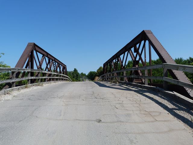
This is a design of bridge that is in general highly unusual, but can be found on multiple highway over railroad type bridges. They are likely the design of the railroad company... although highway bridges, some of the design is more typical of a railroad bridge. The unusual design lies in the composition of the truss members, which are a combination of angles and plate. This gives the bridge's truss members visually a somewhat more two-dimensional appearance compared to most truss bridges. A series of timber approach spans are also present at each end of this bridge. There is a dramatic "hump" to this bridge.
This bridge is noteworthy as an unusual example of a bridge with riveted connections yet has floor beams hung by u-bolts. U-bolts were more common with pin-connected truss bridge. However, this bridge's u-bolts do not use a pin and instead are riveted to the vertical member.
This bridge shows signs of alteration. An outrigger is missing at one end of the bridge. Also, something has been removed from the trusses at a number of additional points. Empty rivet holes are testimony to this. It is not sure what was removed, it might have been an outrigger, or it might have been a full-blown vertical member. Either way its a mystery since it is unclear why these elements which provide a benefit to the truss structure would be removed.
A ca. 1940 date was found on www.bridgehunter.com for this bridge. This bridge appears to be older than that. Perhaps the 1940 date refers to a relocation date. This may be when the alterations occurred as well... or perhaps the date refers only to the alteration of this bridge, and the bridge was never relocated. Or the date could be a complete error. It is a mystery!
![]()
![]()
![]()
Coordinates (Latitude, Longitude):
Search For Additional Bridge Listings:
Bridgehunter.com: View listed bridges within 0.5 miles (0.8 kilometers) of this bridge.
Bridgehunter.com: View listed bridges within 10 miles (16 kilometers) of this bridge.
Additional Maps:
Google Streetview (If Available)
GeoHack (Additional Links and Coordinates)
Apple Maps (Via DuckDuckGo Search)
Apple Maps (Apple devices only)
Android: Open Location In Your Map or GPS App
Flickr Gallery (Find Nearby Photos)
Wikimedia Commons (Find Nearby Photos)
Directions Via Sygic For Android
Directions Via Sygic For iOS and Android Dolphin Browser
USGS National Map (United States Only)
Historical USGS Topo Maps (United States Only)
Historic Aerials (United States Only)
CalTopo Maps (United States Only)

© Copyright 2003-2024, HistoricBridges.org. All Rights Reserved. Disclaimer: HistoricBridges.org is a volunteer group of private citizens. HistoricBridges.org is NOT a government agency, does not represent or work with any governmental agencies, nor is it in any way associated with any government agency or any non-profit organization. While we strive for accuracy in our factual content, HistoricBridges.org offers no guarantee of accuracy. Information is provided "as is" without warranty of any kind, either expressed or implied. Information could include technical inaccuracies or errors of omission. Opinions and commentary are the opinions of the respective HistoricBridges.org member who made them and do not necessarily represent the views of anyone else, including any outside photographers whose images may appear on the page in which the commentary appears. HistoricBridges.org does not bear any responsibility for any consequences resulting from the use of this or any other HistoricBridges.org information. Owners and users of bridges have the responsibility of correctly following all applicable laws, rules, and regulations, regardless of any HistoricBridges.org information.
![]()