

View Information About HSR Ratings
This double-deck bridge has a long approach system for the upper deck only. Bridge length given includes the approach system. The lower deck overall length is limited to the main truss spans only, a total of 750 feet.
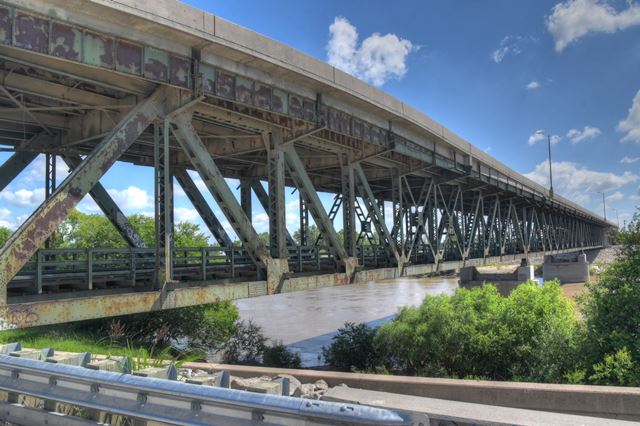
Be sure to view the historical articles which contain some photos and description of this bridge. This bridge consists of a double-deck truss system over the river, with a long approach system serving the upper deck of the bridge as well. The bridge has been transformed over the years. An unusual fact about this bridge is the upper deck, currently supporting four lanes of traffic, is actually narrower than it was originally. The bridge was originally designed with an upper deck that accommodated streetcars on one side and highway traffic on the other. It was noted by engineers of the period that despite this asymmetrical roadway layout (and loading), the bridge superstructure was nevertheless designed in a visually symmetrical manner. Later in this bridge's history, the streetcar rails were removed. Cantilever brackets that extended the deck well beyond the truss lines were partially cut off, and the deck was turned into a highway-only configuration. The approach spans have been heavily reworked over the years as well, with the bridge today being integral with an I-670 Interchange.
The lower deck of this bridge remains open to vehicular traffic, but it appears to be little-used.

Above: Historical photo showing bridge construction.
![]()
![]()
![]()
Coordinates (Latitude, Longitude):
Search For Additional Bridge Listings:
Bridgehunter.com: View listed bridges within 0.5 miles (0.8 kilometers) of this bridge.
Bridgehunter.com: View listed bridges within 10 miles (16 kilometers) of this bridge.
Additional Maps:
Google Streetview (If Available)
GeoHack (Additional Links and Coordinates)
Apple Maps (Via DuckDuckGo Search)
Apple Maps (Apple devices only)
Android: Open Location In Your Map or GPS App
Flickr Gallery (Find Nearby Photos)
Wikimedia Commons (Find Nearby Photos)
Directions Via Sygic For Android
Directions Via Sygic For iOS and Android Dolphin Browser
USGS National Map (United States Only)
Historical USGS Topo Maps (United States Only)
Historic Aerials (United States Only)
CalTopo Maps (United States Only)

© Copyright 2003-2024, HistoricBridges.org. All Rights Reserved. Disclaimer: HistoricBridges.org is a volunteer group of private citizens. HistoricBridges.org is NOT a government agency, does not represent or work with any governmental agencies, nor is it in any way associated with any government agency or any non-profit organization. While we strive for accuracy in our factual content, HistoricBridges.org offers no guarantee of accuracy. Information is provided "as is" without warranty of any kind, either expressed or implied. Information could include technical inaccuracies or errors of omission. Opinions and commentary are the opinions of the respective HistoricBridges.org member who made them and do not necessarily represent the views of anyone else, including any outside photographers whose images may appear on the page in which the commentary appears. HistoricBridges.org does not bear any responsibility for any consequences resulting from the use of this or any other HistoricBridges.org information. Owners and users of bridges have the responsibility of correctly following all applicable laws, rules, and regulations, regardless of any HistoricBridges.org information.
![]()