

View Information About HSR Ratings

The consulting engineer for this bridge and the similar Eggner's Ferry Bridge was J. M. Johnson. Little is known about this engineer. A search online revealed a J. M. Johnson who in the years before this bridge was built worked for the Louisville Bridge and Iron Company (a noteworthy company that was originally formed by famous engineer Albert Fink) and this may be the same engineer, who later went off and did independent consulting as seen with this bridge.
Both the Lake Barkley and Eggner's Ferry Bridge include built-up diagonal members in the through truss spans that are unusually configured as back-to-back channels with diaphragms between which are composed of riveted plate and angles. This is an unusual design of built-up beam that may be unique to these bridges.
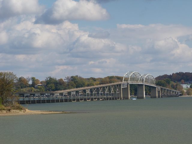
The Lake Barkey Bridge has two main Parker through truss spans. There is a single small deck truss span at both ends of the main span portion of the bridge. The remainder of the bridge consists of steel stringer approach spans that are constructed at a fairly steep grade to get the road up to the desired level over the waterway.

Kentucky has decided that the best way to deal with its impressive collection of large, long-span historic truss bridges in western Kentucky would be to reduce all of them to scrap metal and replace them with ugly modern bridges. This is a very disappointing decision. While it is understandable that not every historic truss bridge is feasible to preserve, its pretty ridiculous to claim that it is not possible to preserve even one example. Yet pretty much every large, long-span metal truss bridge in Western Kentucky is either demolished, slated for demolition, or currently being demolished. It was this unchecked slaughter of our nation's transportation heritage that prompted HistoricBridges.org to photo-document the bridges in late 2013.
With this bridge, it is to be replaced as part of the same project that is also replacing the Eggner's Ferry Bridge. After the Lake Barkley Bridge is demolished, all that will remain of the historic bridge is a little interpretive sign as shown to the right.
Information and Findings From Replacement Project StudiesOverview The Henry R. Lawrence Memorial Bridge spans Lake Barkley (Cumberland River) from Land Between the Lakes to Canton in Trigg County. Its location is shown in Figure 2 of the FONSI. At the conclusion of the first phase of the statewide bridge survey in 1982, the Henry R. Lawrence Memorial Bridge was determined to meet National Register criterion A because it was a "part of the Barkley Lake-Cumberland River project... which caused the displacement of a large portion of the region's population in the early twentieth century". The boundaries of this National Register-eligible resource are the structure and earthen embankment contained between the two shorelines of Lake Barkley. Functional Characteristics The west approach to the bridge is on an earthen embankment about seven meters (23 feet) above the water level. The western embankment extends about one-third of the way to the river channel (200 meters/656 feet); the remaining distance (461 meters/1,512 feet) is bridged by short steel beam spans. The Cumberland River main channel is crossed by two deck truss spans and two through truss main spans (270 meters/886 feet total). The east approach continues across the lake to the eastern shore ( 415 meters/1,361 feet) with about equal lengths of steel beam spans and earthen embankment. The bridge has 6.1 meters (20 feet) of clearance between the guard rails. Existing deficiencies of this bridge are described in section II of the FONSI under 'Roadway and Major Bridge Deficiencies.' These deficiencies include: narrow lanes, no shoulders, fractured and damaged members, inadequate seismic resistance strength, and an undesirable horizontal navigation clearance, The bridge is owned by the State of Kentucky and maintained by the Kentucky Department of Highways. It is an integral part of US 68/KY 80, a principal east-west highway in Western Kentucky. US 68/KY 80 also serves as the only east-west highway into and through the Land Between the Lakes. The Lawrence Memorial Bridge connects the recreation opportunities offered by Lake Barkley State Resort Park (on the eastern shore Lake Barkley) with the Land Between the Lakes. (See Figure 2 of the FONS!.) Pedestrians and bicyclists cannot safely use the bridge because of its narrow width. Historical Characteristics The initial construction of the bridge, which was first called the Canton Bridge, may have been financed by a Kentucky Bridge Revenue Bond authorized by the Murphey Toll Bridge Act of 1928. This is the same law under which the Eggner's Ferry Bridge and other Cumberland River and Tennessee River bridges were financed (listed in the Eggner's Ferry Bridge discussion above). The Lawrence Bridge is a memorial to Henry R. Lawrence, a western Kentucky newspaperman and 'good roads' advocate. The Cadiz editor labored long to provide highways and bridge facilities for his section of Kentucky ('Lawrence Bridge Courier Journal. August 6, 1933, Section 4, p. 8). In 1962, the Lawrence Bridge was closed so that engineers could raise it 3.2 meters ( 10.5 feet) to provide clearance for the impoundment of Lake Barkley. Two ferry boats handled the traffic until the bridge reopened in December 1963 ("Canton Bridge May Open December 15". Courier Journal. November 13, 1963, Section 2, p. 3). |
![]()
![]()
![]()
This historic bridge has been demolished. This map is shown for reference purposes only.
Coordinates (Latitude, Longitude):
Search For Additional Bridge Listings:
Bridgehunter.com: View listed bridges within 0.5 miles (0.8 kilometers) of this bridge.
Bridgehunter.com: View listed bridges within 10 miles (16 kilometers) of this bridge.
Additional Maps:
Google Streetview (If Available)
GeoHack (Additional Links and Coordinates)
Apple Maps (Via DuckDuckGo Search)
Apple Maps (Apple devices only)
Android: Open Location In Your Map or GPS App
Flickr Gallery (Find Nearby Photos)
Wikimedia Commons (Find Nearby Photos)
Directions Via Sygic For Android
Directions Via Sygic For iOS and Android Dolphin Browser
USGS National Map (United States Only)
Historical USGS Topo Maps (United States Only)
Historic Aerials (United States Only)
CalTopo Maps (United States Only)

© Copyright 2003-2024, HistoricBridges.org. All Rights Reserved. Disclaimer: HistoricBridges.org is a volunteer group of private citizens. HistoricBridges.org is NOT a government agency, does not represent or work with any governmental agencies, nor is it in any way associated with any government agency or any non-profit organization. While we strive for accuracy in our factual content, HistoricBridges.org offers no guarantee of accuracy. Information is provided "as is" without warranty of any kind, either expressed or implied. Information could include technical inaccuracies or errors of omission. Opinions and commentary are the opinions of the respective HistoricBridges.org member who made them and do not necessarily represent the views of anyone else, including any outside photographers whose images may appear on the page in which the commentary appears. HistoricBridges.org does not bear any responsibility for any consequences resulting from the use of this or any other HistoricBridges.org information. Owners and users of bridges have the responsibility of correctly following all applicable laws, rules, and regulations, regardless of any HistoricBridges.org information.
![]()