

View Information About HSR Ratings

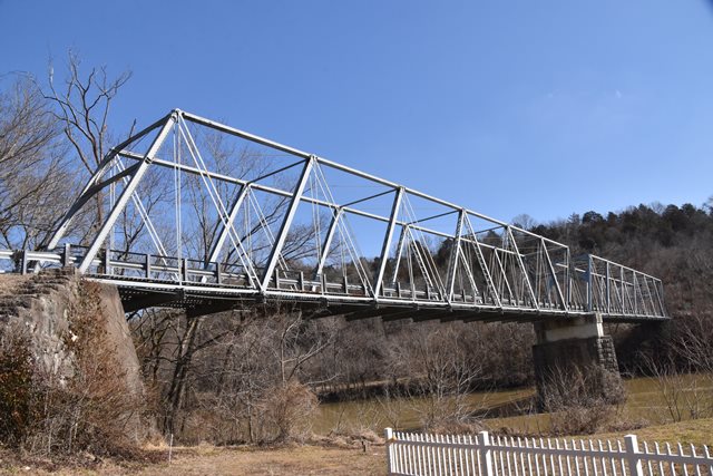
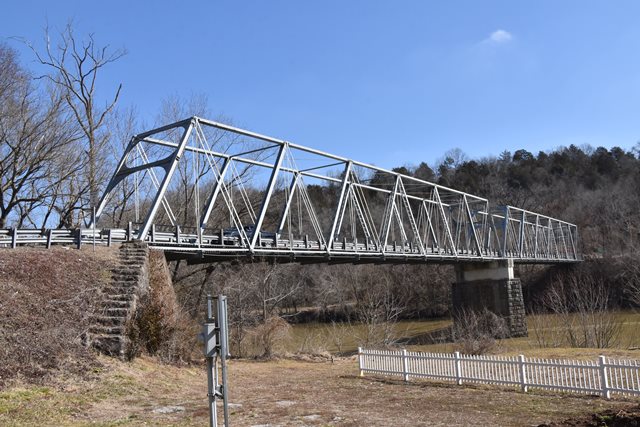
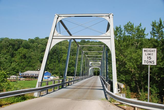
This bridge is one of the most important historic bridges in Kentucky. Several aspects of this bridge make it nationally significant. First, the bridge was built in 1869, which makes it among the oldest metal bridges in the country. Any metal bridge dating to before 1870 is exceedingly rare in North America. The other most significant aspect of this bridge is its use of cast iron for primary structural members, which is one of the rarest features to be found on a historic bridge. Cast iron truss bridges are one of the rarest types of historic bridge in the country. This bridge uses cast iron for its top chord. Additionally, the struts for this bridge are also cast iron. Finally, the bridge is also significant as a rare example of a pin-connected Warren truss. Warren trusses usually have riveted connections.
Little was known about the history of this bridge's design and construction. HistoricBridges.org located an advertisement on the Kentucky Digital Library listing the Louisville Bridge and Iron Company of Louisville, Kentucky, so this is who HistoricBridges.org is listing as the main builder for the bridge. Previously, Madison County Historical society suggested that William Gunn built the bridge. It is not known if this is speculation, or if he was perhaps the on-site contractor who erected the bridge. Madison County Historical provided the following information about Gunn:
William Gunn was born in North Carolina in 1797. He became an itinerant preacher for the Methodist Episcopal Church's Henderson, Kentucky circuit in 1819. He married Frances Adams, the daughter of a Shelbyville, Kentucky, Methodist minister, in 1826. Their children included William Gunn the younger, who was an engineer and inventor. During the Civil War, he served as chief engineer of the U.S. Military Railroad and constructed several forts in Kentucky. After the war, he built the bridge at Clay's Ferry, Kentucky and invented the "H" column for steel construction.
The history of the bridge's use is a little more well documented. Before there was a bridge here, someone named Green Clay operated a ferry service here, accounting for the name of the bridge. The bridge was built in 1869 for the Richmond and Lexington Turnpike. The bridge was purchased by the State of Kentucky in 1929 and became part of US-25 until a larger high level bridge was built to realign US-25 in 1946. Since then, the cast iron truss has carried local traffic only. The bridge was rehabilitated in 1955. At some point, the top of the pier was removed and replaced with concrete. The primary substructure material is stone, although concrete has been used to repair the abutments as well.
![]()
![]()
![]()
![]()
![]()
Coordinates (Latitude, Longitude):
Search For Additional Bridge Listings:
Bridgehunter.com: View listed bridges within 0.5 miles (0.8 kilometers) of this bridge.
Bridgehunter.com: View listed bridges within 10 miles (16 kilometers) of this bridge.
Additional Maps:
Google Streetview (If Available)
GeoHack (Additional Links and Coordinates)
Apple Maps (Via DuckDuckGo Search)
Apple Maps (Apple devices only)
Android: Open Location In Your Map or GPS App
Flickr Gallery (Find Nearby Photos)
Wikimedia Commons (Find Nearby Photos)
Directions Via Sygic For Android
Directions Via Sygic For iOS and Android Dolphin Browser
USGS National Map (United States Only)
Historical USGS Topo Maps (United States Only)
Historic Aerials (United States Only)
CalTopo Maps (United States Only)

© Copyright 2003-2024, HistoricBridges.org. All Rights Reserved. Disclaimer: HistoricBridges.org is a volunteer group of private citizens. HistoricBridges.org is NOT a government agency, does not represent or work with any governmental agencies, nor is it in any way associated with any government agency or any non-profit organization. While we strive for accuracy in our factual content, HistoricBridges.org offers no guarantee of accuracy. Information is provided "as is" without warranty of any kind, either expressed or implied. Information could include technical inaccuracies or errors of omission. Opinions and commentary are the opinions of the respective HistoricBridges.org member who made them and do not necessarily represent the views of anyone else, including any outside photographers whose images may appear on the page in which the commentary appears. HistoricBridges.org does not bear any responsibility for any consequences resulting from the use of this or any other HistoricBridges.org information. Owners and users of bridges have the responsibility of correctly following all applicable laws, rules, and regulations, regardless of any HistoricBridges.org information.
![]()