

View Information About HSR Ratings

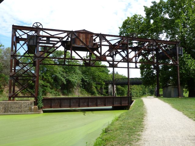
This bridge is an extremely small-scale vertical lift bridge. With a plate girder main span it provides a short span of 40 feet, and an equally meager lifting distance of only 15 feet. It is quite a contrast to large-scale vertical lift bridges like those found in Chicago. However, this small-scale design met the needs for the canal it crosses. In fact, the bridge was specifically designed with some unusual features to accommodate the canal, which operated in the traditional fashion of using a tow path which animals would be used to tow the boats through the canal. The bridge being designed with overhead counterweights and the machinery house also housed on an overhead truss system, one would expect the support bents for this structure to be located immediately at each end of the span. However, an animal pulling a boat along the canal with a rope would not be able to pass by the bridge since the supports would block the rope, even when the bridge was raised. As such, a special design was used. On the southern end of the bridge, the overhead truss was extended so that the main bents supporting the overhead truss are located on the far side of the tow path. Additionally, the guide column that keeps the girder span stable on the southern end of the span was designed so that it raises along with the girder span and cables. Therefore, when the bridge is in the raised position, a clear, unobstructed opening of 70 feet, including the tow path, is realized, which would allow the boats to be towed under the bridge. The bridge was built to connect the Western Maryland Railway line to a new elected power generating plant being constructed at the time. It replaced a temporary bridge at the location. All this creative engineering turned out to be for naught however. The bridge was completed in 1923 and operated for part of that year. In March 1924, a massive flood destroyed enough of the canal that between the destruction and the decreased use of an old-fashioned canal in a world of railroads and motor vehicles resulted in the canal being abandoned. Thus, the need for this bridge to be movable only lasted for a matter of months of its existence. Despite this, the vertical lift portions of the bridge were never removed, and they remain today. The railroad line has been abandoned today, but the bridge remains and is part of the canal park. To get an idea of what this 1924 flood may have been like, the photo to the right shows a massive flood that occurred in 1936. The bridge is in its raised position, to try to get the girder out of the rapidly flowing water. The truss bridge in the foreground also remains today.


The Historic American Engineering Record documentation mentions that although the bridge was constructed for the Potomac Edison Company and its power plant, the railroad company took the leadership in its design. This may be, however it seems possible that the Potomac Edison Company may have had some form of input in the bridge because the engineer hired to design the bridge and the superstructure contractor both appear to have specialized in power generation related things, and do not appear to be companies who specialized in movable bridge design like Strauss Bascule Bridge Company, Waddell and Harrington, etc. Engineers Sanderson and Porter list hydroelectric, electric light, and gas among their specialties in period advertisements. Superstructure contractor New York Central Iron Works specialized in steel tanks, also something that would have been part of power generation facilities.


When visiting this bridge it is unfortunately not possible to ignore the nearby long highway bridge over the canal and the Potomac River. The bridge has old looking concrete piers, with a modern and horrendously ugly modern stringer superstructure. Historical photos showing the lift bridge also shows that this highway bridge originally had a superstructure of riveted through plate girder spans.


![]()
![]()
![]()
Coordinates (Latitude, Longitude):
Search For Additional Bridge Listings:
Bridgehunter.com: View listed bridges within 0.5 miles (0.8 kilometers) of this bridge.
Bridgehunter.com: View listed bridges within 10 miles (16 kilometers) of this bridge.
Additional Maps:
Google Streetview (If Available)
GeoHack (Additional Links and Coordinates)
Apple Maps (Via DuckDuckGo Search)
Apple Maps (Apple devices only)
Android: Open Location In Your Map or GPS App
Flickr Gallery (Find Nearby Photos)
Wikimedia Commons (Find Nearby Photos)
Directions Via Sygic For Android
Directions Via Sygic For iOS and Android Dolphin Browser
USGS National Map (United States Only)
Historical USGS Topo Maps (United States Only)
Historic Aerials (United States Only)
CalTopo Maps (United States Only)

© Copyright 2003-2024, HistoricBridges.org. All Rights Reserved. Disclaimer: HistoricBridges.org is a volunteer group of private citizens. HistoricBridges.org is NOT a government agency, does not represent or work with any governmental agencies, nor is it in any way associated with any government agency or any non-profit organization. While we strive for accuracy in our factual content, HistoricBridges.org offers no guarantee of accuracy. Information is provided "as is" without warranty of any kind, either expressed or implied. Information could include technical inaccuracies or errors of omission. Opinions and commentary are the opinions of the respective HistoricBridges.org member who made them and do not necessarily represent the views of anyone else, including any outside photographers whose images may appear on the page in which the commentary appears. HistoricBridges.org does not bear any responsibility for any consequences resulting from the use of this or any other HistoricBridges.org information. Owners and users of bridges have the responsibility of correctly following all applicable laws, rules, and regulations, regardless of any HistoricBridges.org information.
![]()