

View Information About HSR Ratings

This bridge was an unusual structure because its main span which was a plate girder bascule bridge, is smaller in appearance than the large, imposing through truss spans which serve as approach spans. The bascule span was a single leaf through plate girder. The curved rack at the end rose above the height of the girder superstructure, giving it an unusual appearance. This design is because the rack and pinion were placed outside of the girder, rather than on the inside. This design was utilized in one of the oldest fixed trunnion bascule bridges in existence, the Tower Bridge in London. On the Tower Bridge, the large towers of the bridge conceal the rack of the bascule leaves. In contrast, fixed trunnion bascule bridges in Chicago lack the unusual rack design, since the rack and pinion systems are located in the interior of the superstructure where the rack does not need to extend beyond the size of the superstructure proper.
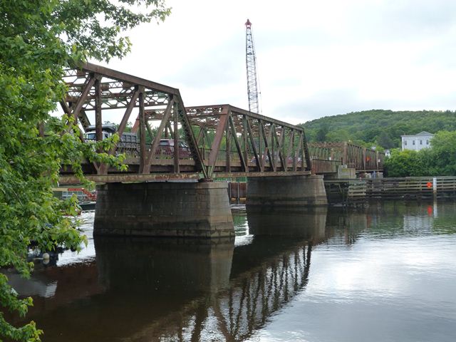
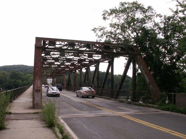
The Groveland Bridge has an interesting history. An 1882 swing bridge at the location lost three of its southeastern spans to a fire. As such, three new through truss spans were built in 1913-1914 as replacements. Later, the swing span, and the remaining two fixed spans at the northwestern end of the bridge were replaced in 1951. Boston Bridge Works was responsible for building the three 1913 spans. T. Stuart and Sons Company was the contractor for the 1950 spans, with the steel fabricator being the American Bridge Company of New York, New York.
The bridge is officially named after Congressman William H. Bates.
|
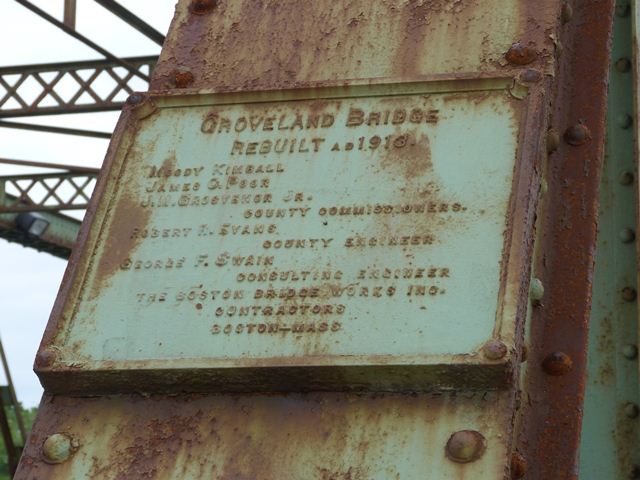
Main Plaque GROVELAND BRIDGEREBUILT AD 1913. MOODY KIMBALL JAMES C. POOR J. M. GROSVENOR JR. COUNTY COMMISSIONERS. ROBERT EVANS COUNTY ENGINEER GEORGE F. SWAIN CONSULTING ENGINEER THE BOSTON BRIDGE WORKS INC. CONTRACTORS BOSTON -MASS |
Information and Findings From The Massachusetts Historic Bridge InventoryDescription Describe: Banks of Merrimack are heavily wooded, screening the mostly residential neighborhoods behind. Groveland's center village, a 19th-century rural trading center with some 20th-century commercial intrusions, is situated at the southerly end of the bridge. History of bridge and site: A chain ferry on this site at least as early as 1827 was replaced in 1870 by an iron bowstring truss drawbridge which collapsed within 10 years. It was replaced in 1882 by a 6-span iron truss bridge (one span a rim-bearing swing) designed and built by the Boston Bridge Works. The 3 southerly spans of the 1882 bridge burned in 1913 and were replaced by the present 3 southerly spans. The remaining (northerly) spans of the 1882 bridge were replaced by the present northerly through trusses and bascule span in 1950. Statement of Significance The 1950 bascule span is the 11th-oldest of 20 trunnion-type bascule spans identified in the MDPW statewide computer print-out. It is one of 29 bascule spans of all types identified in the MDPW print-out, and one of 14 single-leaf bascule spans included among the 29. (These totals do not include an unknown number of railroad bascules which are not covered in the MDPW listing) . The 5 through truss spans, 2 dating from 1950 and 3 from 1913, are all of the standard Pratt configuration (Pratts being one of the two most common types among surviving truss bridges) and both sets of truss spans utilize the more modern riveted connections rather than the earlier pinned construction. Alterations Present sidewalk probably dates to 1950 as it looks original on 3 northern spans but is clearly added to 3 southern ones. Latticed railing on westerly side 3 southern spans (1913) quite possibly original. Bridge Considered Historic By Survey: Yes |
![]()
![]()
![]()
![]()
![]()
![]()
![]()
This historic bridge has been demolished. This map is shown for reference purposes only.
Coordinates (Latitude, Longitude):
Search For Additional Bridge Listings:
Bridgehunter.com: View listed bridges within 0.5 miles (0.8 kilometers) of this bridge.
Bridgehunter.com: View listed bridges within 10 miles (16 kilometers) of this bridge.
Additional Maps:
Google Streetview (If Available)
GeoHack (Additional Links and Coordinates)
Apple Maps (Via DuckDuckGo Search)
Apple Maps (Apple devices only)
Android: Open Location In Your Map or GPS App
Flickr Gallery (Find Nearby Photos)
Wikimedia Commons (Find Nearby Photos)
Directions Via Sygic For Android
Directions Via Sygic For iOS and Android Dolphin Browser
USGS National Map (United States Only)
Historical USGS Topo Maps (United States Only)
Historic Aerials (United States Only)
CalTopo Maps (United States Only)

© Copyright 2003-2024, HistoricBridges.org. All Rights Reserved. Disclaimer: HistoricBridges.org is a volunteer group of private citizens. HistoricBridges.org is NOT a government agency, does not represent or work with any governmental agencies, nor is it in any way associated with any government agency or any non-profit organization. While we strive for accuracy in our factual content, HistoricBridges.org offers no guarantee of accuracy. Information is provided "as is" without warranty of any kind, either expressed or implied. Information could include technical inaccuracies or errors of omission. Opinions and commentary are the opinions of the respective HistoricBridges.org member who made them and do not necessarily represent the views of anyone else, including any outside photographers whose images may appear on the page in which the commentary appears. HistoricBridges.org does not bear any responsibility for any consequences resulting from the use of this or any other HistoricBridges.org information. Owners and users of bridges have the responsibility of correctly following all applicable laws, rules, and regulations, regardless of any HistoricBridges.org information.
![]()