

View Information About HSR Ratings
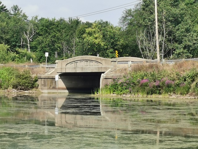
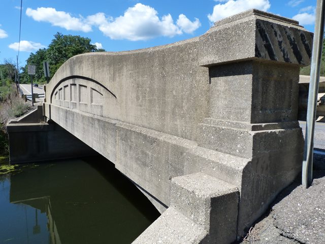
This bridge is the oldest of three curved chord through girders in Allegan County. All three are 50 foot examples. All three bridges should be considered historically significant, and all three carry a moderate volume of traffic and have a structural condition that makes preservation feasible, and as such these bridges deserve nothing less. With concrete bridges, it is better to schedule rehabilitations before deterioration becomes advanced, so the time to plan for a rehabilitation of this bridge should be now. This bridge crosses the creek where a small dam is also located. The bridge is located in a State Game area, and there is a boat launch and picnic area to the south of the bridge. Beautiful views of the bridge can be had south of the bridge from this area. As such, the bridge is a contributing asset to this public hunting and park-like area.
Michigan's Concrete Camelback Bridges
All of Michigan's surviving curved chord through girders should be considered historically and technologically significant. The bridges are historically significant because they represent a unique and innovative design developed by the Michigan State Highway Department in its earlier years of bridge construction.
The bridges should be considered technologically significant as well. By incorporating a curve into the design, Michigan State Highway Department not only increased the efficiency of the design, they also greatly increased the aesthetic value of the bridges. The graceful curves of this bridge type, complemented by architectural details such as inset rectangles make them among the most aesthetically pleasing of bridge types ever encountered. Straight chord through girder bridges are generally considered among the more plain and less visually appealing types of historic bridges. The aesthetic qualities of the curved girder bridge, those qualities being an integral and functional part of the bridge and not a decorative facade, should be considered to be a technologically significant feat: an extremely effective union of function and form.
Statewide, very few examples of this bridge type have been preserved or have evidence of a preservation commitment. Further, the number of examples of this bridge type have been dropping rapidly over the years. Considering that in recent years, Michigan has begun to emerge as a leader in truss bridge preservation, it is reasonable to consider concrete camelback bridges to be the most threatened type of historic bridge in Michigan.
The bridge type has become rare through attrition in Michigan, and the rarity of the bridges today only adds to the significance of those remaining examples.
This bridge is tagged with the following special condition(s): Unorganized Photos
![]()
![]()
![]()
![]()
![]()
Coordinates (Latitude, Longitude):
Search For Additional Bridge Listings:
Bridgehunter.com: View listed bridges within 0.5 miles (0.8 kilometers) of this bridge.
Bridgehunter.com: View listed bridges within 10 miles (16 kilometers) of this bridge.
Additional Maps:
Google Streetview (If Available)
GeoHack (Additional Links and Coordinates)
Apple Maps (Via DuckDuckGo Search)
Apple Maps (Apple devices only)
Android: Open Location In Your Map or GPS App
Flickr Gallery (Find Nearby Photos)
Wikimedia Commons (Find Nearby Photos)
Directions Via Sygic For Android
Directions Via Sygic For iOS and Android Dolphin Browser
USGS National Map (United States Only)
Historical USGS Topo Maps (United States Only)
Historic Aerials (United States Only)
CalTopo Maps (United States Only)

© Copyright 2003-2024, HistoricBridges.org. All Rights Reserved. Disclaimer: HistoricBridges.org is a volunteer group of private citizens. HistoricBridges.org is NOT a government agency, does not represent or work with any governmental agencies, nor is it in any way associated with any government agency or any non-profit organization. While we strive for accuracy in our factual content, HistoricBridges.org offers no guarantee of accuracy. Information is provided "as is" without warranty of any kind, either expressed or implied. Information could include technical inaccuracies or errors of omission. Opinions and commentary are the opinions of the respective HistoricBridges.org member who made them and do not necessarily represent the views of anyone else, including any outside photographers whose images may appear on the page in which the commentary appears. HistoricBridges.org does not bear any responsibility for any consequences resulting from the use of this or any other HistoricBridges.org information. Owners and users of bridges have the responsibility of correctly following all applicable laws, rules, and regulations, regardless of any HistoricBridges.org information.
![]()